Monroe Township, Clark County, Indiana

Last updated

Monroe Township
Map highlighting Monroe Township, Clark County, Indiana.svg
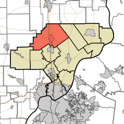
Location of Monroe Township in Clark County
Coordinates: 38°32′41″N85°46′25″W / 38.54472°N 85.77361°W / 38.54472; -85.77361
Country United States
State Indiana
County Clark
Government
  Type Indiana township
Area
  Total
56.06 sq mi (145.2 km2)
  Land55.78 sq mi (144.5 km2)
  Water0.28 sq mi (0.73 km2)
Elevation
[1]
520 ft (160 m)
Population
 (2020) [2]
  Total
5,610
  Density96.9/sq mi (37.4/km2)
FIPS code 18-50274 [3]
GNIS feature ID 453636

Monroe Township is one of twelve townships in Clark County, Indiana. As of the 2010 census, its population was 5,402 and it contained 2,125 housing units. [4]

Contents

History

Monroe Township was organized prior to 1827 but the exact date is unclear because records have been lost. It was likely named for President James Monroe. [5]

Geography

According to the 2010 census, the township has a total area of 56.06 square miles (145.2 km2), of which 55.78 square miles (144.5 km2) (or 99.50%) is land and 0.28 square miles (0.73 km2) (or 0.50%) is water. [4]

Unincorporated towns

Adjacent townships

Major highways

Cemeteries

The township contains several cemeteries: Blue Lick Cemetery (a.k.a. Mountain Grove), Bowerman Cemetery, Cass, Clegg (a.k.a. Mt. Moriah), Collings, Dieterlen Grave, Dietz, Forest Grove (a.k.a. Willey's Chapel), Guernsey, Henryville, Hylton-Condrey, Hosea Family, Kaylor-Wilcox, Little Union (a.k.a. Gross), McBride-Allen-Biggs (a.k.a. Allen), Mt. Lebanon, Mt. Moriah, Mt. Zion, Otisco II, St. Clair, St. Francis Catholic (a.k.a. Henryville Catholic), Tuttle, and Wootan. [6]

References

  1. "US Board on Geographic Names". United States Geological Survey. October 25, 2007. Retrieved January 31, 2008.
  2. "Census Bureau profile: Monroe Township, Clark County, Indiana". United States Census Bureau. May 2023. Retrieved March 21, 2024.
  3. "U.S. Census website". United States Census Bureau . Retrieved January 31, 2008.
  4. 1 2 "Population, Housing Units, Area, and Density: 2010 - County -- County Subdivision and Place -- 2010 Census Summary File 1". United States Census. Archived from the original on February 12, 2020. Retrieved May 10, 2013.
  5. History of the Ohio Falls Cities and Their Counties: Precincts of Jefferson County, Ky. General histories of Clark and Floyd counties, Ind. New Albany and Floyd County. Clark County and Jeffersonville. L. A. Williams & Company. 1882. p.  357.
  6. Mauk, Lois. "Clark County, Indiana Cemeteries". usgennet.org. USGenNet. Retrieved September 7, 2014.