Henryville, Indiana | |
|---|---|
 Location of Henryville in Clark County, Indiana. | |
| Coordinates: 38°32′18″N85°45′20″W / 38.53833°N 85.75556°W | |
| Country | United States |
| State | Indiana |
| County | Clark |
| Township | Monroe |
| Area | |
• Total | 2.83 sq mi (7.33 km2) |
| • Land | 2.83 sq mi (7.32 km2) |
| • Water | 0.00 sq mi (0.01 km2) |
| Elevation | 495 ft (151 m) |
| Population (2020) | |
• Total | 1,878 |
| • Density | 664.78/sq mi (256.64/km2) |
| Time zone | UTC-5 (EST) |
| • Summer (DST) | UTC-4 (EDT) |
| ZIP code | 47126 |
| Area code | 812 |
| FIPS code | 18-33142 [3] |
| GNIS feature ID | 2393047 [2] |

Henryville is a census-designated place (CDP) in Monroe Township, Clark County, in the U.S. state of Indiana. [4] The population was 1,905 at the 2010 census.
Contents
- History
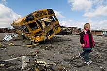
- 2012 tornado
- Geography
- Climate
- Demographics
- Education
- Infrastructure
- Highway
- Rail
- References
- External links
Henryville is home to Indiana's oldest state forest, Clark State Forest, and birthplace of entrepreneur Colonel Harland Sanders, whose iconic image appears in the Kentucky Fried Chicken logo [5] and Grammy award-winning bluegrass fiddle player Michael Cleveland. [6]
