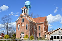
, Indiana | |
---|---|
Coordinates: 38°33′56″N85°32′46″W / 38.56556°N 85.54611°W | |
Country | United States |
State | Indiana |
County | Clark |
Township | Washington |
Area | |
• Total | 5.22 sq mi (13.52 km2) |
• Land | 5.21 sq mi (13.49 km2) |
• Water | 0.01 sq mi (0.04 km2) |
Elevation | 715 ft (218 m) |
Population (2020) | |
• Total | 595 |
• Density | 114.25/sq mi (44.11/km2) |
Time zone | UTC-5 (Eastern (EST)) |
• Summer (DST) | UTC-4 (EDT) |
ZIP code | 47162 |
Area code | 812 |
FIPS code | 18-53820 [3] |
GNIS feature ID | 2393150 [2] |
New Washington is a census-designated place (CDP) in Clark County, Indiana, United States. As of the 2010 census, the population was 566. [4]
New Washington was established in 1815. [5] A post office was established at New Washington in 1819. [6]
New Washington was the closest community to the now-defunct Marble Hill Nuclear Power Plant. [7]
New Washington is located in northeastern Clark County. Indiana State Road 62 runs through the center of the community, leading north then east 19 miles (31 km) to Madison and southwest 24 miles (39 km) to Jeffersonville across the Ohio River from Louisville, Kentucky.
According to the United States Census Bureau, the CDP has a total area of 5.2 square miles (13.5 km2), of which 0.02 square miles (0.04 km2), or 0.29%, is water. [4]
Census | Pop. | Note | %± |
---|---|---|---|
2020 | 595 | — | |
U.S. Decennial Census [8] |
As of the census [3] of 2000, there were 547 people, 228 households, and 163 families residing in the CDP. The population density was 104.8 inhabitants per square mile (40.5/km2). There were 253 housing units at an average density of 48.5 per square mile (18.7/km2). The racial makeup of the CDP was 99.63% White and 0.37% African American.
There were 229 households, out of which 27.6% had children under the age of 18 living with them, 58.8% were married couples living together, 10.5% had a female householder with no husband present, and 28.5% were non-families. 25.0% of all households were made up of individuals, and 12.7% had someone living alone who was 65 years of age or older. The average household size was 2.38 and the average family size was 2.85.
In the CDP the population was spread out, with 20.7% under the age of 18, 10.1% from 18 to 24, 26.7% from 25 to 44, 26.7% from 45 to 64, and 15.9% who were 65 years of age or older. The median age was 40 years. For every 100 females, there were 85.4 males. For every 100 females age 18 and over, there were 79.3 males.
The median income for a household in the CDP was $37,368, and the median income for a family was $42,292. Males had a median income of $31,359 versus $14,750 for females. The per capita income for the CDP was $19,343. About 2.3% of families and 8.2% of the population were below the poverty line, including 18.3% of those under age 18 and 16.9% of those age 65 or over.
New Washington has a public library, elementary school, [9] middle/high school, [10] and a branch of the Charlestown-Clark County Public Library. [11]
Charlestown is a city located within Charlestown Township, in Clark County, Indiana, United States. The population was 7,775 at the 2020 census.
Henryville is a census-designated place (CDP) in Monroe Township, Clark County, in the U.S. state of Indiana. The population was 1,905 at the 2010 census.
Memphis is a census-designated place (CDP) in Clark County, Indiana, United States. The population was 695 at the 2010 census.
Oak Park is a census-designated place (CDP) in Clark County, Indiana, United States. The population was 5,379 at the 2000 census.
Sellersburg is a town located within Silver Creek Township, Clark County, Indiana, United States. It had a population of 9,310 at the time of the 2020 census. Sellersburg is located along Interstate 65, about 15 minutes north of Louisville.
Dunlap is a census-designated place (CDP) in Elkhart County, Indiana, United States. The population was 6,235 at the 2010 census. Once a small farming community, by the 1980s it had become a suburb of Elkhart and Goshen, Indiana. Most of the town was destroyed by two violent F4 tornadoes during the Palm Sunday Tornado Outbreak on April 11, 1965.
New Paris is a census-designated place (CDP) in Elkhart County, Indiana, United States. The population was 1,494 at the 2010 census.
Simonton Lake is a census-designated place (CDP) in Elkhart County, Indiana, United States. The population was 4,678 at the 2010 census.
Galena is a census-designated place (CDP) in Floyd County, Indiana, United States. The population was 1,818 at the 2010 census. The CDP includes the town of Galena as well as the nearby town of Floyds Knobs and their immediate surroundings.
Collegeville is a census-designated place (CDP) in Jasper County, Indiana, United States. The population was 330 at the 2010 census. Collegeville is home to the now-unaccredited Saint Joseph's College, the source of the town's name.
Clinton is an unincorporated community and census-designated place (CDP) in Missoula County, Montana, United States. It is part of the Missoula metropolitan area. The population was 1,018 at the 2020 census.
Zia Pueblo is a census-designated place (CDP) in Sandoval County, New Mexico, United States. The population was 646 at the 2000 census, with 310 males and 336 females. The pueblo after which the CDP is named is included within the CDP; it is listed on the National Register of Historic Places.
Ross is a census-designated place (CDP) in Ross Township, Butler County, Ohio, United States. The population was 3,478 at the 2020 census. Ross sits along U.S. Route 27 between Cincinnati, Ohio and Oxford, Ohio. Ross is part of the Cincinnati metropolitan area.
Holiday Valley is a census-designated place (CDP) in Mad River Township, Clark County, Ohio, United States. The population was 1,480 at the 2020 census. It is part of the Springfield, Ohio Metropolitan Statistical Area. Holiday Valley became a CDP in the 1990 United States Census.
Barberton is a census-designated place (CDP) in Clark County, Washington, United States. The population was 8,567 at the 2020 census.
Cherry Grove is a census-designated place (CDP) in Clark County, Washington, United States. The population was 588 at the 2020 census.
Lewisville is a census-designated place (CDP) in Clark County, Washington, United States. The population was 1,860 at the 2020 census.
Mount Vista is a census-designated place (CDP) in Clark County, Washington, United States. It includes the Vancouver campus of Washington State University. The population of Mount Vista was 10,051 at the 2020 census.
Salmon Creek is a census-designated place (CDP) in Clark County, Washington, United States. The population was 21,293 at the 2020 census.
Charlestown is a census-designated place (CDP) and the main village in the town of Charlestown, Sullivan County, New Hampshire, United States. The population of the CDP was 1,078 at the 2020 census, out of 4,806 in the entire town.
This village was laid out in 1815...