Montauk | |
|---|---|
 Old Mill at Montauk State Park | |
 Montauk | |
| Coordinates: 37°26′52″N91°41′45″W / 37.44778°N 91.69583°W | |
| Country | United States |
| State | Missouri |
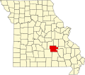
| County | Dent County |
| Time zone | UTC-6 (Central (CST)) |
| • Summer (DST) | UTC-5 (CDT) |
Montauk is an unincorporated community in southwestern Dent County, Missouri, United States. [1] It is located on Route 119, on the Current River and is in the Ozark National Scenic Riverways. Montauk State Park, famed for its rainbow and brown trout, is here.
A post office called Montauk was in operation from 1851 to 1974. [2] The community was named after the Montaukett Indians. [3]