Lenox | |
|---|---|
 Lenox | |
| Coordinates: 37°39′11″N91°45′41″W / 37.65306°N 91.76139°W | |
| Country | United States |
| State | Missouri |
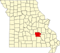
| County | Dent County |
| Time zone | UTC-6 (Central (CST)) |
| • Summer (DST) | UTC-5 (CDT) |
Lenox is an unincorporated community in western Dent County, Missouri, United States. [1] The community is located approximately twelve miles west of Salem at the intersection of routes H and C. Edgar Springs is approximately four miles to the northwest in adjacent Phelps County and the community of Maples is 4.5 miles to the south in Texas County. [2]
A post office called Lenox was established in 1884, and remained in operation until 1998. [3] The community has the name of the local Lenox family, pioneer citizens. [4]