Coulstone | |
|---|---|
 Coulstone | |
| Coordinates: 37°31′22″N91°45′05″W / 37.52278°N 91.75139°W | |
| Country | United States |
| State | Missouri |
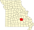
| County | Dent County |
| Elevation | 1,112 ft (339 m) |
| Time zone | UTC-6 (Central (CST)) |
| • Summer (DST) | UTC-5 (CDT) |
| GNIS feature ID | 740770 [1] |
Coulstone is an unincorporated community in western Dent County, in the U.S. state of Missouri.
The community is on Missouri Route 32 adjacent to the Dent-Texas county line. Licking is 5.5 miles (8.9 km) to the west and Salem is approximately 14 miles (23 km) to the northeast along Route 32. Pigeon Creek flows past the community. [2]