Anutt | |
|---|---|
 Anutt | |
| Coordinates: 37°42′57″N91°43′12″W / 37.71583°N 91.72000°W | |
| Country | United States |
| State | Missouri |
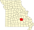
| County | Dent County |
| Elevation | 1,207 ft (368 m) |
| Time zone | UTC-6 (Central (CST)) |
| • Summer (DST) | UTC-5 (CDT) |
| GNIS feature ID | 713351 [1] |
Anutt is an unincorporated community in western Dent County, in the U.S. state of Missouri. [1]
The community is located along a ridge at the intersection of routes O and C approximately 15 miles (24 km) south of Rolla. The community of Lenox is 4.5 miles (7.2 km) to the south along Route C. Edgar Springs is seven miles (11 km) to the west in Phelps County and Salem is 12 miles (19 km) to the east. [2] [3]