Howes Mill | |
|---|---|
 Howes Mill | |
| Coordinates: 37°37′04″N91°17′30″W / 37.61778°N 91.29167°W | |
| Country | United States |
| State | Missouri |
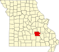
| County | Dent County |
| Elevation | 1,378 ft (420 m) |
| Time zone | UTC-6 (Central (CST)) |
| • Summer (DST) | UTC-5 (CDT) |
| GNIS feature ID | 758436 [1] |
Howes Mill is an unincorporated community in eastern Dent County, in the U.S. state of Missouri. [1]
Contents
The community is approximately 12.5 miles east of Salem on Missouri Route 32. The Howes Mill spring is two miles to the northeast on the West Fork of Huzzah Creek. [2] [3]