Joy | |
|---|---|
 Joy road marker in 2003. The sign was not present in 2017. | |
 Joy | |
| Coordinates: 37°30′52″N91°40′28″W / 37.51444°N 91.67444°W | |
| Country | United States |
| State | Missouri |
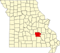
| County | Dent County |
| Elevation | 1,299 ft (396 m) |
| Time zone | UTC-6 (Central (CST)) |
| • Summer (DST) | UTC-5 (CDT) |
| GNIS feature ID | 740975 [1] |
Joy is an unincorporated community in southwest Dent County, in the U.S. state of Missouri. [1]
The community is located on Missouri Route E just east of Missouri Route 119. Salem is approximately eleven miles (18 km) to the northeast and Montauk State Park is about four miles (6.4 km) to the south. Licking in adjacent Texas County is about nine miles (14 km) to the southwest. [2]