São Nicolau is one of the Barlavento (Windward) islands of Cape Verde. It is located between the islands of Santa Luzia and Sal. Its population is 12,424 (2015), with an area of 343 km². The main towns are Ribeira Brava and Tarrafal de São Nicolau.

Boa Vista, also written as Boavista, is a desert-like island that belongs to the Cape Verde Islands. At 631.1 km2 (243.7 sq mi), it is the third largest island of the Cape Verde archipelago.

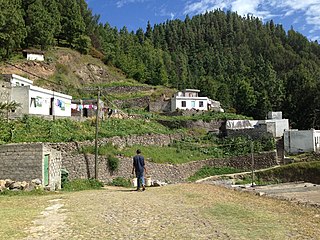
São Lourenço dos Órgãos is a concelho (municipality) of Cape Verde. It is situated in the mountainous central part of the island of Santiago. Its seat is the city João Teves. Its population was 7,388 at the 2010 census, and its area is 36.9 km2. The municipality is bordered by Santa Cruz to the northeast, São Domingos to the south, Ribeira Grande de Santiago to the southwest and São Salvador do Mundo to the northwest. Pico de Antónia, the island's highest mountain, straddles the borders of São Lourenço dos Órgãos, São Salvador do Mundo and Ribeira Grande de Santiago.
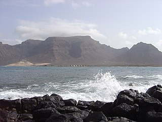
Monte Verde is a mountain in the eastern part of the island of São Vicente, Cape Verde. At 744 m elevation, it is the island's highest point. The mountain is located 6 km (4 mi) east of the city centre of Mindelo.
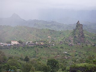
Picos, also known as Achada Igreja, is a city in the central part of the island of Santiago, Cape Verde. It is the seat of São Salvador do Mundo municipality. Picos is located 4 km southeast of Assomada and 23 km northwest of the capital city of Praia, near the national road from Praia to Tarrafal via Assomada (EN1-ST01).

Tope de Coroa is a mountain on the island of Santo Antão's, Cape Verde. At 1,979 m elevation, it is the highest point of the island. It is in the western part of the island, 25 km west of the island capital Porto Novo. The mountain is entirely of volcanic origin. The area is the source of several streams including Ribeira de Monte Trigo which flows westward to Monte Trigo.
Monte Gordo is a mountain on the island of São Nicolau, Cape Verde. At 1,312 m elevation, it is the island's highest point. It is situated in the western part of the island, 6 km west of the island capital Ribeira Brava. The mountain is of volcanic origin, less than 1 million years old. The boundary of the municipalities Tarrafal de São Nicolau and Ribeira Brava runs over the mountain. It is part of the Monte Gordo Natural Park.

Monte Penoso is a mountain on the island of Maio, Cape Verde. At 436 m elevation, it is the island highest point. It is situated in the eastern part of the island, 3 km southwest of Pedro Vaz and 13 km northeast of the island capital Porto Inglês. The mountain is of volcanic origin. It is part of the protected landscape Monte Penoso and Monte Branco, which covers 11.17 km2 (4.31 sq mi).

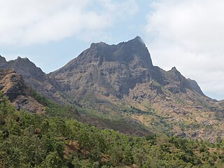
Pico de Antónia is a mountain located in the central part of the island of Santiago in Cape Verde. At 1,392 m (4,567 ft), it is the highest point of the island. The mountain is part of the protected area Parque Natural da Serra do Pico de Antónia. The towns Picos and Assomada lie close to the mountain. The Serra do Pico da Antónia has been identified by BirdLife International as an Important Bird Area.

Ribeira de Calhau is a settlement in the eastern part of the island of Sao Vicente, Cape Verde. It takes its name from the river Ribeira do Calhau, and comprises the villages of Madeiral, Ribeira de Calhau and Calhau. Madeiral and Ribeira de Calhau are located in the river valley, Calhau is on the east coast. In 2010 its population was 1,177. The valley is surrounded by the mountains Viana, Madeiral, Pico do Vento and Monte Verde.

Monte Graciosa is a mountain in the northern part of the island of Santiago in Cape Verde. It lies 2.5 km north of the town of Tarrafal, overlooking the Baía de Tarrafal. Its elevation is 643 m. Towards the west it ends in the headland of Ponta Preta. It is part of a larger proposed natural park. The mountain is of volcanic origin, composed of phonolite and rich in feldspar and olivine.
Monte Caçador and Pico Forcado Protected Countryside is a protected area covering 3,357 hectares (12.96 sq mi) of land in the eastern part of the island of Boa Vista in Cape Verde. It is the most important mountain formation on the island, but not the highest.
Monte Velha is a peak in the northeastern part of the island of Fogo in Cape Verde. Its elevation is 1,482 m. It is a subpeak of the Pico do Fogo volcano, located at the northeastern end of the crater rim. It lies within the municipality of Mosteiros, 4 km southwest of the city centre. Its forest is a protected area, part of the larger Fogo Natural Park.
Pico da Cruz is a settlement in the northeastern part of the island of Santo Antão, Cape Verde. In 2010 its population was 138. It is situated 6 km southwest of Pombas and 10 km northeast of the island capital Porto Novo. Its elevation is about 1,400 meters. The village is named after the nearby mountain Pico da Cruz. It lies in the Cova-Paul-Ribeira da Torre Natural Park.

Ribeira Seca is the largest stream of the island of Santiago in Cape Verde. It is 18 km (11 mi) long and its basin area is 71.5 km2 (27.6 sq mi). Located in the eastern part of the island, it flows through the municipalities of São Lourenço dos Órgãos and Santa Cruz. Its source is near the highest point of the island, Pico de Antónia, from where it flows to the east to João Teves. It turns to the northeast and flows into the Atlantic Ocean at Achada Fazenda, 2 km southeast of Pedra Badejo. It is called Ribeira de Pico da Antónia in its uppermost part, and Ribeira de Lage near João Teves.

Longueira is a village in the southcentral part of the island of Santiago, Cape Verde. In 2010 its population was 326. Longueira is located 4 km southwest of João Teves and 1.5 km west of São Jorge. Monte Tchota, the highest point of the mountains of Rui Vaz, lies to the south.

Bordeira is a semicircular mountain in the middle of the island Fogo. It is a crater rim, up to 1 km high, formed by a prehistoric collapse of the volcano Pico do Fogo. At a maximum elevation of 2,692 metres (8,832 ft), it is the second highest point in the nation behind Pico do Fogo. The name literally means the "border". It forms part of Fogo Natural Park. Opening to the east, it effectively protects the northern, western and southern part of the island against lava flows from the volcano. The settlement Chã das Caldeiras lies at the foot of Bordeira, in the caldera. The east side of the Bordeira cliff is much steeper than the west side.