Santiago is the largest island of Cape Verde, its most important agricultural centre and home to half the nation’s population. Part of the Sotavento Islands, it lies between the islands of Maio and Fogo. It was the first of the islands to be settled: the town of Ribeira Grande was founded in 1462. Santiago is home to the nation's capital city of Praia.
Cape Verde or Cabo Verde, officially the Republic of Cabo Verde, is an island country spanning an archipelago of 10 volcanic islands in the central Atlantic Ocean. It forms part of the Macaronesia ecoregion, along with the Azores, Canary Islands, Madeira, and the Savage Isles. In ancient times these islands were referred to as "the Islands of the Blessed" or the "Fortunate Isles". Located 570 kilometres (350 mi) west of the Cape Verde Peninsula off the coast of Northwest Africa, the islands cover a combined area of slightly over 4,000 square kilometres (1,500 sq mi).
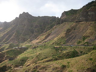
During the Prehistoric era, around 22 to 21 million years ago, the seamount was formed, 4 to 3 million years ago, the island with its crater now known as Pico da Antónia was formed, its length was about 15km, about 2 to 3 million years ago, another island with its crater at present day Serra da Malagueta was formed, its seamount was formed around 20 to 19 million years ago, its length was about 10km, about 2 to 1 million years ago, the two islands merged into a larger island. Around 1 million years ago, its reptiles and insects came to the island along with its flora as likely a couple of trees from its collapsed banks of the rivers of the African mainland, mostly the Senegal River were rafted onto the island when the salinity of the ocean was lower. In about 73,000 BC, the eastern portion of the island of Fogo collapsed into the ocean and brought a 170 meter high megatsunami that flooded the western part of the island.[1] During the Ice Age, the island was larger than 1,050km² and approximately 80km wide.
Colonial and provincial Santiago Island
The pillory in Cidade Velha.Drake at Santiago, Cape Verde, 1589 hand-colored engraving, by Baptista Boazio, 1589Santiago Island, a 1647 painting by Caspar Schmalkalden
The island was discovered by the explorer António da Noli in around 1460 who built a garrison in Cidade Velha which was then known as Ribeira Grande, it was the first settlement in Cape Verde and was a Portuguese colony until 1975. Its first settlers came from Madeira. It became the colonial of a captaincy that was broken into two on 19 September 1462, the other one was later centered in the north of the island around the end of the 15th century and that captaincy dissolved in 1505. Its first slaves arrived in 1466 and was the first island that started slavery, slavery spread to other parts of the island and continued for over three centuries. The first colonial church, Nossa Senhora do Rosário (Our Lady of Rosary) started to be built in 1493 and was finished in 1495. Rua Banana was constructed and was the first made main urban street in the tropics in the Portuguese Empire. Slavery was at its fullest around the start of the 16th century and brought Africans from mainly the Balanta, Papel, Bijagó (rarely Bissagos, or Bidyogo) and the Mendé peoples. They were divided into three groups, the "boços" ("stupid", slaves who spoke African languages), the "ladinos" ("Latins", as in "Latinized", slaves who spoke Portuguese creole) and the "nativos" ("natives", slaves born in the archipelago). The island's population reached 13,000 in 1513, of whom 167 were not slaves. Later, transcontinental slavery made Cidade Velha the second richest city in the Portuguese realm. The city was also an exporter of sugar and cloth. Portugal later faced competition by the English, Dutch, French and Spanish who gradually took over the slave trade The main part of the south of the island was forested, they were cleared for farming and some of them became groves. In the 15th century, several animals were brought mostly from the Old World mainland by boat, they brought farm animals including cattle, a few monkeys as the island being the only place that are found today in Cape Verde, cats and dogs, rodents and later frogs, also later a couple of flora came on boat from the Old World mainland and the New World. Cape Verde's first pillory was constructed in 1520[clarification needed]. Villages were founded in the middle of the island around the mid-16th century. Decades later in the north São Domingos was established and later Assomada and Pedra Badejo, by the 17th century, settlement appeared in many areas across the island. Construction of the Sé Cathedral started in 1555, was completely stopped for over a century, and completed in 1699. Ribeira Grande became Cape Verde's first city. The Philippine Dynasty came to power in 1585 which would last into 1645 and not until the 1650s when an independent Portuguese administration was restored. The island was captured by Francis Drake,[2] as a result, Fort Real de São Filipe, Cape Verde's first fortress was built on November 17, 1585 and was finished in 1590, São Domingos was also looted.[3][4] and on November 28 Porto Praya (now Praia) razed, only the town hospital was spared, the fleet left after November, this was part of the Anglo-Spanish War (1585). In 1587, Ribeira Grande became the unified colonial capital of Cape Verde. A hand-colored engraving on the raid on Ribeira Grande (common name was Cape Verde City or Cidade de Cabo Verde, now Cidade Velha) by Giovanni Battista Boazio was the first engraving about Cape Verde or any of its islands.
Cidade Velha is a city in the southern part of the island of Santiago, Cape Verde. Founded in 1462, it is the oldest settlement in Cape Verde and its former capital. Once called Ribeira Grande, its name was changed to Cidade Velha in the late 18th century. It is the seat of the Ribeira Grande de Santiago municipality.
Cape Verde was a colony of the Portuguese Empire from the initial settlement of the Cape Verde Islands in 1462 until the independence of Cape Verde in 1975.
The Balanta are an ethnic group found in Guinea-Bissau, Senegal and The Gambia. They are the largest ethnic group of Guinea-Bissau, representing more than one-quarter of the population. Despite their numbers, they have remained outside the colonial and postcolonial state because of their social organisation. The Balanta can be divided into four subgroups, three of which are Balanta Kentohe, Balanta Ganja and Balanta Brassa, the largest of which are the Balanta Brassa.
In 1615 (some sources stated 1612), in the area of the southeasternmost part of the island, Praia de Santa Maria appeared on the previous settlement on the plateau (founded around the early 16th century); decades later, it became known as Porto Praya and Porto Praia, and is now known as Praia. Praia had its own captaincy which existed from 1526 to around 1580. Later, Praia was initially used as a clandestine harbor (in order to avoid customs fees at the then capital Ribeira Grande. Elisabeth van der Woude of Nieuw Niedorp described in her diary on her way to Dutch Guyana (now Surinam) visited the island in 1677 where her father had to be buried illegally because he was a Reformed Protestant, not a Catholic.[5] On May 5, 1712, the French corsairs commanded by Jacques Cassard with his 12 ships landed on Praia Harbor in the south of the island, later Cidade Velha and its fort were attacked and destroyed by his forces in the Cassard expedition in 1712, the corsairs occupied a good part of the island, the bishop Francisco Santo Agostinho retired into the interior, where he reorganized his forces for the defence, leadership and resistance for a counterattack. The corsairs took the bells from the cathedral, its relics and the wooded furniture. Things that were not taken were burned down including the rich library of the bishop, damages totalled 3 million French livres.[6] From the attack, Cidade Velha ceased to be the capital, which was moved to the Praia plateau. Praia was not officially the capital until 1770. Jan Frans Michel from Mechelen in the Austrian Netherlands (now Belgium) was put ashore on the island at Praia on November 15, 1752 on a second voyage to China under the Prussian Asiatic Company, there he described that the port's soil is sandy while the soil in the remainder of the island were shallow and sludgy.[7]
Praia, is the capital and largest city of Cape Verde, an island nation in the Atlantic Ocean west of Senegal. It lies on the southern coast of Santiago island in the Sotavento Islands group. It is the island's ferry port and is home to one of the nation's four international airports. The city centre is known as Plateau due to its location on a small plateau.
Elisabeth van der Woude was a Dutch traveller and author.
Jacques Cassard was a French naval officer and privateer.
Map of Santiago Island in 1772A depiction of Praia during the Battle of Porto Praya
Though Portugal was neutral throughout the Anglo-French War and American Revolutionary War), the Battle of Porto Praya between Great Britain and France, won by France, took place off modern day Praia at Praia Harbor on April 16, 1780. Cotton was first grown on the island of Santiago in around 1794, it was made by the colonial governor José da Silva Maldonado de Eça.[8]
The American Revolutionary War, also known as the American War of Independence, was a war between Great Britain and its Thirteen Colonies which declared independence as the United States of America.
The Battle of Porto Praya was a naval battle that took place during the American Revolutionary War on 16 April 1781 between a British squadron under Commodore George Johnstone and a French squadron under the Bailli de Suffren.
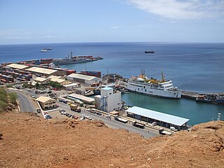
Praia Harbor is the port of the city of Praia in the southern part of the island of Santiago, Cape Verde. It is situated in a natural bay of the Atlantic Ocean. Since the latest modernization in 2014, it has 2 long quays, 3 shorter quays, a quay for fishing boats with fish processing installations, 2 container parks, 2 roll-on/roll-off ramps and a passenger terminal. The total length of the quays is 863 m, and the maximum depth is 13.5 m. The port of Praia played an important role in the colonization of Africa and South America by the Portuguese. With 817,845 metric tonnes of cargo and 85,518 passengers handled (2017), it is the second busiest port of Cape Verde, after Porto Grande (Mindelo).
A rebellion led by Manuel António Martins, who later became governor, took place in Praia. António Pusich was overthrown in favour of João da Mata Chapuzet. Under the next governor the colonial capital underwent a large modernization; one of the new buildings was Quartel Jaime Mota,[9] started on May 8, 1822 and finished in 1826. The island and Porto Praya were visited by scientist and naturalist Charles Darwin on HMS Beagle;[10] he later visited Ilhéu de Santa Maria[11] before he headed to the islands off the northeast coast of Brazil, there Darwin discovered a sparrow species that would later be called the Iago sparrow (Passer iagoensis). A plan to move the colonial seat to Picos was made by Manuel António Martins on February 14, 1834; the residence moved, but only temporarily, in 1855,[12] lastly with Mindelo on São Vicente flourishing with its coal refueling, a plan to move the capital from Praia was done not long after, as Praia was elevated to a city, the capital stayed. Martins was removed from power in 1835 after the Fonteana rebellion (not related to the later colonial governor but a nearby village in Assomada). Two notable American visits were made to the island by USS Yorktown along with William Harwar Parker, first in 1849 where several officers rotated off the ship and Parker became Acting Master and lastly in 1850 where it returned and later left for Funchal and Las Palmas de Gran Canaria , it was originally intended to visit Santiago, instead, it visited Mayo (now Maio) Island on September and struck a reef on September 6, the first American ship sunk in the waters of Cape Verde. The famine struck the island in 1855 and last for several more decades up to the time of independence. Liceu Nacional first opened in 1861 under the colonial governor Januário Correia de Almeida.[13] In around 1867, slave trade finally ended and later slavery became abolished in the island and across Cape Verde. Numerous lighthouses were built around the island in the late 19th century, the notable ones was Farol de D. Maria Pia, on Ponta Temerosa (now as Farol de Pta. Temerosa) was completed in 1881 and Farol da Ponta Preta northwest of Tarrafal later in 1889. Also at the same time, Ilhéu de Santa Maria near Praia had a coal wharf used for refueling coal powered ships in from late 19th century to the 1950s. From 1875 to around the 1920s, the island's main port became the second most used port in the archipelago (and sometimes third behind São Filipe on Fogo) after Mindelo on São Vicente, in the same time, the Port of Dakar on the African mainland overcame Santiago's and later São Vicente's main ports. The area of Ribeirão Manuel in 1910 suffered a revolt. The island had two municipalities up to 1917, Santa Catarina covered the northern part and Praia covered the southern part, Praia's boundary remained unchanged until 1988, Tarrafal was the island's third municipality created. Football (soccer) was first played in around the 1910s, popularity steadily risen and Sporting Clube da Praia would be the island's first club created on December 2, 1923, later Clube Desportivo Travadores was founded in 1930, its football field was later completed. Praia was the first city in the island and nation to receive electricity in 1927. Praia was one of the stops of the First aerial crossing of the South Atlantic made by the hydroplane Lusitânia, the hydroplane stopped on 17 April 1922. The effects of the Great Depression struck even Cape Verde and the famine was serious, it continued into the 1950s and little aid was offered, the island was partly suffering emigration at the time people emigrated to São Tomé and Príncipe, Senegal and Western Europe mainly France, the famine strucked between 1941 and 1942 and the last one between 1946 and 1949, one of the hardest was Ribeira da Barca. The competitions that they played were unofficial until 1953 when the province's second island league, the Santiago Island League was established in 1953 and featured only five or six clubs, the provincial Cape Verdean Football Championships was established that year and only contained the final match, after independence, it became the national Football Championships. The Rabelados communities were formed in the mountainous interior of the island in areas isolated from society as liturgical reforms of the Catholic Church introduced in the 1940s, the church sent various priests to Cape Verde to replace local priests and introduce alterations in the celebrations of Mass and other religious customs, particularly religious education, some groups amongst the population rebelled against these alterations and continued to practice their earlier traditions in secrecy, they were ridiculed, denounced and persecuted, today fewer Rabelados communities exists today as the community has opened itself to the outside world. One of the actions of the Battle of the Atlantic took place at Tarrafal Bay (Baía de Tarrafal) in 1941, Portugal and her empire never took part in World War II, it took place in the waters on September 27 and 28 and engaged with the British Navy and Germany.
Manuel António Martins was a Portuguese businessman and colonial governor of Cape Verde and Portuguese Guinea from 1834 to 1835. Martins was said to be the richest man in the country and nicknamed the Napoleon of the Cape Verde Islands. He arrived in Cape Verde in 1792. He started the exploitation of the salt ponds of Pedra de Lume on the island of Sal in 1796.
João da Mata Chapuzet was a Portuguese colonial administrator and a military architect. He was colonial governor of Cape Verde, succeeding António Pusich on 16 January 1823. He was succeeded as governor by Caetano Procópio Godinho de Vasconcelos on 13 December 1826. Governor Chapuzet initiated the modernisation of the city of Praia.
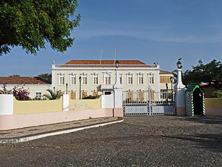
Quartel Jaime Mota is a historical building in the historic city centre (Plateau) of Praia, Cape Verde. It is situated at the southern end of Avenida Andrade Corvo, near the Presidential Palace of Cape Verde. It was built between 1823 and 1826 as a military barracks. The present structure in Neo-Manueline style dates from 1872, and was further expanded and modified in the late 19th and early 20th century. After independence, it was named after Jaime Mota, a Cape Verdean militant of PAIGC who was killed in Portuguese Guinea.
The island population were disadvantaged by the Portuguese colonial system and supported Amílcar Cabral and the African Party for the Independence of Guinea and Cape Verde, the first reviews related to its independence was Certeza and was a milestone in its national literature, the first edition was published in March 1944,[14] the second later in June.[15] and the last in January 1945,[16] afterwards it became banned by the censor.[17] a year later, a petition took place in Assomada and other parts of the island. Later in 1962, several of the first attacks ordered by the guerrillas of the PAIGC, this started the struggle against the oppression of Portugal, months later the Guinea-Bissau War of Independence broke out in Portuguese Guinea (now Guinea-Bissau), due to logistical reasons, Cape Verde didn't take part, in the same time in August, demonstrations took place over the imposing of another Minister of Overseas Possessions. Some of the opponents were jailed at Tarrafal Prison Camp in the north of the island. As was for all of Cape Verde, the final years of Portuguese rule were tyrannical and oppressive, some of the music genres of funaná and batuque were banned to be performed in cities especially the capital, the genre was not fully revived until the early 1990s. A few years before independence, a student revolt took place within Assomada and Praia in 1970. The greatest writer and poet from the island who had independence tendencies was Jorge Barbosa, who published work in the Claridade review. The Municipality of Santa Cruz was created from the east of Santa Catarina. The Carnation Revolution took place in Portugal and Cape Verde became an autonomous province and later headed to an independent country the following year.
Modern Santiago Island
Satellite view of Santiago except for the northern part in August 2002
Cape Verde declared independence on July 5, 1975 and Praia became the national capital. For several times, the island of Santiago hosted conferences on Creole culture.
The island which was deforested and featured a desert landscape went under reforestation program. Once covered only the highland areas in the late 1970s, slowly the middle and the eastern areas were forested in the 1980s and the 1990s and trees were planted in more of the east, the northernmost around Tarrafal, and the southernmost around RIbeira Grande in the 1990s and the 2000s, in 2010, the area around Rincão became partly forested.
The island especially underwent a large population boom which begun in the 1930s and grew additionally from the 1960s and continues into the present day. An airport was later built. The population was growing, the municipal administration cut off most of the rural northern part and São Domingos was created in 1988 thus changing the boundaries for the first time, it relieved Praia of the administrative difficulties involved in managing both a large capital city in addition to agrarian villages, the westerns village were exempted until 2005. In 1991, São Miguel split from Tarrafal and covers the southeastern portion.
Cape Verde's first botanical garden, the Jardim Botânico Nacional Grandvaux Barbosa, it currently forms a part of the University of Cape Verde. The Praia da Gambôa music festival was founded in 1992, Cape Verde's second after Baía das Gatas. More facilities and institutions were formed in the 1990s including the RTC in 1995, Praia's Museu Etnográfico in 1997 and the nation's library in 1999, the first superior educational institutions were established, the Jean Piaget University in 2001 and the University of Cape Verde in 2005. The Serra da Malagueta Natural Park was founded on February 24, 2003 and was the first national part created on the island, Pico da Antónia National Park was created not long after. Between 1976 and 2001, more sports clubs were formed and the Santiago Island Leagues of football (soccer) and basketball split up into the North and South zones in 2003, the south covered only the Municipality of Praia, it would contain two municipalities in 2005 as the Municipality of Ribeira Grande was formed, in 2010, clubs from the municipality of São Domingos joined the South Zone. Two more municipalities were formed in 2005, Ribeira Grande de Santiago which once covered the west of Praia and São Salvador do Mundo.
In 2006, Estádio da Várzea was renovated and enlarged. The Prime Minister visited the Rabelados inhabited areas of the island on February 6, 2007 especially the most dominant population in Espinho Branco.[18] The House of Marine and Sea Turtles was founded in 2008 in Praia Baixo in the northeast of São Domingos for the protection of the island's turtles.[19] Cidade Velha and its fortress were declared UNESCO World Heritage Site and the only heritage sites in Cape Verde.
The first of four dams that supply water to particularly agriculture and the city of Praia started construction in 2005, Poilão was the first project west of Pedra Badejo, the nation's first dam or reservoir, the next were three new dams, construction started in 2011 and were finished in 2013, some of the reservoirs are dry during dry conditions, the Salineiro dam north of Ribeira Grande was completed on June 30,[20] Faveta near Assomada on July 19[21] and Saquinho west of Assomada on October 30.[22]
In 2015 on Ilhéu de Santa Maria off the shores of Praia, the Cape Verdean government and Legend Development Company made a legal contract and proposes to construct hotel resort and casino, the cost is around 30 billion Cape Verdean escudos (250 million euros).[23]Hurricane Fred struck the island, its rains filled Barragem de Faveta (Faveta Reservoir) to maximum capacity and prompted residents from adjacent areas to evacuate.[24]
Demographics
The island's population unlike the north which most part was steadily growing and the west, it grew large, it was around 35,000 to 40,000 in 1900, the population steadily grew between 1940 and 1960, it grew to 107,624 in 1970 and reached 229,900 in 2000 at the turn of the century and continued to be 272,312 in 2010 and has reached over 300,000 in 2015, the island is home to around half of the country's population. Praia, in the 1900s once concentrated only within the plateau and sea, the urban area including its greenspace area later extended to Gambôa, Craveiro Lopes and the west, the north and in 2010 up to the eastern shore and recently the islet. Also the second largest place which since 2001 is a city quadrupled its population and nearly quintupled its built up area and the urban portion first reached the Circular Road near Ribeira da Trindade in around 2014. Of the cities in Macaronesia in the North Atlantic, Praia's metropolitan population superseded the Azores' Ponta Delgada's metro population somewhere around the 1990s, Praia has probably now become more populous than the city of Funchal in the Madeira Islands. Also Tarrafal grew and some of its housing developments spread to the eastern portion in 2001 and Pedra Badejo grew, its built up area has one portion having a bypass crossing that area.
Santa Catarina is a concelho (municipality) of Cape Verde. It is situated in the western part of the island of Santiago. Its seat is the city of Assomada. Its population was 45,920 in 2017 (estimate). Its area is 242.6 km2.
Santa Cruz is a concelho (municipality) of Cape Verde. It is situated in the eastern part of the island of Santiago. Its seat is the city Pedra Badejo. Its population was 26,617 at the 2010 census, and its area is 112.2 km2.
Pedra Badejo is a city in the eastern part of the island of Santiago, Cape Verde. It is situated on the east coast, 25 km north of the island capital Praia, 8 km southeast of Calheta de São Miguel and 15 km east of Assomada. It is the seat of Santa Cruz municipality. At the 2010 census, the town had 9,859 inhabitants.
Picos, also known as Achada Igreja, is a city in the central part of the island of Santiago, Cape Verde. It is the seat of São Salvador do Mundo municipality. Picos is located 4 km southeast of Assomada and 23 km northwest of the capital city of Praia, near the national road from Praia to Tarrafal via Assomada (EN1-ST01).
Achada Monte is a town in the northern part of the island of Santiago, Cape Verde and is part of the municipality of São Miguel. It is situated near the east coast, 8 km northwest of Calheta de São Miguel. In 2010 its population was 1,652. It is on the road connecting Praia and Tarrafal through Pedra Badejo, the EN1-ST02. The small bay Mangue de Sete Ribeiras is located east of the settlement. Ribeira Principal flows west of the village.
Tarrafal is a city in the northern part of the island of Santiago, Cape Verde. In 2010 its population was 6,656. It is a fishing port situated on the northwestern coast. It constitutes the seat of the Tarrafal Municipality.
João Teves is a city in the central part of the island of Santiago, Cape Verde. It is situated 19 km northwest of the capital Praia, on the national road from Praia to Assomada (EN1-ST01). It is the seat of São Lourenço dos Órgãos municipality. A source river of the Ribeira Seca flows through the town.
The Culture of the Island of Santiago, Cape Verde is the richest in the nation, with a range of customs and practices common in the islands,
The Architecture of Cape Verde has different architectural styles in the nation. Unlike the African mainland, Cape Verde was uninhabited until 1461 when the Portuguese arrived, most of the other islands were first inhabited after the end of the 15th century. Its architecture was introduced in the 1460s and has its first origins from Portuguese settlers from the Madeira Islands, after the first arrival of mainland Africans, a bit of African architecture would be elements mainly in rural areas. The Manueline was its first architectural style on the island, it was later followed by Renaissance, Baroque, Pombaline, Early Modern and Modern. It was one of the last in the whole of Africa to introduce architecture late. Cape Verde has one of the richest architecture in the western portion of West Africa, the sub-Saharan portion, the richest probably being Mali.
EN1-ST01 is a first class national road on the island of Santiago, Cape Verde. It runs from the capital Praia in the south to Tarrafal in the north, through the mountainous interior of the island. It is 61 km long. The main intersections are:
Veneza is a settlement in the northeastern part of the island of Santiago, Cape Verde. It is part of the municipality of São Miguel. It is a suburb of the city of Calheta de São Miguel, north of the city centre. It is situated on the coast, along the Praia-Pedra Badejo-Tarrafal Road (EN1-ST02). In 2010 its population was 1,375.
Ponta Verde is a seaside settlement in the northeastern part of the island of Santiago, Cape Verde. It is a suburb of the city of Calheta de São Miguel, part of the municipality of São Miguel. It is situated on the Praia-Pedra Badejo-Tarrafal Road (EN1-ST02), 1.5 km northwest of the centre of Calheta de São Miguel. In 2010 its population was 1,065.
São Martinho Grande is a settlement in the southern part of the island of Santiago, Cape Verde. It is part of the municipality Ribeira Grande de Santiago. It is located 4 km east from Cidade Velha and 6.5 km west of Praia city centre. The national road EN1-ST05 passes north of the village. 1.5 km south of the village is a small bay of the Atlantic Ocean, Calheta de São Martinho. It was mentioned as "Kalyete de S. Martin" on the 1747 map by Jacques-Nicolas Bellin.
References
↑ Island Boulders Reveal Ancient Megatsunami, Nature, Retrieved 2015-10-06
↑ Michel Cahen (dir.), "Vilas" et "cidades" : bourgs et villes en Afrique lusophone (preface by Catherine Coquery-Vidrovitch), L'Harmattan, Paris, 1989, p. 30 ISBN2-7384-0431-6
↑ "Nobreza de Portugal e do Brasil", Direcção de Afonso Eduardo Martins Zúquete, Editorial Enciclopédia, 2.ª Edição, Lisboa, 1989, Volume Terceiro, p. 320
Avezac, Armand (1848). Sao-Thiago. L'Univers. Îles de l'Afrique (in French). Paris: Firmin Didot frères. pp.201–205.
T. B. Duncan, Atlantic Islands: Madeira, the Azores, and the Cape Verdes in Seventeenth-Century Commerce and Navigation, University of Chicago Press, 1972
Keeler, Mary Frear (1999). Sir Francis Drake's West Indian Voyage, 1585-86 (Second Series). Hakluyt Society. ISBN978-0904180015.
Konstam, Angus (2011). The Great Expedition: Sir Francis Drake on the Spanish Main - 1585-86 (Raid). Osprey Pub. ISBN978-1849082457.
Maria Elizabeth Lucas and Sergio Baptista da Silva (dir.), Ensaios etnográficos na ilha de Santiago de Cabo Verde: processos identitários na contemporaneidade (Ethnographic Essays on the Island of Santiago, Cape Verde), Edições Uni-CV, Praia ; Editora da UFRGS, Porto Alegre, 2009, 277 pages ISBN978-989-96130-2-7(in Portuguese)
Eugene Tavares (2009). Littératures lusophones des archipels atlantiques: Açores, Madère, Cap-Vert, São Tomé e Príncipe'[Lusophony Literature in the Atlantic Archipelagoes: Azores, Madeira, Cape Verde and São Tomé and Príncipe]. L'Harmattan. ISBN9782296075757.
This page is based on this Wikipedia article Text is available under the CC BY-SA 4.0 license; additional terms may apply. Images, videos and audio are available under their respective licenses.