Monte das Vacas

Last updated
Monte das Vacas
Cape Verde location map Topographic.png
Red triangle with thick white border.svg
Monte das Vacas
northern Santiago
Highest point
Elevation 437 m (1,434 ft)
Listing List of mountains in Cape Verde
Coordinates 14°59′32″N23°32′20″W / 14.9923°N 23.5390°W / 14.9923; -23.5390 Coordinates: 14°59′32″N23°32′20″W / 14.9923°N 23.5390°W / 14.9923; -23.5390
Geography
Location northern Santiago
Geology
Age of rock Miocene and Pliocene
Mountain type Stratovolcano
Type of rock basalt, basanite
Climbing
Easiest route climb

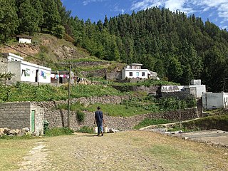
Monte das Vacas is a mountain located in the southeastern part of the island of Santiago, Cape Verde 8 km from the capital Praia, north of the subdivision of Achada de São Filipe and southwest of Ribeirão Chiqueiro. Its elevation is 437 meters. From its base it is around 150 meters from the plateau at an elevation of 180 meters.

Mountain A large landform that rises fairly steeply above the surrounding land over a limited area

A mountain is a large landform that rises above the surrounding land in a limited area, usually in the form of a peak. A mountain is generally steeper than a hill. Mountains are formed through tectonic forces or volcanism. These forces can locally raise the surface of the earth. Mountains erode slowly through the action of rivers, weather conditions, and glaciers. A few mountains are isolated summits, but most occur in huge mountain ranges.

Santiago, Cape Verde largest island of Cape Verde

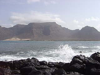
Santiago is the largest island of Cape Verde, its most important agricultural centre and home to half the nation’s population. Part of the Sotavento Islands, it lies between the islands of Maio and Fogo. It was the first of the islands to be settled: the town of Ribeira Grande was founded in 1462. Santiago is home to the nation's capital city of Praia.

Cape Verde Country comprising ten islands off the Northwest coast of Africa

Cape Verde or Cabo Verde, officially the Republic of Cabo Verde, is an island country spanning an archipelago of 10 volcanic islands in the central Atlantic Ocean. It forms part of the Macaronesia ecoregion, along with the Azores, Canary Islands, Madeira, and the Savage Isles. In ancient times these islands were referred to as "the Islands of the Blessed" or the "Fortunate Isles". Located 570 kilometres (350 mi) west of the Cape Verde Peninsula off the coast of Northwest Africa, the islands cover a combined area of slightly over 4,000 square kilometres (1,500 sq mi).

Contents

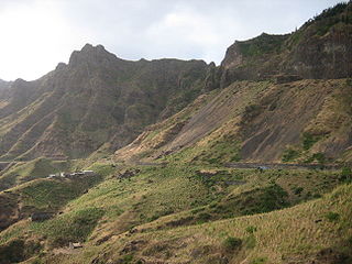
The mountain is of volcanic origin and is made up of what was a large volcanic crater, once a subsidiary vent, it was not often erupted as in Pico da Antónia millions of years ago. Only the southwest part remains along with bits of the northeast while the remainder are eroded.

Most of the mountain is in the Praia, the northernmost part is in São Domingos with the boundaries going east-west at the mid north part. Less than a kilometer north is the 15th parallel north. East is the Praia-Tarrafal Route, the EN1-ST01 (Primary Route 1) and west is Ribeira da Veneza with its settlement in the southwest. South is the source of Ribeira de São Filipe, a small stream that empties into Ribeira da Trindade just short of Praia Harbour.

Praia, Cape Verde (municipality) Municipality in Santiago, Cape Verde

Praia is a concelho (municipality) of Cape Verde. It is situated in the southern part of the island of Santiago. Its seat is the city Praia, the capital of Cape Verde. Its area is 120.6 km2 (46.6 sq mi), and its population was 131,719 at the 2010 census. The municipality consists of one freguesia, Nossa Senhora da Graça. The city hall is located in the Platô part of the city.

São Domingos, Cape Verde (municipality) Municipality in Santiago, Cape Verde

São Domingos is a concelho (municipality) of Cape Verde. It is situated in the southeastern part of the island of Santiago. Its seat is the city São Domingos. Its population was 13,699 at the 2010 census, and its area is 147.5 km2.

15th parallel north circle of latitude

The 15th parallel north is a circle of latitude that is 15 degrees north of the Earth's equatorial plane. It crosses Africa, Asia, the Indian Ocean, the Pacific Ocean, Central America, the Caribbean and the Atlantic Ocean.

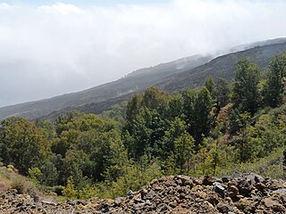
Surrounding the mountains, the outer areas are forested but the middle portion are grassland. Before settlements appeared at the 15th century, it was believed to be dominated by shrubs, decades later, it became mostly a barren grassland.

Its geology consists of the Monte das Vacas formation spreading across the southeast portion of the island and including much of its hills, it was formed between 1 million to 700,000 years ago. [1]

During the Ice Age, its elevation was about 567 meters, at around 10000 BC, the elevation was at 500 meters, up to about 4000 BC, the elevation was at 450 meters.

Panoramics

The mountain can be seen in most parts of Praia, in areas by the sea and the uppermost parts, also it can be seen in the area of Ribeira Grande de Santiago and the south of São Domingos Municipality.

See also

Related Research Articles

Geography of Cape Verde

Cape Verde is a group of arid Atlantic islands which are home to a number of birds and reptiles and constitute a unique ecoregion in the World Wildlife Fund classification.

Boa Vista, Cape Verde Cape Verde island

Boa Vista, also written as Boavista, is a desert-like island that belongs to the Cape Verde Islands. At 631.1 km2 (243.7 sq mi), it is the third largest island of the Cape Verde archipelago.

Monte Verde, Cape Verde mountain

Monte Verde is a mountain in the eastern part of the island of São Vicente, Cape Verde. At 744 m elevation, it is the island's highest point. The mountain is located 6 km (4 mi) east of the city centre of Mindelo.

Tope de Coroa mountain in Cape Verde

Tope de Coroa is a mountain on the island of Santo Antão's, Cape Verde. At 1,979 m elevation, it is the highest point of the island. It is in the western part of the island, 25 km west of the island capital Porto Novo. The mountain is entirely of volcanic origin. The area is the source of several streams including Ribeira de Monte Trigo which flows westward to Monte Trigo.

Monte Gordo, Cape Verde mountain on the island of São Nicolau, Cape Verde

Monte Gordo is a mountain on the island of São Nicolau, Cape Verde. At 1,312 m elevation, it is the island's highest point. It is situated in the western part of the island, 6 km west of the island capital Ribeira Brava. The mountain is of volcanic origin, less than 1 million years old. The boundary of the municipalities Tarrafal de São Nicolau and Ribeira Brava runs over the mountain. It is part of the Monte Gordo Natural Park.

Monte Penoso mountain in Cape Verde

Monte Penoso is a mountain on the island of Maio, Cape Verde. At 436 m elevation, it is the island highest point. It is situated in the eastern part of the island, 3 km southwest of Pedro Vaz and 13 km northeast of the island capital Porto Inglês. The mountain is of volcanic origin. It is part of the protected landscape Monte Penoso and Monte Branco, which covers 11.17 km2 (4.31 sq mi).

Pico de Antónia mountain in Cape Verde

Pico de Antónia is a mountain located in the central part of the island of Santiago in Cape Verde. At 1,392 m (4,567 ft), it is the highest point of the island. The mountain is part of the protected area Parque Natural da Serra do Pico de Antónia. The towns Picos and Assomada lie close to the mountain. The Serra do Pico da Antónia has been identified by BirdLife International as an Important Bird Area.

Monte Bissau mountain in Cape Verde

Monte Bissau is a mountain in the central part of the island of São Nicolau in Cape Verde. It is situated 3 km southwest of Belém and 6 km east of the island capital Ribeira Brava. Its elevation is 615 m.

Serra Malagueta mountain in Cape Verde

Serra Malagueta is a mountain range located in the northern part of the island of Santiago, Cape Verde. At 1064 m elevation, it is highest point of northern Santiago. The mountain range is protected as the Serra Malagueta Natural Park, that was established on February 24, 2005 and covers 774 hectares. The natural park is situated in the municipalities Tarrafal, São Miguel and Santa Catarina. The summit is in São Miguel, south of the Ribeira Principal valley. The Serra Malagueta formation is of volcanic origin, and was formed between 2.9 and 2.4 million years ago.

Monte Batalha mountain in Cape Verde

Monte Batalha is a mountain in the island of Maio in Cape Verde. Its elevation is 294 m. It is situated 4 km southeast of Calheta and 8 km northeast of the island capital Porto Inglês.

Serra Negra, Cape Verde mountain in Cape Verde

Serra Negra is a hill in the southeastern part of the island of Sal in Cape Verde. Its maximum elevation is 104 m, the highest point in southern Sal. It stretches for about 2.5 km along the east coast of the island, between the headland Ponta da Fragata in the south and the Ponta do Morrinho Vermelho in the north. The nearest settlement is Murdeira, to the west. The mountain forms part of a protected area as a nature reserve, important as nesting area for seabirds and turtles. The nature reserve covers 3.31 km2 (1.28 sq mi) of land and 22.96 km2 (8.86 sq mi) of ocean.

Monte Grande (Sal) mountain in Cape Verde

Monte Grande is a mountain in the northern part of the island of Sal in Cape Verde. It is situated 8 km northeast of the island capital Espargos. At 406 m elevation, it is the highest point of the island. It is a protected landscape because of its geological value; the protected area covers 1,309 ha. There are pillow lava formations on the coast.

Ponta da Fragata

Ponta da Fragata is a headland on the east coast of the island of Sal, Cape Verde. It is situated at the southern end of the Serra Negra mountain, 6 km northeast of the town Santa Maria. To the south of the headland stretches the Costa da Fragata, a 4.7 km long sandy beach which is a protected nature reserve, important as nesting area for loggerhead sea turtles. The nature reserve covers 3.46 km2 (1.34 sq mi) of land and 23.47 km2 (9.06 sq mi) of ocean.

Monte Velha mountain in Cape Verde

Monte Velha is a peak in the northeastern part of the island of Fogo in Cape Verde. Its elevation is 1,482 m. It is a subpeak of the Pico do Fogo volcano, located at the northeastern end of the crater rim. It lies within the municipality of Mosteiros, 4 km southwest of the city centre. Its forest is a protected area, part of the larger Fogo Natural Park.

Pico da Cruz (village) Settlement in Santo Antão, Cape Verde

Pico da Cruz is a settlement in the northeastern part of the island of Santo Antão, Cape Verde. In 2010 its population was 138. It is situated 6 km southwest of Pombas and 10 km northeast of the island capital Porto Novo. Its elevation is about 1,400 meters. The village is named after the nearby mountain Pico da Cruz. It lies in the Cova-Paul-Ribeira da Torre Natural Park.

Morrinho de Açúcar

Morrinho de Açúcar is a small hill in the northern part of the island of Sal in Cape Verde. It is situated 1 km from the north coast and 8 km north of the island capital Espargos. It is a remnant of a volcanic phonolitic chimney, surrounded by a vast plain. It is protected as a natural monument.

Monte António Gomes mountain in Cape Verde

Monte António Gomes is a mountain in the northeastern part of the island of São Vicente, Cape Verde. Its elevation is 362 meters. It is 1.6 km north of Monte Verde, 2.3 km southeast of the village Salamansa and 6 km east of the city centre of Mindelo.

Monte Tchota

Monte Tchota is a mountain located in the central part of Santiago Island in Cape Verde. Its elevation is 1,041 m. It is part of the Serra do Pico de Antónia Natural Park, and lies 1.5 km southeast of Pico de Antónia, the highest point of the island. The village Rui Vaz lies 3 km to the east.

References

  1. Holm, P. M. (2008). An 40Ar-39Ar study of the Cape Verde hot spot: temporal evolution in a semistationary plate environment. 113. J. Geophys. Res. p. B08201.