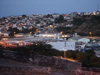
Nelson Mandela International Airport, also known as Praia International Airport, is the airport of Santiago Island in Cape Verde. It was opened in October 2005, replacing the old Francisco Mendes International Airport. It is located about 3 km northeast of the city centre of Praia in the southeastern part of the island of Santiago.

Estádio Municipal Adérito Sena is a multi-use stadium in Mindelo, Cape Verde. It is currently used mostly for football matches and is the home stadium of FC Derby as well as CS Mindelense, Académica, GD Amarantes and Batuque FC and the lesser club of Corinthians São Vicente. The stadium holds 5,000 people and area is 105x68 m and its ground is artificial grass. The stadium is owned by the municipality of São Vicente and is operated by the São Vicente Regional Football Association (ARFSV). It is a certified stadium by FIFA for international competition as well as friendly matches

Achadinha is a subdivision of the city of Praia in the island of Santiago, Cape Verde. Its population was 8,483 at the 2010 census. It is situated north of the city centre. Adjacent neighbourhoods include Bairro Craveiro Lopes to the south, Fazenda in the east, Achada Eugênio Lima in the west and Calabaceira in the north, on the other side of the Ribeira da Trindade.

Povoação Velha is a village in the southwestern part of the island of Boa Vista, Cape Verde. The village is around 16 km south of the island capital Sal Rei.
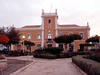
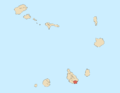
Praia is a concelho (municipality) of Cape Verde. It is situated in the southern part of the island of Santiago. Its seat is the city Praia, the capital of Cape Verde. Its area is 120.6 km2 (46.6 sq mi), and its population was 131,719 at the 2010 census. The municipality consists of one freguesia, Nossa Senhora da Graça. The city hall is located in the Platô part of the city.

Farol de Dona Maria Pia is a lighthouse at the southernmost point of the island of Santiago, Cape Verde. It stands on the headland Ponta Temerosa, at the entrance of Praia Harbour, 2 km south of the city centre of Praia. The lighthouse was built in 1881 and was named after Maria Pia of Savoy, queen of Portugal at the time. The octagonal tower is 21 m high and its focal plane is 25 m above mean sea level. It is painted white. The lighthouse is used for navigational purposes.

Quartel Jaime Mota is a historical building in the historic city centre (Plateau) of Praia, Cape Verde. It is situated at the southern end of Avenida Andrade Corvo, near the Presidential Palace of Cape Verde. It was built between 1823 and 1826 as a military barracks. The present structure in Neo-Manueline style dates from 1872, and was further expanded and modified in the late 19th and early 20th century. After independence, it was named after Jaime Mota, a Cape Verdean militant of PAIGC who was killed in Portuguese Guinea.
Praia Baixo is a village in the southeastern part of the island of Santiago, Cape Verde. It is part of the municipality of São Domingos and the parish of Nossa Senhora da Luz. It is situated on the east coast, 1.5 km northwest of Achada Baleia, 11 km southeast of Pedra Badejo, 10 km east of São Domingos and 16 km north of the capital Praia. In 2010 its population was 952.
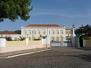
Plateau is the historic centre of the capital city of Praia in the island of Santiago, Cape Verde. It gets its name because it is situated on a plateau overlooking the port of Praia. Its average elevation is 37 meters above sea level. The population of Plateau was 1,019 at the 2010 census. Many public buildings are situated in Plateau, notably the Presidential Palace, the cathedral, the city hall and the Ethnographic Museum.
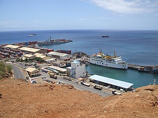
Praia Harbor is the port of the city of Praia in the southern part of the island of Santiago, Cape Verde. It is situated in a natural bay of the Atlantic Ocean. Since the latest modernization in 2014, it has 2 long quays, 3 shorter quays, a quay for fishing boats with fish processing installations, 2 container parks, 2 roll-on/roll-off ramps and a passenger terminal. The total length of the quays is 863 m, and the maximum depth is 13.5 m. The port of Praia played an important role in the colonization of Africa and South America by the Portuguese. With 817,845 metric tonnes of cargo and 85,518 passengers handled (2017), it is the second busiest port of Cape Verde, after Porto Grande (Mindelo).
Lem Ferreira is a subdivision of the city of Praia in the island of Santiago, Cape Verde. Its population was 1,456 at the 2010 census. It is situated directly east of the city centre (Platô), on the east bank of Ribeira da Trindade. Bordering neighborhoods include Agua Funda to the northeast, Achada Grande Frente to the east and the south and Platô and Praia Negra to the west.
The Culture of the Island of Santiago, Cape Verde is the richest in the nation, with a range of customs and practices common in the islands,

Fazenda is a subdivision of the city of Praia in the island of Santiago, Cape Verde. Its population was 1,848 at the 2010 census. It is situated directly north of the city centre (Platô). Bordering neighbourhoods include Lem Cachorro to the northeast, Paiol to the east, Platô to the south and Achadinha to the west. Its northern and eastern borders are formed by Ribeira da Trindade.
The Architecture of Cape Verde has different architectural styles in the nation. Unlike the African mainland, Cape Verde was uninhabited until 1461 when the Portuguese arrived, most of the other islands were first inhabited after the end of the 15th century. Its architecture was introduced in the 1460s and has its first origins from Portuguese settlers from the Madeira Islands, after the first arrival of mainland Africans, a bit of African architecture would be elements mainly in rural areas. The Manueline was its first architectural style on the island, it was later followed by Renaissance, Baroque, Pombaline, Early Modern and Modern. It was one of the last in the whole of Africa to introduce architecture late. Cape Verde has one of the richest architecture in the western portion of West Africa, the sub-Saharan portion, the richest probably being Mali.

Ribeira Seca is the largest stream of the island of Santiago in Cape Verde. It is 18 km (11 mi) long and its basin area is 71.5 km2 (27.6 sq mi). Located in the eastern part of the island, it flows through the municipalities of São Lourenço dos Órgãos and Santa Cruz. Its source is near the highest point of the island, Pico de Antónia, from where it flows to the east to João Teves. It turns to the northeast and flows into the Atlantic Ocean at Achada Fazenda, 2 km southeast of Pedra Badejo. It is called Ribeira de Pico da Antónia in its uppermost part, and Ribeira de Lage near João Teves.

Praia de Santa Maria is a beach on the south coast of the island of Sal, Cape Verde. It stretches from the city center of Santa Maria in the east to the Ponta do Sinó in the southwest. It is about 2 km long. Along with Praia da Ponta Preta, it is the most popular beach on the city and island.
Calabaceira is a subdivision of the city of Praia in the island of Santiago, Cape Verde. Its population was 4,582 at the 2010 census. It is situated northwest of the city centre, on the north bank of Ribeira da Trindade. Adjacent neighbourhoods include Vila Nova to the east, Achadinha to the south, Pensamento to the west and Safende to the north.
Vila Nova is a subdivision of the city of Praia in the island of Santiago, Cape Verde. Its population was 4,868 at the 2010 census. It is situated north of the city centre. Adjacent neighbourhoods are Safende to the north, Ponta de Água to the east, Lem Cachorro to the southeast, Achadinha to the south and Calabaceira to the west. Ribeira da Trindade forms its southern border.