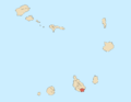
Calheta de São Miguel is a city in the northern part of the island of Santiago, Cape Verde. In 2010 its population was 3,175. It is situated on the east coast, 31 km north of the capital Praia. It is the seat of São Miguel municipality.

São Lourenço dos Órgãos is a concelho (municipality) of Cape Verde. It is situated in the mountainous central part of the island of Santiago. Its seat is the city João Teves. Its population was 7,388 at the 2010 census, and its area is 36.9 km2. The municipality is bordered by Santa Cruz to the northeast, São Domingos to the south, Ribeira Grande de Santiago to the southwest and São Salvador do Mundo to the northwest. Pico de Antónia, the island's highest mountain, straddles the borders of São Lourenço dos Órgãos, São Salvador do Mundo and Ribeira Grande de Santiago.

São Salvador do Mundo is a concelho (municipality) of Cape Verde. It is situated in the central part of the island of Santiago. Its seat is the city Picos. Its population was 8,677 at the 2010 census, and its area is 26.5 km2, making it the smallest municipality of Cape Verde. The municipality borders Santa Cruz to the northeast, São Lourenço dos Órgãos to the southeast, Ribeira Grande de Santiago to the southwest and Santa Catarina to the northwest.

Boa Entrada is a settlement in the central part of the island of Santiago, Cape Verde. In 2010 its population was 1,119. It is situated 2 km north of Assomada city centre. The area is intensively cultivated, especially with sugarcane and mango trees.

Achadinha is a subdivision of the city of Praia in the island of Santiago, Cape Verde. Its population was 8,483 at the 2010 census. It is situated north of the city centre. Adjacent neighbourhoods include Bairro Craveiro Lopes to the south, Fazenda in the east, Achada Eugênio Lima in the west and Calabaceira in the north, on the other side of the Ribeira da Trindade.
São Francisco is a subdivision of the city of Praia in the island of Santiago, Cape Verde. Its population was 570 at the 2010 census. It is situated 7 km north of the city centre. 3.5 km to its east is the São Francisco Bay, and 2.5 km to its northeast the village Vale da Custa, part of the municipality of São Domingos.
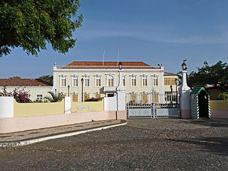
Plateau is the historic centre of the capital city of Praia in the island of Santiago, Cape Verde. It gets its name because it is situated on a plateau overlooking the port of Praia. Its average elevation is 37 meters above sea level. The population of Plateau was 1,019 at the 2010 census. Many public buildings are situated in Plateau, notably the Presidential Palace, the cathedral, the city hall and the Ethnographic Museum.

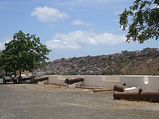
Chã de Areia is a subdivision of the city of Praia in the island of Santiago, Cape Verde. Its population was 247 at the 2010 census. It is situated south and west of the city centre. Adjacent neighbourhoods include Plateau to the northeast, Achadinha to the north, Várzea to the west, Achada Santo António to the southwest and Prainha to the south. Its main streets are Avenida Combatentes da Liberdade da Patria and Avenida Cidade de Lisboa. Points of interest in Chã de Areia include the beach of Gamboa, the old port of Praia and the Cape Verdean National Archives, housed in the former customs building.

Achada Santo António is a subdivision of the city of Praia in the island of Santiago, Cape Verde. Its population was 12,965 at the 2010 census. It is situated near the Atlantic coast, southwest of the city centre.

Várzea is a subdivision of the city of Praia in the island of Santiago, Cape Verde. Its population was 4,834 at the 2010 census. It is situated west of the city centre. Adjacent neighbourhoods are Bairro Craveiro Lopes to the north, Platô to the east, Achada Santo António to the south and Terra Branca to the west.

Achada Grande Tras is a subdivision of the city of Praia in the island of Santiago, Cape Verde. Its population was 2,958 at the 2010 census. It is situated east of the city centre, and south of the Nelson Mandela International Airport. Adjacent neighbourhoods include Achada Grande Frente and Lem Ferreira to the west.

Prainha is a subdivision of the city of Praia in the island of Santiago, Cape Verde. Its population was 309 at the 2010 census. It is situated on the coast, south of the city centre. Adjacent neighbourhoods are Achada Santo António to the north and Quebra Canela to the west. Several foreign embassies are located in Prainha.

Quebra Canela is a subdivision of the city of Praia in the island of Santiago, Cape Verde. Its population was 19 at the 2010 census. It is situated southwest of the city centre. Adjacent neighbourhoods are Palmarejo to the west, Achada Santo António to the north and Prainha to the east. It has a popular beach.
Achada Grande Frente is a subdivision of the city of Praia in the island of Santiago, Cape Verde. Its population was 4,436 at the 2010 census. It is situated east of the city centre, between the Praia Harbour to the south and the Nelson Mandela International Airport to the north. The former Francisco Mendes International Airport was located in Achada Grande Frente.

Palmarejo is a subdivision of the city of Praia in the island of Santiago, Cape Verde. Its population was 12,037 at the 2010 census. It is situated southwest of the city centre. Adjacent neighbourhoods are Tira Chapéu to the north, Achada Santo António in the east, Quebra Canela in the southeast, Cidadela in the west and Palmarejo Grande in the northwest. The main campus of the University of Cape Verde is located in Palmarejo.

Fazenda is a subdivision of the city of Praia in the island of Santiago, Cape Verde. Its population was 1,848 at the 2010 census. It is situated directly north of the city centre (Platô). Bordering neighbourhoods include Lem Cachorro to the northeast, Paiol to the east, Platô to the south and Achadinha to the west. Its northern and eastern borders are formed by Ribeira da Trindade.
Bairro Craveiro Lopes is a subdivision of the city of Praia in the island of Santiago, Cape Verde. Its population was 1,519 at the 2010 census. It is situated northwest of the city centre. Adjacent neighbourhoods include Achadinha to the north, Fazenda to the east, Várzea to the south and Achada Eugénio Lima to the northwest.
Ponta de Água is a subdivision of the city of Praia in the island of Santiago, Cape Verde. Its population was 8,682 at the 2010 census. It is situated 2 km north of the city centre. Adjacent neighbourhoods are Monteagarro to the north, Coqueiro/Castelão to the east, Lem Cachorro to the south, Vila Nova to the southwest and Safende to the west.
Veneza is a settlement in the northeastern part of the island of Santiago, Cape Verde. It is part of the municipality of São Miguel. It is a suburb of the city of Calheta de São Miguel, north of the city centre. It is situated on the coast, along the Praia-Pedra Badejo-Tarrafal Road (EN1-ST02). In 2010 its population was 1,375.
Calabaceira is a subdivision of the city of Praia in the island of Santiago, Cape Verde. Its population was 4,582 at the 2010 census. It is situated northwest of the city centre, on the north bank of Ribeira da Trindade. Adjacent neighbourhoods include Vila Nova to the east, Achadinha to the south, Pensamento to the west and Safende to the north.