Timeline of Santiago, Cape Verde

Last updated
Part of a series on the
History of Cape Verde
Flag-map of Cape Verde.svg
Colonial history
Independence struggle
Flag of Cape Verde.svg Cape Verdeportal

The following is a timeline of the island of Santiago, Cape Verde .

Santiago, Cape Verde largest island of Cape Verde

Santiago is the largest island of Cape Verde, its most important agricultural centre and home to half the nation’s population. Part of the Sotavento Islands, it lies between the islands of Maio and Fogo. It was the first of the islands to be settled: the town of Ribeira Grande was founded in 1462. Santiago is home to the nation's capital city of Praia.

Contents

Prehistoric and precolonial era

The Pliocene Epoch is the epoch in the geologic timescale that extends from 5.333 million to 2.58 million years BP. It is the second and youngest epoch of the Neogene Period in the Cenozoic Era. The Pliocene follows the Miocene Epoch and is followed by the Pleistocene Epoch. Prior to the 2009 revision of the geologic time scale, which placed the four most recent major glaciations entirely within the Pleistocene, the Pliocene also included the Gelasian stage, which lasted from 2.588 to 1.806 million years ago, and is now included in the Pleistocene.

The Zanclean is the lowest stage or earliest age on the geologic time scale of the Pliocene. It spans the time between 5.332 ± 0.005 Ma and 3.6 ± 0.005 Ma. It is preceded by the Messinian age of the Miocene epoch, and followed by the Piacenzian age.

The Piacenzian is in the international geologic time scale the upper stage or latest age of the Pliocene. It spans the time between 3.6 ± 0.005 Ma and 2.588 ± 0.005 Ma. The Piacenzian is after the Zanclean and is followed by the Gelasian.

Colonial era

Drake at Santiago, Cape Verde, 1589 hand-colored engraving, by Baptista Boazio, 1589 Santiago, Cape Verde, 1589.jpg
Drake at Santiago, Cape Verde, 1589 hand-colored engraving, by Baptista Boazio, 1589
Santiago Island, a 1647 painting by Caspar Schmalkalden Sanct Jago, auf derselben Insel - Caspar Schmalkalden.jpg
Santiago Island, a 1647 painting by Caspar Schmalkalden
Cidade Velha Settlement in Santiago, Cape Verde

Cidade Velha is a city in the southern part of the island of Santiago, Cape Verde. Founded in 1462, it is the oldest settlement in Cape Verde and its former capital. Once called Ribeira Grande, its name was changed to Cidade Velha in the late 18th century. It is the seat of the Ribeira Grande de Santiago municipality.

Portuguese Cape Verde former colony of the Portuguese Empire in the Cape Verde Islands

Cape Verde was a colony of the Portuguese Empire from the initial settlement of the Cape Verde Islands in 1462 until the independence of Cape Verde in 1975.

Nossa Senhora do Rosário church (Cidade Velha) Church in Santiago Island, Cape Verde

Nossa Senhora do Rosario church is a 15th century church in the town of Cidade Velha on the island of Santiago, Cape Verde. It is located in the northwest of the town, near the right (west) bank of the stream Ribeira Grande de Santiago. The historic centre of Cidade Velha is an UNESCO World Heritage site since June 2009.

After independence in 1975-1999

21st century

See also

History page:
Timeline by city or municipality:
Other island timeline articles in Cape Verde:

Related Research Articles

Santa Catarina, Cape Verde Municipality in Santiago, Cape Verde

Santa Catarina is a concelho (municipality) of Cape Verde. It is situated in the western part of the island of Santiago. Its seat is the city of Assomada. Its population was 45,920 in 2017 (estimate). Its area is 242.6 km2.

Santa Cruz, Cape Verde Municipality in Santiago, Cape Verde

Santa Cruz is a concelho (municipality) of Cape Verde. It is situated in the eastern part of the island of Santiago. Its seat is the city Pedra Badejo. Its population was 26,617 at the 2010 census, and its area is 112.2 km2.

Pedra Badejo Settlement in Santiago, Cape Verde

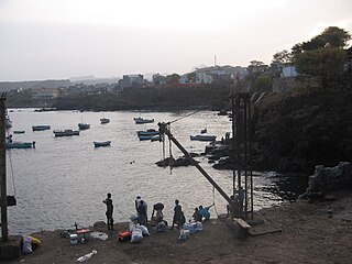
Pedra Badejo is a city in the eastern part of the island of Santiago, Cape Verde. It is situated on the east coast, 25 km north of the island capital Praia, 8 km southeast of Calheta de São Miguel and 15 km east of Assomada. It is the seat of Santa Cruz municipality. At the 2010 census, the town had 9,859 inhabitants.

Picos, Cape Verde Settlement in Santiago, Cape Verde

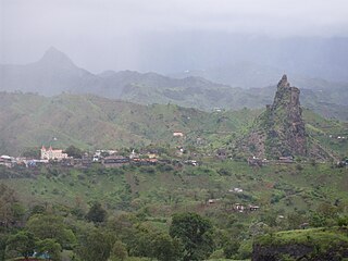
Picos, also known as Achada Igreja, is a city in the central part of the island of Santiago, Cape Verde. It is the seat of São Salvador do Mundo municipality. Picos is located 4 km southeast of Assomada and 23 km northwest of the capital city of Praia, near the national road from Praia to Tarrafal via Assomada (EN1-ST01).

Achada Monte Settlement in Santiago, Cape Verde

Achada Monte is a town in the northern part of the island of Santiago, Cape Verde and is part of the municipality of São Miguel. It is situated near the east coast, 8 km northwest of Calheta de São Miguel. In 2010 its population was 1,652. It is on the road connecting Praia and Tarrafal through Pedra Badejo, the EN1-ST02. The small bay Mangue de Sete Ribeiras is located east of the settlement. Ribeira Principal flows west of the village.

Tarrafal, Cape Verde Settlement in Santiago, Cape Verde

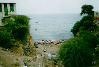
Tarrafal is a city in the northern part of the island of Santiago, Cape Verde. In 2010 its population was 6,656. It is a fishing port situated on the northwestern coast. It constitutes the seat of the Tarrafal Municipality.

João Teves Settlement in Santiago, Cape Verde

João Teves is a city in the central part of the island of Santiago, Cape Verde. It is situated 19 km northwest of the capital Praia, on the national road from Praia to Assomada (EN1-ST01). It is the seat of São Lourenço dos Órgãos municipality. A source river of the Ribeira Seca flows through the town.

The Culture of the Island of Santiago, Cape Verde is the richest in the nation, with a range of customs and practices common in the islands,

Architecture of Cape Verde

The Architecture of Cape Verde has different architectural styles in the nation. Unlike the African mainland, Cape Verde was uninhabited until 1461 when the Portuguese arrived, most of the other islands were first inhabited after the end of the 15th century. Its architecture was introduced in the 1460s and has its first origins from Portuguese settlers from the Madeira Islands, after the first arrival of mainland Africans, a bit of African architecture would be elements mainly in rural areas. The Manueline was its first architectural style on the island, it was later followed by Renaissance, Baroque, Pombaline, Early Modern and Modern. It was one of the last in the whole of Africa to introduce architecture late. Cape Verde has one of the richest architecture in the western portion of West Africa, the sub-Saharan portion, the richest probably being Mali.

EN1-ST01 road in Cape Verde

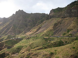
EN1-ST01 is a first class national road on the island of Santiago, Cape Verde. It runs from the capital Praia in the south to Tarrafal in the north, through the mountainous interior of the island. It is 61 km long. The main intersections are:

Veneza Settlement in Santiago, Cape Verde

Veneza is a settlement in the northeastern part of the island of Santiago, Cape Verde. It is part of the municipality of São Miguel. It is a suburb of the city of Calheta de São Miguel, north of the city centre. It is situated on the coast, along the Praia-Pedra Badejo-Tarrafal Road (EN1-ST02). In 2010 its population was 1,375.

Ponta Verde (Santiago) Settlement in Santiago, Cape Verde

Ponta Verde is a seaside settlement in the northeastern part of the island of Santiago, Cape Verde. It is a suburb of the city of Calheta de São Miguel, part of the municipality of São Miguel. It is situated on the Praia-Pedra Badejo-Tarrafal Road (EN1-ST02), 1.5 km northwest of the centre of Calheta de São Miguel. In 2010 its population was 1,065.

São Martinho Grande Settlement in Santiago, Cape Verde

São Martinho Grande is a settlement in the southern part of the island of Santiago, Cape Verde. It is part of the municipality Ribeira Grande de Santiago. It is located 4 km east from Cidade Velha and 6.5 km west of Praia city centre. The national road EN1-ST05 passes north of the village. 1.5 km south of the village is a small bay of the Atlantic Ocean, Calheta de São Martinho. It was mentioned as "Kalyete de S. Martin" on the 1747 map by Jacques-Nicolas Bellin.

References

  1. 1 2 3 4 Holm, P. M. (2008). An 40Ar-39Ar study of the Cape Verde hot spot: temporal evolution in a semistationary plate environment. 113. J. Geophys. Res. p. B08201.
  2. Brown, Emma (2 October 2015). "Island Boulders Reveal Ancient Megatsunami". Nature. Retrieved 2015-10-06.
  3. Ramalho, Ricardo S.; Winckler, Gisela; Madeira, José; Helffrich, George R.; Hipólito, Ana; Quartau, Rui; Adena, Katherine; Schaefer, Joerg M. (2 October 2015), "Hazard potential of volcanic flank collapses raised by new megatsunami evidence", Science Advances, vol. 1 no. 9, doi:10.1126/sciadv.1500456
  4. "Solar eclipse of March 28, 5 AD BC". NASA. Retrieved March 14, 2017.
  5. "Solar eclipse of January 5, 75 AD". NASA. Retrieved March 11, 2017.
  6. 1 2 Petit-futé Cap-Vert (Small Smart Cape Verde), 2015, p. 207
  7. Keeler, Mary Frear (1999). Sir Francis Drake's West Indian Voyage, 1585-86 (Second Series). Hakluyt Society. ISBN   978-0904180015.
  8. Sudgen, John (2004). Sir Francis Drake. Penguin Books. pp. 185–86. ISBN   978-1844137626.
  9. "A Published Diary About her Life" (in Dutch).
  10. "Travel Journal of Jan Frans Michel (written on November 14, 1752)" (in Dutch).
  11. "Cidade Velha, Santiago, Cape Verde Islands". CapeVerdeWeb.com. Retrieved 2009-05-28.
  12. Great Portuguese and Brazilian Encyclopedia , Enciclopédia Publishers, vol. IX, p. 384
  13. Brooks, George E. Western Africa and Cabo Verde, 1790s-1830s: symbiosis of slave and legitimate trades. pp. 99–120. ISBN   9781452088709 . Retrieved 29 October 2016.
  14. "Como estragar uma bela Praça". A Semana (in Portuguese). 30 April 2011. Retrieved 7 February 2012.
  15. Journal of researches into the natural history and geology of the countries visited during the voyage of H.M.S. Beagle round the world - Chapter 1 at Wikisource, top part
  16. "Geological Observations on the Volcanic Islands During the Voyage of H.M.S. Beagle" (PDF). 1844.
  17. 1 2 Schmidt, Johann Anton (1852). Beiträge zur Flora der Cap Verdischen Inseln. p. 5.
  18. "Discurso PM, Dr. José Maria Pereira Neves, na Cerimónia de Inauguração da Universidade de Santiago (Opening Ceremony of the University of Santiago), Assomada, February 16, 2009
  19. Michel Cahen (dir.), "Vilas" et "cidades"  : bourgs et villes en Afrique lusophone (preface by Catherine Coquery-Vidrovitch), L'Harmattan, Paris, 1989, p. 30 ISBN   2-7384-0431-6
  20. "Nobreza de Portugal e do Brasil", Direcção de Afonso Eduardo Martins Zúquete, Editorial Enciclopédia, 2.ª Edição, Lisboa, 1989, Volume Terceiro, p. 320
  21. "Solar eclipse of October 19, 1865". NASA. Retrieved March 10, 2017.
  22. Boulenger, 1906 : Report on the reptiles collected by the late L. Fea in West Africa. Annali di Museo Civico di Storia Naturale di Genova (Annals of the Genoa Civic Museum of Natural History), series 3, vol. II, p. 196-216
  23. Pereira, Armand F. ""Summary of the First Southern Atlantic Crossing (1922) by the Portuguese Aviators Gago COUTINHO and Sacadura CABRAL on a Fairey-17 Single Engine Hydroplane"". HoneyMooney.com. Retrieved January 7, 2013.
  24. 1 2 3 4 5 6 Source: Statoids
  25. "Numbered version of the first edition of Certeza" (in Portuguese). Jean Piaget University of Cape Verde. Archived from the original on 2012-07-07.
  26. Eugene Tavares Littératures lusophones des archipels atlantiques : Açores, Madère, Cap-Vert, São Tomé e Príncipe, (Lusophony Literature in the Atlantic Archipelagoes: Azores, Madeira, Cape Vede and São Tomé and Príncipe, L'Harmattan, 2009, p. 217 ISBN   9782296075757
  27. "Certeza" (in Portuguese) (3rd ed.). Jean Piaget University of Cape Verde. Archived from the original on 2012-07-22.
  28. 1 2 "History of AD Bairro". Club website. 13 January 2014.
  29. Michel Lesourd, État et société aux îles du Cap-Vert : alternatives pour un petit État insulaire [State and Society in the Cape Verde Islands: Alternatives for a Small Island State], Karthala, Paris, 1996, p. 163 ISBN   2-86537-625-7
  30. "Port of Praia" (in Portuguese). ENAPOR . Retrieved 18 February 2017.
  31. Isildo Gomes et al., Endemic plants and indigenous trees of the Cape Verde islands, Ministry of Environment, Agriculture and Fishery and the Projects « Conservation and Exploration of the Natural Resources on the Island Fogo » (Deutsche Gesellschaft für Technische Zusammenarbeitand) and « Conservation of Biodiversity », 2003, p. 25
  32. Harro Ranter. "Aviation Safety Network > ASN Aviation Safety Database > Operator index > Cape Verde > TACV - Cabo Verde Airlines" . Retrieved 24 April 2015.
  33. 1 2 Source: Instituto Nacional de Estatísticas Archived 2008-11-18 at the Wayback Machine ..
  34. "Pedra Badejo Lagoons". Ramsar. Retrieved April 6, 2018.
  35. "Centro de Saúde de São Domingos inaugurado hoje" [São Domingos Health Center Opens Today]. A Semana (in Portuguese). 23 November 2005. Retrieved 9 March 2017.
  36. "Barragem de Poilão é entregue hoje ao Governo". A Semana (in Portuguese). 24 May 2006. Retrieved 19 March 2017.
  37. "Prime Minister Visits a Rabelados Community" (in Portuguese). Prime Minister of Cape Verde. February 9, 2007. Archived from the original on March 26, 2007.
  38. "Sea Turtles in the Island of Santiago, Cape Verde" (in Portuguese). 10 December 2007. Retrieved 9 March 2012.
  39. Decree-Law no. 29/2008 (PDF). 36. Republic of Cape Verde. 9 October 2008.
  40. "Câmara Municipal da Ribeira Grande de Santiago comemora os 550 anos do povoamento de Cabo Verde" [The Municipal Council of Ribeira Grande Celebrates 550 Years of the Settlement of Cape Verde] (in Portuguese). RTC, TCV. 20 January 2012. Retrieved 2017-12-13.
  41. Inauguração Complexo Desportivo de Achada Grande Trás > C M Praia Archived 2013-11-07 at the Portuguese Web Archive
  42. "Barragem de Salineiro é inaugurada hoje" [Salineiro Dam to Open Today]. A Semana (in Portuguese). 29 June 2013. Retrieved 11 November 2013.
  43. "Barragem de Faveta, a menina dos olhos de São Salvador do Mundo" [Barragem de Faveta, a Tiny Dam for All of São Salvador do Mundo]. A Semana (in Portuguese). 20 July 2013. Retrieved 20 November 2014.
  44. "JMN inaugura Barragem de Saquinho" [Saquinho Dam Opened by JMN]. A Semana (in Portuguese). 30 October 2013. Archived from the original on 12 November 2014. Retrieved 12 November 2013.
  45. "Hotel-Casino no Ilhéu de Santa Maria: Governo concessiona Djeu por 75 anos" [Hotel-Casino in Ilhéu de Santa Maria: Government Concession of the Islet (Djeu) for 75 Years]. Expresso das Ilhas (in Portuguese). 2015.
  46. "Chuvas fazem transbordar barragens de Faveta e de Canto de Cagarra". A Semana (in Portuguese). Praia. 2 September 2015. Retrieved 20 September 2015.