
Tarrafal de São Nicolau is a concelho (municipality) of Cape Verde. Situated in the western part of the island of São Nicolau, it covers 35% of the island area (119.8 km²), and is home to 41% of its population. Its seat is the town Tarrafal de São Nicolau.

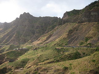
Tarrafal de São Nicolau is a city in the western part of the island of São Nicolau, Cape Verde. With a population of 3,733, it is the most populous settlement of the island. It is the seat of the Tarrafal de São Nicolau Municipality, and the main port of the island. It is situated on the west coast, 9 km southwest of Ribeira Brava.

Trás os Montes is a settlement in the northern part of the island of Santiago, Cape Verde. In 2010 its population was 464. It is situated 4 km northeast of Tarrafal.
Figueira das Naus is a settlement in the western part of the island of Santiago, Cape Verde. It is part of the municipality of Santa Catarina. In 2010 its population was 1,157. It is situated 11 km south of Tarrafal and 12 km northwest of Assomada. It is situated on the secondary road connecting Fundura and Ribeira da Prata.
Chão Bom is a settlement in the northern part of the island of Santiago, Cape Verde. It is situated near the west coast, 3 km southeast of Tarrafal on the main road (EN1-ST01) south to Assomada and Praia. In 2010 its population was 5,166. The Tarrafal prison camp was situated north of Chão Bom. The stadium Estádio de Mangue is in the northwestern part in the communal limits. Silvino Lopes Évora, a writer, poet, journalist and a university professor is native to Chão Bom.
Tarrafal de Monte Trigo is a settlement in the southwestern part of the island of Santo Antão, Cape Verde. In 2010 its population was 841. It is situated on the coast, 27 km west of the island capital Porto Novo. The settlement was mentioned as Terrafal in the 1747 map by Jacques-Nicolas Bellin.
Hortelã is a settlement in the western part of the island of São Nicolau, Cape Verde. In 2010 its population was 181. It is situated at the southern foot of Monte Gordo, 5 km north of Tarrafal de São Nicolau and 6 km west of Ribeira Brava.
Ribeira Prata is a settlement in the northwestern part of the island of São Nicolau, Cape Verde. In 2010 its population was 343. It is situated near the north coast, 3 km northeast of Praia Branca and 11 km north of Tarrafal de São Nicolau.
Palhal is a settlement in the western part of the island of São Nicolau, Cape Verde. In 2010 its population was 100. It is situated 2 km west of Cabeçalinho and 5 km northeast of Tarrafal de São Nicolau.
Ribeira dos Calhaus is a settlement in the western part of the island of São Nicolau, Cape Verde. It is part of the municipality of Tarrafal de São Nicolau. It is situated in a valley northwest of Monte Gordo, 3 km southeast of Praia Branca and 7 km north of Tarrafal de São Nicolau.
Serra Malagueta is a settlement in the northwestcentral part of the island of Santiago, Cape Verde. It is part of the municipality of Santa Catarina. It is situated on the main road between Assomada and Tarrafal (EN1-ST01), 1 km south of Curral Velho, 3 km (1.9 mi) north of Fundura and 11 km (6.8 mi) north of Assomada. In 2010 its population was 572. The main village, Locotano, sits at about 800 m elevation, northwest of the summit of Serra Malagueta, and lies partly in the Serra Malagueta Natural Park.
Veneza is a settlement in the northeastern part of the island of Santiago, Cape Verde. It is part of the municipality of São Miguel. It is a suburb of the city of Calheta de São Miguel, north of the city centre. It is situated on the coast, along the Praia-Pedra Badejo-Tarrafal Road (EN1-ST02). In 2010 its population was 1,375.
Figueira Muita is a settlement in the northern part of the island of Santiago, Cape Verde. It is part of the municipality of Tarrafal. In 2010 its population was 160. It is located about 2 km south of Ribeira da Prata and 8 km south of Tarrafal.
Mancholy is a settlement in the northwestern part of the island of Santiago, Cape Verde. It is part of the municipality of Santa Catarina. In 2010 its population was 903. It is situated 4 km northwest of Assomada, on the road to Tarrafal (EN1-ST01).
Milho Branco is a settlement in the northern part of the island of Santiago, Cape Verde. It is part of the municipality of Tarrafal. In 2010 its population was 165. It is located about 5 km southeast of Tarrafal.
Santa Cruz is a settlement in the eastern part of the island of Santiago, Cape Verde. It is part of the municipality of Santa Cruz. It is located 2 km south of Cancelo and 3 km west of Pedra Badejo, on the national road to Tarrafal (EN1-ST02). In 2010 its population was 2,019.
Ribeirão Chiqueiro is a village in the southcentral part of the island of Santiago, Cape Verde. It is part of the municipality of São Domingos. It is 5 km southeast of the municipal seat São Domingos. In 2010 its population was 775. Its elevation is around 270 m. The national road EN1-ST01 passes near the village.
Curral Velho is a settlement in the northern part of the island of Santiago, Cape Verde. It is part of the municipality of Tarrafal. In 2010 its population was 358. It is located 1 km north of Locotano and 11 km southeast of Tarrafal, on the Praia-Assomada-Tarrafal Road (EN1-ST01).


