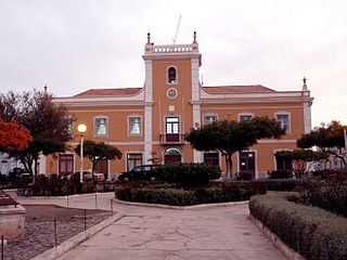
Calheta de São Miguel is a city in the northern part of the island of Santiago, Cape Verde. In 2010 its population was 3,175. It is situated on the east coast, 31 km north of the capital Praia. It is the seat of São Miguel municipality.

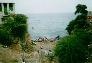
São Pedro is a village in the southwestern part of the island of Sao Vicente, Cape Verde. It is situated on the south coast, approximately 10 km southwest of the island capital Mindelo. In 2010 its population was 991. Cesária Évora Airport, the island's international airport is directly north of São Pedro. It was mentioned as a small port as "P. St. Pedro" in the 1747 map by Jacques-Nicolas Bellin. The lighthouse Farol de D. Amélia sits on the Ponta Machado, 3 km west of the village.

Figueira Pavão is a settlement in the southeastern part of the island of Fogo, Cape Verde. In 2010 its population was 320. It is situated 3 km southwest of Cova Figueira and 20 km east of the island capital São Filipe. Nearby settlements are Achada Furna to the west and Estância Roque to the north.
Achada Monte is a town in the northern part of the island of Santiago, Cape Verde and is part of the municipality of São Miguel. It is situated near the east coast, 8 km northwest of Calheta de São Miguel. In 2010 its population was 1,652. It is on the road connecting Praia and Tarrafal through Pedra Badejo, the EN1-ST02. The small bay Mangue de Sete Ribeiras is located east of the settlement. Ribeira Principal flows west of the village.
Carvoeiros is a settlement in the northern part of the island of São Nicolau, Cape Verde. It is situated on the north coast, 2 km east of Queimadas and 4 km north of Ribeira Brava.
Estância de Brás is a settlement in the northern part of the island of São Nicolau, Cape Verde. It is situated near the north coast, 2 km north of Fajã de Baixo and 6 km northwest of Ribeira Brava.
Hortelã is a settlement in the western part of the island of São Nicolau, Cape Verde. In 2010 its population was 181. It is situated at the southern foot of Monte Gordo, 5 km north of Tarrafal de São Nicolau and 6 km west of Ribeira Brava.
Juncalinho is a town in the eastern part of the island of São Nicolau, Cape Verde. It is situated on the north coast, 17 km east of Ribeira Brava. The local football club is FC Belo Horizonte.
Morro Brás is a settlement in the eastern part of the island of São Nicolau, Cape Verde. It is situated on the north coast, 11 km east of Ribeira Brava.

Ribeira da Vinha is a village in the central part of the island of Sao Vicente, Cape Verde. It is situated in the plain southwest of the island capital Mindelo, approximately 3 km from the city centre.

São Jorge is a settlement in the central part of the island of Santiago, Cape Verde. It is part of the São Lourenço dos Órgãos municipality. In 2010 its population was 6. It is situated 2.5 km southwest of João Teves and 4 km southeast of Picos. Its elevation is 319 meters.
São Francisco is a subdivision of the city of Praia in the island of Santiago, Cape Verde. Its population was 570 at the 2010 census. It is situated 7 km north of the city centre. 3.5 km to its east is the São Francisco Bay, and 2.5 km to its northeast the village Vale da Custa, part of the municipality of São Domingos.
Ribeira Prata is a settlement in the northwestern part of the island of São Nicolau, Cape Verde. In 2010 its population was 343. It is situated near the north coast, 3 km northeast of Praia Branca and 11 km north of Tarrafal de São Nicolau.
Ribeira Julião is a village in the central part of the island of Sao Vicente, Cape Verde. In 2010 its population was 611. It is situated in the valley of the stream Ribeira de Julião, south of the island capital Mindelo, 3.5 km from the city centre. An adjacent neighbourhood of Mindelo is named Ribeira de Julião.
Milho Branco is a village in the southeastern part of the island of Santiago, Cape Verde. It is situated 2 km north of Ribeirão Chiqueiro, 5 km east of the city São Domingos and 12 km north of the capital Praia. The national road EN1-ST02 from Ribeirão Chiqueiro to Tarrafal via Pedra Badejo passes through the village. It is part of the municipality of São Domingos. In 2010 its population was 607.
Fragata is a settlement in the northwestern part of the island of São Nicolau, Cape Verde. In 2010 its population was 172. It is situated 2 km south of Ribeira Prata and 9 km north of Tarrafal de São Nicolau. It consists of the localities Cruzinha, Geronimo, Santa Barbara and Fragatona (Tope).
Ribeira dos Calhaus is a settlement in the western part of the island of São Nicolau, Cape Verde. It is part of the municipality of Tarrafal de São Nicolau. It is situated in a valley northwest of Monte Gordo, 3 km southeast of Praia Branca and 7 km north of Tarrafal de São Nicolau.

Tinteira is a settlement in the eastern part of the island of Fogo, Cape Verde. It is situated 4 km north of Cova Figueira, 5 km south of Relva and 22 km east of the island capital São Filipe. At the 2010 census its population was 410. Its elevation is 300 meters. Tinteira consists of the localities Tinteira, Cova Matinho and Cutelo Capado.
São Martinho Grande is a settlement in the southern part of the island of Santiago, Cape Verde. It is part of the municipality Ribeira Grande de Santiago. It is located 4 km east from Cidade Velha and 6.5 km west of Praia city centre. The national road EN1-ST05 passes north of the village. 1.5 km south of the village is a small bay of the Atlantic Ocean, Calheta de São Martinho. It was mentioned as "Kalyete de S. Martin" on the 1747 map by Jacques-Nicolas Bellin.
Mato Correia is a village in the northeastern part of the island of Santiago, Cape Verde. It is part of the municipality of São Miguel. It is located southwest of Espinho Branco, 1.5 km north of Pilão Cão and 5 km northwest of São Miguel. In 2010 its population was 328.