
Ribeira Grande de Santiago is a concelho (municipality) of Cape Verde. It is situated in the southwestern part of the island of Santiago. Its seat is the city Cidade Velha. Its population was 8,325 at the 2010 census, and its area is 137.3 km².

São Lourenço dos Órgãos is a concelho (municipality) of Cape Verde. It is situated in the mountainous central part of the island of Santiago. Its seat is the city João Teves. Its population was 7,388 at the 2010 census, and its area is 36.9 km2. The municipality is bordered by Santa Cruz to the northeast, São Domingos to the south, Ribeira Grande de Santiago to the southwest and São Salvador do Mundo to the northwest. Pico de Antónia, the island's highest mountain, straddles the borders of São Lourenço dos Órgãos, São Salvador do Mundo and Ribeira Grande de Santiago.

São Salvador do Mundo is a concelho (municipality) of Cape Verde. It is situated in the central part of the island of Santiago. Its seat is the city Picos. Its population was 8,677 at the 2010 census, and its area is 26.5 km2, making it the smallest municipality of Cape Verde. The municipality borders Santa Cruz to the northeast, São Lourenço dos Órgãos to the southeast, Ribeira Grande de Santiago to the southwest and Santa Catarina to the northwest.

Porto Mosquito is a settlement in the southern part of the island of Santiago, Cape Verde. It is situated on the south coast, 10 km northwest of Cidade Velha. It is part of the municipality of Ribeira Grande de Santiago.
Porto Gouveia is a settlement in the southern part of the island of Santiago, Cape Verde. It is situated on the south coast, 7 km northwest of Cidade Velha. It is part of the municipality of Ribeira Grande de Santiago.
Santana is a settlement in the southern part of the island of Santiago, Cape Verde. It is part of the municipality of Ribeira Grande de Santiago. It is situated 2 km east of Belém and 9 km northwest of Cidade Velha.
João Varela is a settlement in the southern part of the island of Santiago, Cape Verde. It is situated 5 km northeast of Cidade Velha and 9 km northwest of the capital Praia. It is part of the municipality of Ribeira Grande de Santiago.
Coculi is a town in the northern part of the island of Santo Antão, Cape Verde. It is situated on the river Ribeira Grande, 4 km southwest of the town Ribeira Grande and 17 km north of the island capital Porto Novo. About 400 meters to its west is the confluence of Ribeira de Chã das Pedras.
Santíssimo Nome de Jesus is a freguesia of Cape Verde. It covers the eastern part of the municipality of Ribeira Grande de Santiago, on the island of Santiago.

Pombas is a city in the northeastern part of the island of Santo Antão, Cape Verde. It is the seat of the municipality Paul. It is situated on the coast, at the mouth of the Ribeira do Paul, 7 km (4.3 mi) southeast of Ribeira Grande and 15 km (9.3 mi) north of the island capital Porto Novo. The national roads EN1-SA02 and EN1-SA03 connect Pombas with Ribeira Grande and Porto Novo, respectively. Pombas was elevated from town to city in 2010.
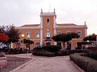
Praia is a concelho (municipality) of Cape Verde. It is situated in the southern part of the island of Santiago. Its seat is the city Praia, the capital of Cape Verde. Its area is 120.6 km2 (46.6 sq mi), and its population was 131,719 at the 2010 census. The municipality consists of one freguesia, Nossa Senhora da Graça. The city hall is located in the Platô part of the city.
Salineiro is a village in the southern part of the island of Santiago, Cape Verde. It is part of the municipality of Ribeira Grande de Santiago. In 2010 its population was 1,113. It is located on the western edge of the Ribeira Grande gorge, 2.5 km north of Cidade Velha and 11 km west of the capital Praia.
Chã de Pedras is a settlement in the northcentral part of the island of Santo Antão, Cape Verde. In 2010 its population was 1,266. It is situated about 5 km south of Coculi, 8 km southeast of the city Ribeira Grande and 12 km northwest of the island capital Porto Novo. It consists of 21 localities in the valley of the Ribeira de Chã de Pedras, a right tributary of the Ribeira Grande. The elevation of the largest village, Pia de Cima, is about 430 metres.

Nossa Senhora do Rosario church is a 15th century church in the town of Cidade Velha on the island of Santiago, Cape Verde. It is located in the northwest of the town, near the right (west) bank of the stream Ribeira Grande de Santiago. The historic centre of Cidade Velha is an UNESCO World Heritage site since June 2009.
São Martinho Grande is a settlement in the southern part of the island of Santiago, Cape Verde. It is part of the municipality Ribeira Grande de Santiago. It is located 4 km east from Cidade Velha and 6.5 km west of Praia city centre. The national road EN1-ST05 passes north of the village. 1.5 km south of the village is a small bay of the Atlantic Ocean, Calheta de São Martinho. It was mentioned as "Kalyete de S. Martin" on the 1747 map by Jacques-Nicolas Bellin.
Belém is a settlement in the southwest of the island of Santiago, Cape Verde. It is part of the municipality of Ribeira Grande de Santiago. It is 2 km west of Santana, 6 km north of Porto Gouveia and 11 km northwest of the municipal seat Cidade Velha. In 2010 its population was 382.


