
Tarrafal is a concelho (municipality) of Cape Verde. It is situated in the northern part of the island of Santiago. Its seat is the town Tarrafal. Its population was 18,565 at the 2010 census, and its area is 120.8 km2.

Calheta de São Miguel is a city in the northern part of the island of Santiago, Cape Verde. In 2010 its population was 3,175. It is situated on the east coast, 31 km north of the capital Praia. It is the seat of São Miguel municipality.

Mosteiros is a concelho (municipality) of Cape Verde. Situated in the northeastern part of the island of Fogo, it covers 19% of the island area, and is home to 26% of its population. Its seat is the city Mosteiros (Igreja). Its population was 9,524 at the 2010 census, and its area is 89.45 km2.

São Lourenço dos Órgãos is a concelho (municipality) of Cape Verde. It is situated in the mountainous central part of the island of Santiago. Its seat is the city João Teves. Its population was 7,388 at the 2010 census, and its area is 36.9 km2. The municipality is bordered by Santa Cruz to the northeast, São Domingos to the south, Ribeira Grande de Santiago to the southwest and São Salvador do Mundo to the northwest. Pico de Antónia, the island's highest mountain, straddles the borders of São Lourenço dos Órgãos, São Salvador do Mundo and Ribeira Grande de Santiago.
Santa Catarina do Fogo is a concelho (municipality) of Cape Verde. Situated in the southeastern part of the island of Fogo, it covers 32% of the island area, and is home to 14% of its population. Its seat is the city Cova Figueira. The Municipality of Santa Catarina do Fogo was created in 2005; before 2005, it was a parish of the Municipality of São Filipe.

São Salvador do Mundo is a concelho (municipality) of Cape Verde. It is situated in the central part of the island of Santiago. Its seat is the city Picos. Its population was 8,677 at the 2010 census, and its area is 26.5 km2, making it the smallest municipality of Cape Verde. The municipality borders Santa Cruz to the northeast, São Lourenço dos Órgãos to the southeast, Ribeira Grande de Santiago to the southwest and Santa Catarina to the northwest.

Tarrafal de São Nicolau is a concelho (municipality) of Cape Verde. Situated in the western part of the island of São Nicolau, it covers 35% of the island area (119.8 km²), and is home to 41% of its population. Its seat is the town Tarrafal de São Nicolau.

Ribeira Brava is a concelho (municipality) of Cape Verde. Situated in the eastern part of the island of São Nicolau, it covers 65% of the island area, and is home to 59% of its population. Its seat is the city Ribeira Brava.

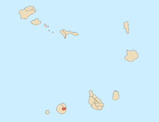
The territory of Cape Verde is divided into 22 concelhos (municipalities), and subdivided into 32 freguesias.

Ribeira da Prata is a town in the northern part of the island of Santiago, Cape Verde belonging to the municipality of Tarrafal. In 2010 its population was 1,009. It was mentioned as Rivera de Prata in the 1747 map by Jacques-Nicolas Bellin.
Achada Monte is a town in the northern part of the island of Santiago, Cape Verde and is part of the municipality of São Miguel. It is situated near the east coast, 8 km northwest of Calheta de São Miguel. In 2010 its population was 1,652. It is on the road connecting Praia and Tarrafal through Pedra Badejo, the EN1-ST02. The small bay Mangue de Sete Ribeiras is located east of the settlement. Ribeira Principal flows west of the village.
Figueira das Naus is a settlement in the western part of the island of Santiago, Cape Verde. It is part of the municipality of Santa Catarina. In 2010 its population was 1,157. It is situated 11 km south of Tarrafal and 12 km northwest of Assomada. It is situated on the secondary road connecting Fundura and Ribeira da Prata.

Pombas is a city in the northeastern part of the island of Santo Antão, Cape Verde. It is the seat of the municipality Paul. It is situated on the coast, at the mouth of the Ribeira do Paul, 7 km (4.3 mi) southeast of Ribeira Grande and 15 km (9.3 mi) north of the island capital Porto Novo. The national roads EN1-SA02 and EN1-SA03 connect Pombas with Ribeira Grande and Porto Novo, respectively. Pombas was elevated from town to city in 2010.

São Jorge is a settlement in the central part of the island of Santiago, Cape Verde. It is part of the São Lourenço dos Órgãos municipality. In 2010 its population was 6. It is situated 2.5 km southwest of João Teves and 4 km southeast of Picos. Its elevation is 319 meters.
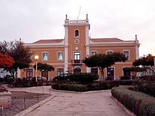
Praia is a concelho (municipality) of Cape Verde. It is situated in the southern part of the island of Santiago. Its seat is the city Praia, the capital of Cape Verde. Its area is 120.6 km2 (46.6 sq mi), and its population was 131,719 at the 2010 census. The municipality consists of one freguesia, Nossa Senhora da Graça. The city hall is located in the Platô part of the city.

Ribeira Grande is the largest town of the Ribeira Grande Municipality on the island of Santo Antão, Cape Verde. It has become a city in 2010. In 2010 its population was 2,564. It is situated in the northeastern part of the island, near the outflow of the river Ribeira Grande and its tributary Ribeira da Torre into the Atlantic Ocean. Neighborhoods include Tarrafal, Rua de Agua, Rua d'Horta and Penha de França.

Tarrafal is a city in the northern part of the island of Santiago, Cape Verde. In 2010 its population was 6,656. It is a fishing port situated on the northwestern coast. It constitutes the seat of the Tarrafal Municipality.
The following is a timeline of the city of Praia, capital of Cape Verde.
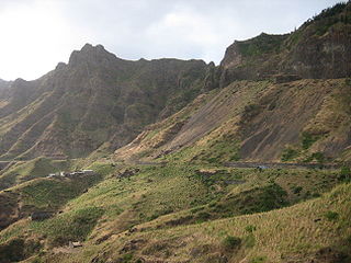
Serra Malagueta is a settlement in the northwestcentral part of the island of Santiago, Cape Verde. It is part of the municipality of Santa Catarina. It is situated on the main road between Assomada and Tarrafal (EN1-ST01), 1 km south of Curral Velho, 3 km (1.9 mi) north of Fundura and 11 km (6.8 mi) north of Assomada. In 2010 its population was 572. The main village, Locotano, sits at about 800 m elevation, northwest of the summit of Serra Malagueta, and lies partly in the Serra Malagueta Natural Park.
Ponta Verde is a seaside settlement in the northeastern part of the island of Santiago, Cape Verde. It is a suburb of the city of Calheta de São Miguel, part of the municipality of São Miguel. It is situated on the Praia-Pedra Badejo-Tarrafal Road (EN1-ST02), 1.5 km northwest of the centre of Calheta de São Miguel. In 2010 its population was 1,065.


