
Sal is an island in Cape Verde. Sal is a tourist destination with white sandy beaches and over 350 days of sunshine a year. It is one of the three sandy eastern islands of the Cape Verde archipelago in the central Atlantic Ocean, 350 mi (560 km) off the west coast of Africa. Cabo Verde is known for year-round kiteboarding, for the large reserve of Caretta turtles which hatch from July to September, and the music of Cesaria Evora.
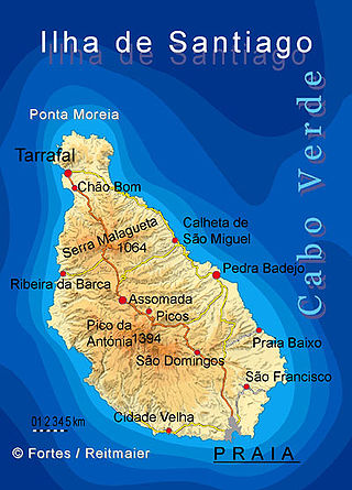
Santiago is the largest island of Cape Verde, its most important agricultural centre and home to half the nation's population. Part of the Sotavento Islands, it lies between the islands of Maio and Fogo. It was the first of the islands to be settled: the town of Ribeira Grande was founded in 1462. Santiago is home to the nation's capital city of Praia.

Santa Catarina is a concelho (municipality) of Cape Verde. It is situated in the western part of the island of Santiago. Its seat is the city of Assomada. Its population was 45,920 in 2017 (estimate). Its area is 242.6 km2 (93.7 sq mi).
Santa Cruz is a concelho (municipality) of Cape Verde. It is situated in the eastern part of the island of Santiago. Its seat is the city Pedra Badejo. Its population was 26,617 at the 2010 census, and its area is 112.2 km2.

São Lourenço dos Órgãos is a concelho (municipality) of Cape Verde. It is situated in the mountainous central part of the island of Santiago. Its seat is the city João Teves. Its population was 7,388 at the 2010 census, and its area is 36.9 km2. The municipality is bordered by Santa Cruz to the northeast, São Domingos to the south, Ribeira Grande de Santiago to the southwest and São Salvador do Mundo to the northwest. Pico de Antónia, the island's highest mountain, straddles the borders of São Lourenço dos Órgãos, São Salvador do Mundo and Ribeira Grande de Santiago.

São Salvador do Mundo is a concelho (municipality) of Cape Verde. It is situated in the central part of the island of Santiago. Its seat is the city Picos. Its population was 8,677 at the 2010 census, and its area is 26.5 km2, making it the smallest municipality of Cape Verde. The municipality borders Santa Cruz to the northeast, São Lourenço dos Órgãos to the southeast, Ribeira Grande de Santiago to the southwest and Santa Catarina to the northwest.

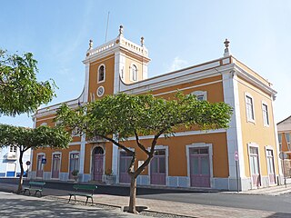
Assomada is a city on the Sotavento (leeward) island of Santiago in Cape Verde. Since 1912, it is the seat of the municipality of Santa Catarina, which comprises the central western part and much of the interior of the island. It is the largest city in that region.

Santa Maria is a city in the southern part of the island municipality of Sal, Cape Verde. It is located on the south coast, about 16 km south of the Amílcar Cabral International Airport, and 20 km south of the island capital Espargos.
Pedra Badejo is a city in the eastern part of the island of Santiago, Cape Verde. It is on the east coast, 25 km (16 mi) north of the island capital Praia, 8 km (5.0 mi) southeast of Calheta de São Miguel and 15 km (9.3 mi) east of Assomada. It is the seat of Santa Cruz municipality. At the 2010 census, the town had 9,859 inhabitants.
The Santiago Island League (North) is a regional championship played in Santiago Island, Cape Verde. The competition is organized by the Santiago North Regional Football Association (Associação Regional de Futebol de Santiago Sul, ARFSS). The winner of the championship plays in Cape Verdean football Championships of each season.
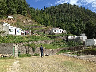
Fazenda is a settlement in the northern part of the island of Santiago, Cape Verde. It is situated 4 km north of Tarrafal.
Cancelo is a settlement in the eastern part of the island of Santiago, Cape Verde. It is part of the municipality Santa Cruz. It is situated near the east coast, 4 km northwest of Pedra Badejo and 5 km southeast of Calheta de São Miguel. In 2010 its population was 2,042.
Praia is a concelho (municipality) of Cape Verde. It is situated in the southern part of the island of Santiago. Its seat is the city Praia, the capital of Cape Verde. Its area is 120.6 km2 (46.6 sq mi), and its population was 131,719 at the 2010 census. The municipality consists of one freguesia, Nossa Senhora da Graça. The city hall is located in the Platô part of the city.

Santa Cruz da Baixa Verde is a city in the state of Pernambuco, Brazil. The population in 2020, according with IBGE was 12,650 inhabitants and the total area is 114.93 km².
Record Cabo Verde is a channel of Record in Cape Verde. It is the first Brazilian based channel to have its own version in Cape Verde. The network was launched on 31 March 2007.
Pico da Cruz is a settlement in the northeastern part of the island of Santo Antão, Cape Verde. In 2010 its population was 138. It is situated 6 km southwest of Pombas and 10 km northeast of the island capital Porto Novo. Its elevation is about 1,400 meters. The village is named after the nearby mountain Pico da Cruz. It lies in the Cova-Paul-Ribeira da Torre Natural Park.

The following is a timeline of the city of Praia, capital of Cape Verde.
The following lists events that happened during 2005 in Cape Verde.

Ribeira Seca is the largest stream of the island of Santiago in Cape Verde. It is 18 km (11 mi) long and its basin area is 71.5 km2 (27.6 sq mi). Located in the eastern part of the island, it flows through the municipalities of São Lourenço dos Órgãos and Santa Cruz. Its source is near the highest point of the island, Pico de Antónia, from where it flows to the east to João Teves. It turns to the northeast and flows into the Atlantic Ocean at Achada Fazenda, 2 km southeast of Pedra Badejo. It is called Ribeira de Pico da Antónia in its uppermost part, and Ribeira de Lage near João Teves.
Achada Ponta is a settlement in the eastern part of the island of Santiago, Cape Verde. It is part of the municipality Santa Cruz. It is located near the east coast, 2 km southeast of Achada Fazenda and 5 kilometers southeast of Pedra Badejo. In 2010 its population was 403.
