Tarrafal is a concelho (municipality) of Cape Verde. It is situated in the northern part of the island of Santiago. Its seat is the town Tarrafal. Its population was 18,565 at the 2010 census, and its area is 120.8 km2.

São Salvador do Mundo is a concelho (municipality) of Cape Verde. It is situated in the central part of the island of Santiago. Its seat is the city Picos. Its population was 8,677 at the 2010 census, and its area is 26.5 km2, making it the smallest municipality of Cape Verde. The municipality borders Santa Cruz to the northeast, São Lourenço dos Órgãos to the southeast, Ribeira Grande de Santiago to the southwest and Santa Catarina to the northwest.
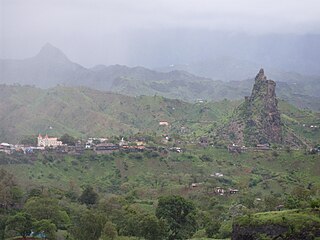
Picos, also known as Achada Igreja, is a city in the central part of the island of Santiago, Cape Verde. It is the seat of São Salvador do Mundo municipality. Picos is located 4 km southeast of Assomada and 23 km northwest of the capital city of Praia, near the national road from Praia to Tarrafal via Assomada (EN1-ST01).

Achada Furna is a settlement in the southern part of the island of Fogo, Cape Verde. It is situated 15 km east of the island capital São Filipe. At the 2010 census its population was 495. Its elevation is about 870 meters. Nearby places include Cabeça Fundão to the north, Figueira Pavão to the east, Fonte Aleixo to the south and Monte Largo to the west.

Achada Grande is a settlement in the northeastern part of the island of Fogo, Cape Verde. It is situated near the coast, 6 km southeast of Mosteiros. Its population was 538 in 2010. Nearby settlements include Corvo to the north and Relva to the southeast.
Figueira Pavão is a settlement in the southeastern part of the island of Fogo, Cape Verde. In 2010 its population was 320. It is situated 3 km southwest of Cova Figueira and 20 km east of the island capital São Filipe. Nearby settlements are Achada Furna to the west and Estância Roque to the north.

Fonte Aleixo is a settlement in the southern part of the island of Fogo, Cape Verde. It is situated 3 km south of Achada Furna and 16 km southeast of the island capital São Filipe. In 2010 its population was 401.
Achada Fazenda is a settlement in the eastern part of the island of Santiago, Cape Verde. In 2010 its population was 2,592. It is situated near the east coast, 2 km southeast of Pedra Badejo, near the estuary of the Ribeira Seca.
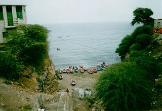
Achada Tenda is a town in the northern part of the island of Santiago, Cape Verde. In 2010 its population was 1,242. It is situated on the east coast, 10 km southeast of Tarrafal. The small bay Porto Formoso is situated near the town.
Fazenda is a settlement in the northern part of the island of Santiago, Cape Verde. It is situated 4 km north of Tarrafal.
Nossa Senhora da Luz is a freguesia of Cape Verde. It covers the eastern part of the municipality of São Domingos, on the island of Santiago.

São Nicolau Tolentino is a freguesia of Cape Verde. It covers the western part of the municipality of São Domingos, on the island of Santiago.
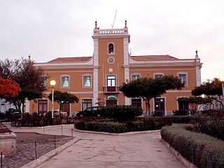
Praia is a concelho (municipality) of Cape Verde. It is situated in the southern part of the island of Santiago. Its seat is the city Praia, the capital of Cape Verde. Its area is 120.6 km2 (46.6 sq mi), and its population was 131,719 at the 2010 census. The municipality consists of one freguesia, Nossa Senhora da Graça. The city hall is located in the Platô part of the city.
Praia Baixo is a village in the southeastern part of the island of Santiago, Cape Verde. It is part of the municipality of São Domingos and the parish of Nossa Senhora da Luz. It is situated on the east coast, 1.5 km northwest of Achada Baleia, 11 km southeast of Pedra Badejo, 10 km east of São Domingos and 16 km north of the capital Praia. In 2010 its population was 952.

Ribeira da Trindade is a stream in the southern part of the island of Santiago in Cape Verde. It is the most important river of Praia, the capital of Cape Verde. Its basin area is 24.9 km2 (9.6 sq mi). The stream flows northwest to southeast and is about 15 km in length. Its source is in the municipality of São Domingos, near the settlement Achada Mitra. It flows through the city of Praia and discharges into the Praia Harbour, near the city centre.

Monte Largo is a settlement in the southern part of the island of Fogo, Cape Verde. It is situated 1.5 km northeast of Salto, 3 km southeast of Monte Grande, 3 km west of Achada Furna and 13 kilometres (8.1 mi) east of the island capital São Filipe. At the 2010 census its population was 274. Its elevation is about 800 meters.
Achada Longueira is a settlement in the northern part of the island of Santiago, Cape Verde. It is part of the municipality of Tarrafal. In 2010, its population was 520. It is located about 7 kilometres (4.3 mi) southeast of Tarrafal, on the Praia-Assomada-Tarrafal Road (EN1-ST01).
Achada Baleia is a settlement in the eastern part of the island of Santiago, Cape Verde. It is part of the municipality of São Domingos. In 2010 its population was 376. It is situated near the east coast, 1.5 km southeast of Praia Baixo, 2 km northwest of Baía and 15 km northeast of Praia. It sits at an elevation of about 50 meters.
Baía is a settlement in the eastern part of the island of Santiago, Cape Verde. It is part of the municipality of São Domingos. In 2010 its population was 489. It is situated near the east coast, 2 km southeast of Achada Baleia, 2 km northwest of Moia Moia and 14 km northeast of Praia. It sits at an elevation of about 20 meters. The settlement consists of several localities, including Achada Baixo, Castelinho and Covão Santana. The ruined Gothic church of Nossa Senhora da Luz, which was part of the 15th century Portuguese settlement Alcatrazes, stands at the shore near Baía.
Achada Leite is a settlement on the west coast of the island of Santiago, Cape Verde. It is part of the municipality of Santa Catarina. It lies 2.5 km south of Ribeira da Barca and 11 km west of the municipal seat Assomada. In 2010 its population was 142.