
Cape Verde is a group of arid Atlantic islands which are home to distinct communities of plants, birds, and reptiles. The islands constitute the unique Cape Verde Islands dry forests ecoregion, according to the World Wildlife Fund.

The Cape Verde warbler is an Old World warbler in the genus Acrocephalus. It is also known as the Cape Verde cane warbler or Cape Verde swamp warbler, and in Creole as tchota-de-cana, chincherote,. It breeds on Santiago, Fogo, and São Nicolau in the Cape Verde Islands. It previously bred on Brava. This species is found in well-vegetated valleys, avoiding drier areas. It nests in reedbeds, two to three eggs being laid in a suspended nest.

Boa Vista, also written as Boavista, is a desert-like island that belongs to the Cape Verde Islands. At 631.1 km2 (243.7 sq mi), it is the third largest island of the Cape Verde archipelago.

Santiago is the largest island of Cape Verde, its most important agricultural centre and home to half the nation's population. Part of the Sotavento Islands, it lies between the islands of Maio and Fogo. It was the first of the islands to be settled: the town of Ribeira Grande was founded in 1462. Santiago is home to the nation's capital city of Praia.

The Cape Verde Islands dry forests is a tropical and subtropical dry broadleaf forests ecoregion in the Cape Verde Islands, which constitute the country of Cabo Verde. The islands lie off the western coast of Africa.

Santa Catarina is a concelho (municipality) of Cape Verde. It is situated in the western part of the island of Santiago. Its seat is the city of Assomada. Its population was 45,920 in 2017 (estimate). Its area is 242.6 km2 (93.7 sq mi).

Monte Gordo is a mountain on the island of São Nicolau, Cape Verde. At 1,312 m elevation, it is the island's highest point. It is situated in the western part of the island, 6 km west of the island capital Ribeira Brava. The mountain is of volcanic origin, less than 1 million years old. The boundary of the municipalities Tarrafal de São Nicolau and Ribeira Brava runs over the mountain. It is part of the Monte Gordo Natural Park.

Pico de Antónia is a mountain located in the central part of the island of Santiago in Cape Verde. At 1,392 m (4,567 ft), it is the highest point of the island. The mountain is part of the protected area Parque Natural da Serra do Pico de Antónia. The towns Picos and Assomada lie close to the mountain. The Serra do Pico da Antónia has been identified by BirdLife International as an Important Bird Area.

Rabil is a town on the island of Boa Vista, Cape Verde. It was the island's former capital. Rabil is the island's second largest town, located 6 kilometres (3.7 mi) southeast of the island capital of Sal Rei. Its population was 1,248 in 2010. The island's airport, Aristides Pereira International Airport, is situated northwest of the town.

Curral Velho is a deserted village in the southern part of the island of Boa Vista, Cape Verde. The village is situated on the south coast, around 25 km southeast of the island capital of Sal Rei. The area around Curral Velho is a protected landscape, covering 16.35 square kilometres (6.31 sq mi). The nearby islet Ilhéu de Curral Velho and the adjacent coast are an important area for birds. The old houses of Curral Velho, São Domingos and Prazeres, examples of traditional Capeverdean architecture, are in a precarious state of conservation.

The wildlife of Cape Verde is spread over its archipelago of ten islands and three islets, which all have parks under their jurisdiction by decree promulgated by the Cape Verde government. Located off the west coast of Africa, the total land area of the island nation is 4,564 square kilometres (1,762 sq mi). The wildlife consists of many tropical dry forest and shrub land, endemic flora and fauna, and rare breeding seabirds and plants, which are unique to this group of islands.

Tourism in Cape Verde, a group of islands off the coast of Senegal, West Africa, started in the 1970s on the island of Sal and increased slowly in the 1980s and 1990s.

Cape Verde or Cabo Verde, officially the Republic of Cabo Verde, is an archipelago and island country in the central Atlantic Ocean, consisting of ten volcanic islands with a combined land area of about 4,033 square kilometres (1,557 sq mi). These islands lie between 600 to 850 kilometres west of Cap-Vert situated at the westernmost point of continental Africa. The Cape Verde islands form part of the Macaronesia ecoregion, along with the Azores, the Canary Islands, Madeira, and the Savage Isles.
Bourne's heron, also known as the Cape Verde heron, Cape Verde purple heron or Santiago heron, or locally in Portuguese as the garça vermelha, is an endangered subspecies of the purple heron that is endemic to the Cape Verde archipelago, in the Atlantic Ocean off the coast of West Africa. It is sometimes considered a full species, Ardea bournei.
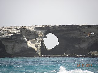
The Ilhéu de Curral Velho and adjacent coast Important Bird Area lies in the southeastern part of the island of Boa Vista in the Cape Verde archipelago off the coast of north-west Africa in the Atlantic Ocean. It is a 986 ha site consisting of the Ilhéu de Curral Velho, as well as the area opposite it on Boa Vista centred on the deserted village of Curral Velho. It was designated as a Ramsar wetland of international importance on July 18, 2005.

Montanha is a settlement in the central part of the island of Santiago, Cape Verde. It is situated 2 km north of João Teves and 8 km southwest of Pedra Badejo. The area is intensively farmed; mainly maize, beans and sugar-cane.
The Lagoas de Pedra Badejo is an area of wetlands on the island of Santiago, Cape Verde. It is a 666-hectare (1,650-acre) site comprising two coastal lagoons at the estuaries of the rivers Ribeira dos Picos and Ribeira Seca, and the entire basin of the latter, including the reservoir Barragem de Poilão. It lies south of the town of Pedra Badejo, on the north-east coast of the island. The lagoons are of great ecological value for birds as they contain fresh or only slightly brackish water. They have been recognised as a wetland of international importance by designation under the Ramsar Convention since 2005.
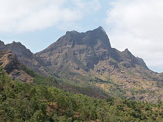
The Serra do Pico de Antónia is a mountain range in the centre of the island of Santiago in the Cape Verde archipelago. It contains the Pico de Antónia, at 1,392 m (4,567 ft) the highest point of the island. It is protected as a natural park, covering 28.73 km2 (11.09 sq mi). The natural park covers the connected mountain ranges of Serra do Pico de Antónia and of Rui Vaz.

Baía do Inferno is a bay on the southwest coast of the island of Santiago in Cape Verde in the Atlantic Ocean. The bay is completely within the municipality of Santa Catarina. It is a large and relatively sheltered bay, characterised by steep cliffs, more than 400 m high in some places. The nearest settlement is Entre Picos de Reda, 3 km inland. Rincão lies 4 km north along the coast, Porto Mosquito 6 km southeast.

