
Val Verde County is a county located on the southern Edwards Plateau in the U.S. state of Texas. The 2014 population is 51,047. Its county seat is Del Rio. In 1936, Val Verde County received Recorded Texas Historic Landmark number 5625 to commemorate its founding.

Camp Verde is a town in Yavapai County, Arizona, United States. As of the 2010 census, the population of the town is 10,873.

Palos Verdes Estates is a city in Los Angeles County, California, United States, situated on the Palos Verdes Peninsula. The city was master-planned by the noted American landscape architect and planner Frederick Law Olmsted Jr. The city is located along the Southern California coastline of the Pacific Ocean.

Rancho Palos Verdes is a city in Los Angeles County, California atop the Palos Verdes Hills and bluffs of the Palos Verdes Peninsula. A suburb of Los Angeles, it is known for expensive homes amidst large tracts of open space with expansive views of the Pacific Ocean. Rancho Palos Verdes is translated as "Ranch of Green Sticks", probably referring to the willows in the northeastern part of Bixby Slough shown on earlier maps.

The Verde River is a major tributary of the Salt River in the U.S. state of Arizona. It is about 170 miles (270 km) long and carries a mean flow of 602 cubic feet per second (17.0 m3/s) at its mouth. It is one of the largest perennial streams in Arizona.
El Bosque is a commune of Chile located in Santiago Province, Santiago Metropolitan Region. The commune spans an area of 14.1 km2 (5 sq mi).
La Granja is a commune of Chile located in Santiago Province, Santiago Metropolitan Region.

Tarrafal is a concelho (municipality) of Cape Verde. It is situated in the northern part of the island of Santiago. Its seat is the town Tarrafal. Its population was 18,565 at the 2010 census, and its area is 120.8 km2.

São Lourenço dos Órgãos is a concelho (municipality) of Cape Verde. It is situated in the mountainous central part of the island of Santiago. Its seat is the city João Teves. Its population was 7,388 at the 2010 census, and its area is 36.9 km2. The municipality is bordered by Santa Cruz to the northeast, São Domingos to the south, Ribeira Grande de Santiago to the southwest and São Salvador do Mundo to the northwest. Pico de Antónia, the island's highest mountain, straddles the borders of São Lourenço dos Órgãos, São Salvador do Mundo and Ribeira Grande de Santiago.

Figueira das Naus is a settlement in the western part of the island of Santiago, Cape Verde. It is part of the municipality of Santa Catarina. In 2010 its population was 1,157. It is situated 11 km south of Tarrafal and 12 km northwest of Assomada. It is situated on the secondary road connecting Fundura and Ribeira da Prata.

Pombas is a city in the northeastern part of the island of Santo Antão, Cape Verde. It is the seat of the municipality Paul. It is situated on the coast, at the mouth of the Ribeira do Paul, 7 km (4.3 mi) southeast of Ribeira Grande and 15 km (9.3 mi) north of the island capital Porto Novo. The national roads EN1-SA02 and EN1-SA03 connect Pombas with Ribeira Grande and Porto Novo, respectively. Pombas was elevated from town to city in 2010.
Morro is a settlement in the west of the island of Maio in Cape Verde. It is located 5 km north of the island capital Porto Inglês and 6 km south of Calheta. As of the 2010 census, its population was 310. The beach north of the village, Praia do Morro, is a 6.66 km2 nature reserve.

Juan Pablo Longueira Montes is a Chilean right-wing politician and industrial civil engineer who served as Minister of Economy, Development and Tourism of Chile from 2011 to 2013. He is a member of the Independent Democratic Union (UDI) and served as a Senator before being appointed by President Sebastián Piñera to serve in the Cabinet. He was previously a deputy from 1990 until 2006.

Longueira / Almograve is a Portuguese parish in the municipality of Odemira. The population in 2011 was 1,356, in an area of 91.69 km². It was created on June 12, 2001, from the parish of São Salvador.

São Jorge is a settlement in the central part of the island of Santiago, Cape Verde. It is part of the São Lourenço dos Órgãos municipality. In 2010 its population was 6. It is situated 2.5 km southwest of João Teves and 4 km southeast of Picos. Its elevation is 319 meters.

São Domingos is a city in the central part of the island of Santiago, Cape Verde. In 2010 its population was 2,818. It is the seat of the São Domingos Municipality. It is situated 13 km southeast of Assomada and 13 km northwest of the capital Praia, along the national road from Praia to Assomada (EN1-ST01). The settlement appeared in the 1747 map by Jacques-Nicolas Bellin as St. Domingo.
Praia Baixo is a village in the southeastern part of the island of Santiago, Cape Verde. It is part of the municipality of São Domingos and the parish of Nossa Senhora da Luz. It is situated on the east coast, 1.5 km northwest of Achada Baleia, 11 km southeast of Pedra Badejo, 10 km east of São Domingos and 16 km north of the capital Praia. In 2010 its population was 952.
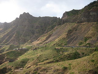
Serra Malagueta is a settlement in the northwestcentral part of the island of Santiago, Cape Verde. It is part of the municipality of Santa Catarina. It is situated on the main road between Assomada and Tarrafal (EN1-ST01), 1 km south of Curral Velho, 3 km (1.9 mi) north of Fundura and 11 km (6.8 mi) north of Assomada. In 2010 its population was 572. The main village, Locotano, sits at about 800 m elevation, northwest of the summit of Serra Malagueta, and lies partly in the Serra Malagueta Natural Park.
Achada Longueira is a settlement in the northern part of the island of Santiago, Cape Verde. It is part of the municipality of Tarrafal. In 2010, its population was 520. It is located about 7 kilometres (4.3 mi) southeast of Tarrafal, on the Praia-Assomada-Tarrafal Road (EN1-ST01).


