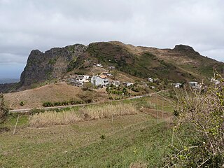
Rui Vaz is a settlement in the central part of the island of Santiago, Cape Verde. In 2010 its population was 1,078. It is situated at 809 m elevation, 2 km south of São Jorge dos Órgãos and 4 km west of São Domingos. It is part of the municipality of São Domingos.

Santana is a settlement in the southern part of the island of Santiago, Cape Verde. It is part of the municipality of Ribeira Grande de Santiago. It is situated 2 km east of Belém and 9 km northwest of Cidade Velha.
Rincão is a settlement in the western part of the island of Santiago, Cape Verde. In 2010 its population was 1,048. It is situated on the west coast, 6 km southwest of Assomada. The westernmost point of the island, Ponta da Janela, lies 2 km to the northwest.
Galinheiro is a settlement in the northwestern part of the island of Fogo, Cape Verde. In 2010 its population was 877. It is situated 2 km northeast of Ponta Verde, 2.5 km southwest of São Jorge and 13 km northeast of the island capital São Filipe.
Campanas Baixo is a settlement in the northern part of the island of Fogo, Cape Verde. It is situated 2 km east of São Jorge, 2 km southwest of Atalaia and 16 km northeast of the island capital São Filipe.
Água de Gato is a settlement in the central part of the island of Santiago, Cape Verde. In 2010 its population was 957. It is situated at about 400 m elevation, 2 km northwest of São Domingos and 2 km east of Rui Vaz.
Cancelo is a settlement in the eastern part of the island of Santiago, Cape Verde. It is part of the municipality Santa Cruz. It is situated near the east coast, 4 km northwest of Pedra Badejo and 5 km southeast of Calheta de São Miguel. In 2010 its population was 2,042.
Eito is a village in the northeastern part of the island of Santo Antão, Cape Verde, part of the municipality of Paul. It is situated 1 km southwest of Pombas, 2 km northeast of Figueiral and 15 km northeast of the island capital Porto Novo. Its population was 979 in 2010.

Cabeça dos Tarrafes is a village in the eastern part of the island of Boa Vista, Cape Verde. The village is located about 2 km south of Fundo das Figueiras and 21 km southeast of the island capital of Sal Rei. It is one of the easternmost communities in Cape Verde.
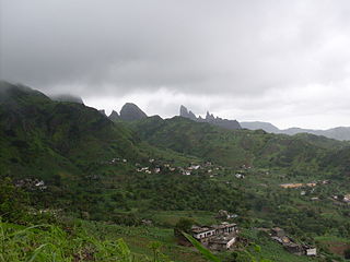
Montanha is a settlement in the central part of the island of Santiago, Cape Verde. It is situated 2 km north of João Teves and 8 km southwest of Pedra Badejo. The area is intensively farmed; mainly maize, beans and sugar-cane.
Fragata is a settlement in the northwestern part of the island of São Nicolau, Cape Verde. In 2010 its population was 172. It is situated 2 km south of Ribeira Prata and 9 km north of Tarrafal de São Nicolau. It consists of the localities Cruzinha, Geronimo, Santa Barbara and Fragatona (Tope).
Luzia Nunes is a settlement in the southwestern part of the island of Fogo, Cape Verde. It is situated 1.5 km west of Patim, 2 km southeast of Vicente Dias and 7 km southeast of the island capital São Filipe. At the 2010 census its population was 438.
Figueira Muita is a settlement in the northern part of the island of Santiago, Cape Verde. It is part of the municipality of Tarrafal. In 2010 its population was 160. It is located about 2 km south of Ribeira da Prata and 8 km south of Tarrafal.
Achada Baleia is a settlement in the eastern part of the island of Santiago, Cape Verde. It is part of the municipality of São Domingos. In 2010 its population was 376. It is situated near the east coast, 1.5 km southeast of Praia Baixo, 2 km northwest of Baía and 15 km northeast of Praia. It sits at an elevation of about 50 meters.
Moia Moia is a settlement in the eastern part of the island of Santiago, Cape Verde. It is part of the municipality of São Domingos. In 2010 its population was 205. It is situated near the east coast, 2 km southeast of Baía, 5 km northeast of Vale da Custa and 14 km northeast of Praia. It sits at an elevation of about 20 meters.
Baía is a settlement in the eastern part of the island of Santiago, Cape Verde. It is part of the municipality of São Domingos. In 2010 its population was 489. It is situated near the east coast, 2 km southeast of Achada Baleia, 2 km northwest of Moia Moia and 14 km northeast of Praia. It sits at an elevation of about 20 meters. The settlement consists of several localities, including Achada Baixo, Castelinho and Covão Santana. The ruined Gothic church of Nossa Senhora da Luz, which was part of the 15th century Portuguese settlement Alcatrazes, stands at the shore near Baía.
Santa Cruz is a settlement in the eastern part of the island of Santiago, Cape Verde. It is part of the municipality of Santa Cruz. It is located 2 km south of Cancelo and 3 km west of Pedra Badejo, on the national road to Tarrafal (EN1-ST02). In 2010 its population was 2,019.
Charco is a settlement in the west of the island of Santiago, Cape Verde. It is part of the municipality of Santa Catarina. It lies 2.5 km southeast of Ribeira da Barca and 9 km west of the municipal seat Assomada. In 2010 its population was 266.
Belém is a settlement in the southwest of the island of Santiago, Cape Verde. It is part of the municipality of Ribeira Grande de Santiago. It is 2 km west of Santana, 6 km north of Porto Gouveia and 11 km northwest of the municipal seat Cidade Velha. In 2010 its population was 382.
Figueiral is a settlement in the eastern part of the island of Santo Antão, Cape Verde. In 2010 its population was 591. It is part of the municipality of Paul. It is situated in the valley of the Ribeira do Figueiral, a tributary of the Ribeira do Paul, 2 km southwest of Eito and 3 km southwest of Pombas.


