São Miguel Island, nicknamed "The Green Island", is the largest and most populous island in the Portuguese archipelago of the Azores. The island covers 760 km2 (290 sq mi) and has around 140,000 inhabitants, with 45,000 people resident in Ponta Delgada, the archipelago's largest city.

Nordeste is a municipality on the northeastern part of São Miguel Island in the Azores. The population in 2011 was 4,937, in an area of 101.47 square kilometres (39.18 sq mi).

Tarrafal is a concelho (municipality) of Cape Verde. It is situated in the northern part of the island of Santiago. Its seat is the town Tarrafal. Its population was 18,565 at the 2010 census, and its area is 120.8 km2.

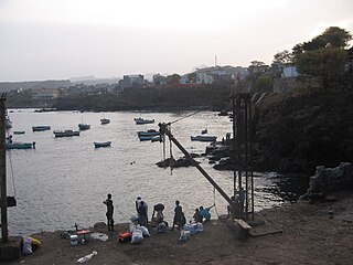
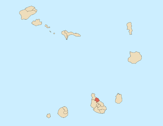
Calheta de São Miguel is a city in the northern part of the island of Santiago, Cape Verde. In 2010 its population was 3,175. It is situated on the east coast, 31 km north of the capital Praia. It is the seat of São Miguel municipality.

Santa Catarina is a concelho (municipality) of Cape Verde. It is situated in the western part of the island of Santiago. Its seat is the city of Assomada. Its population was 45,920 in 2017 (estimate). Its area is 242.6 km2.

Pedra Badejo is a city in the eastern part of the island of Santiago, Cape Verde. It is situated on the east coast, 25 km north of the island capital Praia, 8 km southeast of Calheta de São Miguel and 15 km east of Assomada. It is the seat of Santa Cruz municipality. At the 2010 census, the town had 9,859 inhabitants.

Principal is a settlement in the northern part of the island of Santiago, Cape Verde. It is part of the municipality of São Miguel. The settlement consists of several localities along the river Ribeira Principal, including Chão de Horta, Hortelão, Jaqueitão and Mato Curral. In 2010 its population was 1,193. Hortelão is 4 km north of the summit of the Serra Malagueta and 7 km northwest of Calheta de São Miguel.

Monte Grande is a settlement in the central part of the island of Fogo, Cape Verde. It is situated at about 900 m in elevation, 10 km east of the island capital São Filipe. In 2010 its population was 743. Nearby places include Monte Largo to the southeast, Patim to the southwest and Miguel Gonçalves to the northwest.

Achada Monte is a town in the northern part of the island of Santiago, Cape Verde and is part of the municipality of São Miguel. It is situated near the east coast, 8 km northwest of Calheta de São Miguel. In 2010 its population was 1,652. It is on the road connecting Praia and Tarrafal through Pedra Badejo, the EN1-ST02. The small bay Mangue de Sete Ribeiras is located east of the settlement. Ribeira Principal flows west of the village.

Miguel Gonçalves is a settlement in the central part of the island of Fogo, Cape Verde. It is situated at about 850 m elevation, 8 km east of the island capital São Filipe.

Nossa Senhora da Conceição is a freguesia of Cape Verde. It covers the southern part of the municipality of São Filipe, on the island of Fogo. The freguesia consists of the following settlements:

Cancelo is a settlement in the eastern part of the island of Santiago, Cape Verde. It is part of the municipality Santa Cruz. It is situated near the east coast, 4 km northwest of Pedra Badejo and 5 km southeast of Calheta de São Miguel. In 2010 its population was 2,042.

Tarrafal is a city in the northern part of the island of Santiago, Cape Verde. In 2010 its population was 6,656. It is a fishing port situated on the northwestern coast. It constitutes the seat of the Tarrafal Municipality.

Saltos Acima is a village in the northcentral part of the island of Santiago, Cape Verde. It is part of the municipality of Santa Catarina. In 2010 its population was 657. It is situated 5 km northeast of Assomada. To the north it borders on the settlement Pedra Serrado, which is in the municipality of São Miguel.

Espinho Branco is a village in the northern part of the island of Santiago, Cape Verde. In 2010 its population was 869. It is situated near the coast, 5 km northwest of Calheta de São Miguel. Espinho Branco is known for its community of Rabelados, a group of people who opposed reforms of the Catholic church and maintain a traditional way of life.

Ponta Verde is a seaside settlement in the northeastern part of the island of Santiago, Cape Verde. It is a suburb of the city of Calheta de São Miguel, part of the municipality of São Miguel. It is situated on the Praia-Pedra Badejo-Tarrafal Road (EN1-ST02), 1.5 km northwest of the centre of Calheta de São Miguel. In 2010 its population was 1,065.

Mato Correia is a village in the northeastern part of the island of Santiago, Cape Verde. It is part of the municipality of São Miguel. It is located southwest of Espinho Branco, 1.5 km north of Pilão Cão and 5 km northwest of São Miguel. In 2010 its population was 328.


