
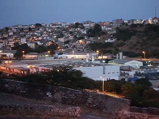
Praia, is the capital and largest city of Cape Verde, an island nation in the Atlantic Ocean west of Senegal. It lies on the southern coast of Santiago island in the Sotavento Islands group. It is the island's ferry port and is home to one of the nation's four international airports. The city centre is known as Plateau due to its location on a small plateau.

Tarrafal is a concelho (municipality) of Cape Verde. It is situated in the northern part of the island of Santiago. Its seat is the town Tarrafal. Its population was 18,565 at the 2010 census, and its area is 120.8 km2.

Santa Catarina is a concelho (municipality) of Cape Verde. It is situated in the western part of the island of Santiago. Its seat is the city of Assomada. Its population was 45,920 in 2017 (estimate). Its area is 242.6 km2.
Santa Cruz is a concelho (municipality) of Cape Verde. It is situated in the eastern part of the island of Santiago. Its seat is the city Pedra Badejo. Its population was 26,617 at the 2010 census, and its area is 112.2 km2.

Mosteiros is a concelho (municipality) of Cape Verde. Situated in the northeastern part of the island of Fogo, it covers 19% of the island area, and is home to 26% of its population. Its seat is the city Mosteiros (Igreja). Its population was 9,524 at the 2010 census, and its area is 89.45 km2.

São Lourenço dos Órgãos is a concelho (municipality) of Cape Verde. It is situated in the mountainous central part of the island of Santiago. Its seat is the city João Teves. Its population was 7,388 at the 2010 census, and its area is 36.9 km2. The municipality is bordered by Santa Cruz to the northeast, São Domingos to the south, Ribeira Grande de Santiago to the southwest and São Salvador do Mundo to the northwest. Pico de Antónia, the island's highest mountain, straddles the borders of São Lourenço dos Órgãos, São Salvador do Mundo and Ribeira Grande de Santiago.
Santa Catarina do Fogo is a concelho (municipality) of Cape Verde. Situated in the southeastern part of the island of Fogo, it covers 32% of the island area, and is home to 14% of its population. Its seat is the city Cova Figueira. The Municipality of Santa Catarina do Fogo was created in 2005; before 2005, it was a parish of the Municipality of São Filipe.

São Salvador do Mundo is a concelho (municipality) of Cape Verde. It is situated in the central part of the island of Santiago. Its seat is the city Picos. Its population was 8,677 at the 2010 census, and its area is 26.5 km2, making it the smallest municipality of Cape Verde. The municipality borders Santa Cruz to the northeast, São Lourenço dos Órgãos to the southeast, Ribeira Grande de Santiago to the southwest and Santa Catarina to the northwest.

Achadinha is a subdivision of the city of Praia in the island of Santiago, Cape Verde. Its population was 8,483 at the 2010 census. It is situated north of the city centre. Adjacent neighbourhoods include Bairro Craveiro Lopes to the south, Fazenda in the east, Achada Eugênio Lima in the west and Calabaceira in the north, on the other side of the Ribeira da Trindade.

Santíssimo Nome de Jesus is a freguesia of Cape Verde. It covers the eastern part of the municipality of Ribeira Grande de Santiago, on the island of Santiago.
São João Baptista is a freguesia of Cape Verde. It covers the western part of the municipality of Ribeira Grande de Santiago, on the island of Santiago.

São Nicolau Tolentino is a freguesia of Cape Verde. It covers the western part of the municipality of São Domingos, on the island of Santiago.
Praia is a concelho (municipality) of Cape Verde. It is situated in the southern part of the island of Santiago. Its seat is the city Praia, the capital of Cape Verde. Its area is 120.6 km2 (46.6 sq mi), and its population was 131,719 at the 2010 census. The municipality consists of one freguesia, Nossa Senhora da Graça. The city hall is located in the Platô part of the city.
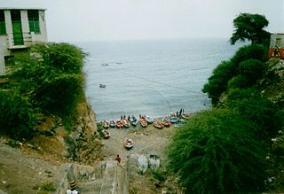
Praia Baixo is a village in the southeastern part of the island of Santiago, Cape Verde. It is part of the municipality of São Domingos and the parish of Nossa Senhora da Luz. It is situated on the east coast, 1.5 km northwest of Achada Baleia, 11 km southeast of Pedra Badejo, 10 km east of São Domingos and 16 km north of the capital Praia. In 2010 its population was 952.

Chã de Areia is a subdivision of the city of Praia in the island of Santiago, Cape Verde. Its population was 247 at the 2010 census. It is situated south and west of the city centre. Adjacent neighbourhoods include Plateau to the northeast, Achadinha to the north, Várzea to the west, Achada Santo António to the southwest and Prainha to the south. Its main streets are Avenida Combatentes da Liberdade da Patria and Avenida Cidade de Lisboa. Points of interest in Chã de Areia include the beach of Gamboa, the old port of Praia and the Cape Verdean National Archives, housed in the former customs building.

Várzea is a subdivision of the city of Praia in the island of Santiago, Cape Verde. Its population was 4,834 at the 2010 census. It is situated west of the city centre. Adjacent neighbourhoods are Bairro Craveiro Lopes to the north, Platô to the east, Achada Santo António to the south and Terra Branca to the west.
Achada Grande Frente is a subdivision of the city of Praia in the island of Santiago, Cape Verde. Its population was 4,436 at the 2010 census. It is situated east of the city centre, between the Praia Harbour to the south and the Nelson Mandela International Airport to the north. The former Francisco Mendes International Airport was located in Achada Grande Frente.
Lem Ferreira is a subdivision of the city of Praia in the island of Santiago, Cape Verde. Its population was 1,456 at the 2010 census. It is situated directly east of the city centre (Platô), on the east bank of Ribeira da Trindade. Bordering neighborhoods include Agua Funda to the northeast, Achada Grande Frente to the east and the south and Platô and Praia Negra to the west.
Moia Moia is a settlement in the eastern part of the island of Santiago, Cape Verde. It is part of the municipality of São Domingos. In 2010 its population was 205. It is situated near the east coast, 2 km southeast of Baía, 5 km northeast of Vale da Custa and 14 km northeast of Praia. It sits at an elevation of about 20 meters.


