Tarrafal is a concelho (municipality) of Cape Verde. It is situated in the northern part of the island of Santiago. Its seat is the town Tarrafal. Its population was 18,565 at the 2010 census, and its area is 120.8 km2.

Calheta de São Miguel is a city in the northern part of the island of Santiago, Cape Verde. In 2010 its population was 3,175. It is situated on the east coast, 31 km north of the capital Praia. It is the seat of São Miguel municipality.

Tarrafal de São Nicolau is a concelho (municipality) of Cape Verde. Situated in the western part of the island of São Nicolau, it covers 35% of the island area (119.8 km²), and is home to 41% of its population. Its seat is the town Tarrafal de São Nicolau.

Tarrafal de São Nicolau is a city in the western part of the island of São Nicolau, Cape Verde. With a population of 3,733, it is the most populous settlement of the island. It is the seat of the Tarrafal de São Nicolau Municipality, and the main port of the island. It is situated on the west coast, 9 km southwest of Ribeira Brava.

Atalaia is a settlement in the northern part of the island of Fogo, Cape Verde. Its population was 700 in 2010. It is situated near the coast, 6 km west of Mosteiros and 19 km northeast of the island capital São Filipe. The municipal boundary with São Filipe is to the west. Nearby settlements area Ribeira Ilhéu to the east and Campanas Baixo to the west. The festival of Saint John is celebrated every June 24.

Principal is a settlement in the northern part of the island of Santiago, Cape Verde. It is part of the municipality of São Miguel. The settlement consists of several localities along the river Ribeira Principal, including Chão de Horta, Hortelão, Jaqueitão and Mato Curral. In 2010 its population was 1,193. Hortelão is 4 km north of the summit of the Serra Malagueta and 7 km northwest of Calheta de São Miguel.
Nossa Senhora da Lapa is a freguesia of Cape Verde. It covers the smaller northwestern part of the municipality of Ribeira Brava, on the island of São Nicolau.
Belém is a settlement in the eastern part of the island of São Nicolau, Cape Verde. It is situated 9 km east of Ribeira Brava.
São Pedro Apóstolo is a freguesia of Cape Verde. It covers the western part of the municipality of Ribeira Grande, on the island of Santo Antão.
Cachaço is a settlement in the northwestern part of the island of São Nicolau, Cape Verde. It is situated 3 km southwest of Fajã de Baixo and 5 km west of Ribeira Brava. It lies on the national road from Tarrafal de São Nicolau to Ribeira Brava (EN1-SN01). Cachaço lies at about 700 m elevation, at the northeastern foot of Monte Gordo, and partly within the Monte Gordo Natural Park. Several rivers have their source near Cachaço, including the north-flowing Ribeira Grande and the east-flowing Ribeira Brava.
Fajã de Baixo is a town in the northern part of the island of São Nicolau, Cape Verde. It is situated 2 km south of Estância de Brás and 5 km northwest of Ribeira Brava.
Juncalinho is a town in the eastern part of the island of São Nicolau, Cape Verde. It is situated on the north coast, 17 km east of Ribeira Brava. The local football club is FC Belo Horizonte.
Praia Branca is a town in the northwestern part of the island of São Nicolau, Cape Verde. It is part of the municipality of Tarrafal de São Nicolau. Its population at the 2010 census was 521. It is situated 2 km from the coast, 10 km northwest of Ribeira Brava.

Ribeira da Vinha is a village in the central part of the island of Sao Vicente, Cape Verde. It is situated in the plain southwest of the island capital Mindelo, approximately 3 km from the city centre.

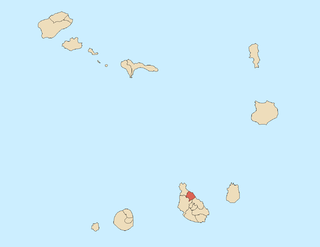
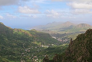
Ribeira Brava is a city on the island of São Nicolau, Cape Verde. It is the seat of the Ribeira Brava Municipality. Its population was 1,936 at the 2010 census. The town is situated in the valley of the river Ribeira Brava, east of the main mountain range of the island. The name of the river is Portuguese for "rough stream", referring to the violent behaviour of the river during rains. The city has a colonial look with Portuguese style buildings, charming parks and gardens, small winding streets, and steep hills.

João Teves is a city in the central part of the island of Santiago, Cape Verde. It is situated 19 km northwest of the capital Praia, on the national road from Praia to Assomada (EN1-ST01). It is the seat of São Lourenço dos Órgãos municipality. A source river of the Ribeira Seca flows through the town.
Ribeira Julião is a village in the central part of the island of Sao Vicente, Cape Verde. In 2010 its population was 611. It is situated in the valley of the stream Ribeira de Julião, south of the island capital Mindelo, 3.5 km from the city centre. An adjacent neighbourhood of Mindelo is named Ribeira de Julião.
Talho is a settlement in the central part of the island of São Nicolau, Cape Verde. It is located in the valley of Ribeira Brava, 1 km west of the city Ribeira Brava. In 2010 its population was 308. It is part of the municipality of Ribeira Brava and the parish of Nossa Senhora do Rosário.
Ribeira dos Calhaus is a settlement in the western part of the island of São Nicolau, Cape Verde. It is part of the municipality of Tarrafal de São Nicolau. It is situated in a valley northwest of Monte Gordo, 3 km southeast of Praia Branca and 7 km north of Tarrafal de São Nicolau.
Levada is a village in the interior of the island of Santiago, Cape Verde. It is part of the municipality of São Lourenço dos Órgãos. It is situated 3 km east of João Teves, 5 km north of São Domingos and 18 km north of the capital Praia. In 2010 its population was 234. The village is on the upper course of the river Ribeira Seca, west of the Poilão Reservoir.