
Camp Verde is a town in Yavapai County, Arizona, United States. As of the 2010 census, the population of the town is 10,873.

Três Corações is a municipality in the south of Minas Gerais state in Brazil. As of 2013, the city population was about 80,000, making it one of the largest cities in the south of Minas Gerais. The city is geographically located close to the circumcenter of the three largest metropolitan areas in Brazil. Thus, making it a strategic hub for commerce. The city is internationally famous for being the birthplace of the football legend Pelé.

Fogo is an island in the Sotavento group of Cape Verde. Its population is 35,837 (2015), with an area of 476 km². It reaches the highest altitude of all the islands in Cape Verde, rising to 2,829 metres above sea level at the summit of its active volcano, Pico do Fogo.

Santa Luzia is an island of the Barlavento archipelago in Cape Verde located between São Nicolau and São Vicente, the channel of Santa Luzia separates the island of São Vicente and is 8 km wide. The area is 34.2 km². Like all Cape Verdean islands, it is of volcanic origin. The highest point is Topona. Santa Luzia is 12.4 km long and 5.3 km wide.

Boa Vista, also written as Boavista, is a desert-like island that belongs to the Cape Verde Islands. At 631.1 km2 (243.7 sq mi), it is the third largest island of the Cape Verde archipelago.
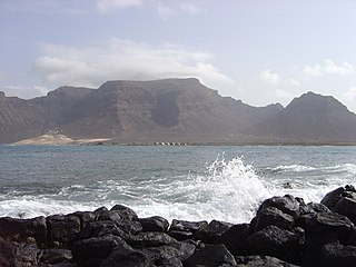
Monte Verde is a mountain in the eastern part of the island of São Vicente, Cape Verde. At 744 m elevation, it is the island's highest point. The mountain is located 6 km (4 mi) east of the city centre of Mindelo.
Pedra Badejo is a city in the eastern part of the island of Santiago, Cape Verde. It is situated on the east coast, 25 km north of the island capital Praia, 8 km southeast of Calheta de São Miguel and 15 km east of Assomada. It is the seat of Santa Cruz municipality. At the 2010 census, the town had 9,859 inhabitants.

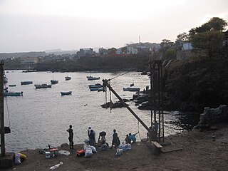
Ponta do Sol is the northernmost city on the island of Santo Antão and Cape Verde. It is situated on the coast, 4 km northwest of Ribeira Grande and 20 km north of the island capital Porto Novo. It is the seat of Ribeira Grande municipality.

Tope de Coroa is a mountain on the island of Santo Antão's, Cape Verde. At 1,979 m elevation, it is the highest point of the island. It is in the western part of the island, 25 km west of the island capital Porto Novo. The mountain is entirely of volcanic origin. The area is the source of several streams including Ribeira de Monte Trigo which flows westward to Monte Trigo.

Monte Penoso is a mountain on the island of Maio, Cape Verde. At 436 m elevation, it is the island highest point. It is situated in the eastern part of the island, 3 km southwest of Pedro Vaz and 13 km northeast of the island capital Porto Inglês. The mountain is of volcanic origin. It is part of the protected landscape Monte Penoso and Monte Branco, which covers 11.17 km2 (4.31 sq mi).

Figueira das Naus is a settlement in the western part of the island of Santiago, Cape Verde. It is part of the municipality of Santa Catarina. In 2010 its population was 1,157. It is situated 11 km south of Tarrafal and 12 km northwest of Assomada. It is situated on the secondary road connecting Fundura and Ribeira da Prata.

Pombas is a city in the northeastern part of the island of Santo Antão, Cape Verde. It is the seat of the municipality Paul. It is situated on the coast, at the mouth of the Ribeira do Paul, 7 km (4.3 mi) southeast of Ribeira Grande and 15 km (9.3 mi) north of the island capital Porto Novo. The national roads EN1-SA02 and EN1-SA03 connect Pombas with Ribeira Grande and Porto Novo, respectively. Pombas was elevated from town to city in 2010.
Morro is a settlement in the west of the island of Maio in Cape Verde. It is located 5 km north of the island capital Porto Inglês and 6 km south of Calheta. As of the 2010 census, its population was 310. The beach north of the village, Praia do Morro, is a 6.66 km2 nature reserve.

São Jorge is a settlement in the central part of the island of Santiago, Cape Verde. It is part of the São Lourenço dos Órgãos municipality. In 2010 its population was 6. It is situated 2.5 km southwest of João Teves and 4 km southeast of Picos. Its elevation is 319 meters.
Campina Verde is a municipality in the north of the Brazilian state of Minas Gerais. As of 2007 the population was 18,680 in a total area of 3,663 km². It became a municipality in 1938.

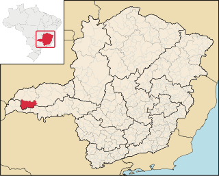
São Francisco de Sales is a municipality in the west of the Brazilian state of Minas Gerais. As of 2007 the population was 5,167 in a total area of 1,129 km². It became a municipality in 1962.

São Domingos is a city in the central part of the island of Santiago, Cape Verde. In 2010 its population was 2,818. It is the seat of the São Domingos Municipality. It is situated 13 km southeast of Assomada and 13 km northwest of the capital Praia, along the national road from Praia to Assomada (EN1-ST01). The settlement appeared in the 1747 map by Jacques-Nicolas Bellin as St. Domingo.
São Martinho Grande is a settlement in the southern part of the island of Santiago, Cape Verde. It is part of the municipality Ribeira Grande de Santiago. It is located 4 km east from Cidade Velha and 6.5 km west of Praia city centre. The national road EN1-ST05 passes north of the village. 1.5 km south of the village is a small bay of the Atlantic Ocean, Calheta de São Martinho. It was mentioned as "Kalyete de S. Martin" on the 1747 map by Jacques-Nicolas Bellin.


