
São Domingos is a concelho (municipality) of Cape Verde. It is situated in the southeastern part of the island of Santiago. Its seat is the city São Domingos. Its population was 13,699 at the 2010 census, and its area is 147.5 km2.

São Lourenço dos Órgãos is a concelho (municipality) of Cape Verde. It is situated in the mountainous central part of the island of Santiago. Its seat is the city João Teves. Its population was 7,388 at the 2010 census, and its area is 36.9 km2. The municipality is bordered by Santa Cruz to the northeast, São Domingos to the south, Ribeira Grande de Santiago to the southwest and São Salvador do Mundo to the northwest. Pico de Antónia, the island's highest mountain, straddles the borders of São Lourenço dos Órgãos, São Salvador do Mundo and Ribeira Grande de Santiago.
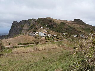
Rui Vaz is a settlement in the central part of the island of Santiago, Cape Verde. In 2010 its population was 1,078. It is situated at 809 m elevation, 2 km south of São Jorge dos Órgãos and 4 km west of São Domingos. It is part of the municipality of São Domingos.

Banana is a settlement in the central part of the island of Santiago, Cape Verde. It is situated 3 km northeast of São Domingos.
Água de Gato is a settlement in the central part of the island of Santiago, Cape Verde. In 2010 its population was 957. It is situated at about 400 m elevation, 2 km northwest of São Domingos and 2 km east of Rui Vaz.
Nossa Senhora da Luz is a freguesia of Cape Verde. It covers the eastern part of the municipality of São Domingos, on the island of Santiago.

São Nicolau Tolentino is a freguesia of Cape Verde. It covers the western part of the municipality of São Domingos, on the island of Santiago.
São Francisco is a subdivision of the city of Praia in the island of Santiago, Cape Verde. Its population was 570 at the 2010 census. It is situated 7 km north of the city centre. 3.5 km to its east is the São Francisco Bay, and 2.5 km to its northeast the village Vale da Custa, part of the municipality of São Domingos.
Codé di Dona, nickname of Gregório Vaz, was a Cape Verdean musician and composer.
Praia Baixo is a village in the southeastern part of the island of Santiago, Cape Verde. It is part of the municipality of São Domingos and the parish of Nossa Senhora da Luz. It is situated on the east coast, 1.5 km northwest of Achada Baleia, 11 km southeast of Pedra Badejo, 10 km east of São Domingos and 16 km north of the capital Praia. In 2010 its population was 952.
Milho Branco is a village in the southeastern part of the island of Santiago, Cape Verde. It is situated 2 km north of Ribeirão Chiqueiro, 5 km east of the city São Domingos and 12 km north of the capital Praia. The national road EN1-ST02 from Ribeirão Chiqueiro to Tarrafal via Pedra Badejo passes through the village. It is part of the municipality of São Domingos. In 2010 its population was 607.
Vale da Custa is a village in the southeastern part of the island of Santiago, Cape Verde. It is situated 2 km northwest of São Francisco Bay, 6 km southeast of Ribeirão Chiqueiro and 9 kilometres northeast of the capital Praia. It is part of the municipality of São Domingos and the parish of Nossa Senhora da Luz. In 2010 its population was 378.
Levada is a village in the interior of the island of Santiago, Cape Verde. It is part of the municipality of São Lourenço dos Órgãos. It is situated 3 km east of João Teves, 5 km north of São Domingos and 18 km north of the capital Praia. In 2010 its population was 234. The village is on the upper course of the river Ribeira Seca, west of the Poilão Reservoir.
The Santiago South Zone Cup is the oldest regional cup competition in Cape Verde and is played during the season in the south of island of Santiago, Cape Verde consisting the municipalities of Praia, Ribeira Grande de Santiago and São Domingos. It consists of all the clubs from all the two regional divisions and are divided into about six rounds. The cup competition is organized by the Santiago South Regional Football Association .The cup winner competed in the regional super cup final in the following season. Since 2007, the winner qualifies into the Cape Verdean Cup which were been canceld from 2012 to 2017 due to financial and scheduling reasons.
Achada Baleia is a settlement in the eastern part of the island of Santiago, Cape Verde. It is part of the municipality of São Domingos. In 2010 its population was 376. It is situated near the east coast, 1.5 km southeast of Praia Baixo, 2 km northwest of Baía and 15 km northeast of Praia. It sits at an elevation of about 50 meters.
Moia Moia is a settlement in the eastern part of the island of Santiago, Cape Verde. It is part of the municipality of São Domingos. In 2010 its population was 205. It is situated near the east coast, 2 km southeast of Baía, 5 km northeast of Vale da Custa and 14 km northeast of Praia. It sits at an elevation of about 20 meters.
Baía is a settlement in the eastern part of the island of Santiago, Cape Verde. It is part of the municipality of São Domingos. In 2010 its population was 489. It is situated near the east coast, 2 km southeast of Achada Baleia, 2 km northwest of Moia Moia and 14 km northeast of Praia. It sits at an elevation of about 20 meters. The settlement consists of several localities, including Achada Baixo, Castelinho and Covão Santana. The ruined Gothic church of Nossa Senhora da Luz, which was part of the 15th century Portuguese settlement Alcatrazes, stands at the shore near Baía.
Ribeirão Chiqueiro is a village in the southcentral part of the island of Santiago, Cape Verde. It is part of the municipality of São Domingos. It is 5 km southeast of the municipal seat São Domingos. In 2010 its population was 775. Its elevation is around 270 m. The national road EN1-ST01 passes near the village.
Dacabalaio is a village in the southcentral part of the island of Santiago, Cape Verde. It is part of the municipality of São Domingos. It is 2 km south of Rui Vaz and 4 km southwest of the municipal seat São Domingos. In 2010 its population was 47. Its elevation is about 710 m.


