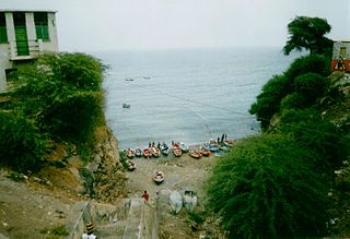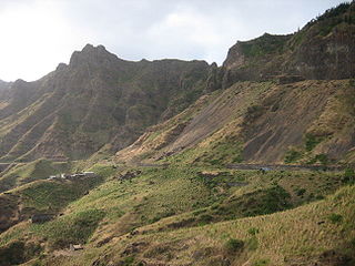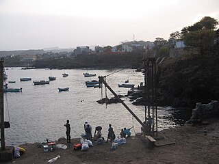
Santa Cruz is a concelho (municipality) of Cape Verde. It is situated in the eastern part of the island of Santiago. Its seat is the city Pedra Badejo. Its population was 26,617 at the 2010 census, and its area is 112.2 km2.

Achada Monte is a town in the northern part of the island of Santiago, Cape Verde and is part of the municipality of São Miguel. It is situated near the east coast, 8 km northwest of Calheta de São Miguel. In 2010 its population was 1,652. It is on the road connecting Praia and Tarrafal through Pedra Badejo, the EN1-ST02. The small bay Mangue de Sete Ribeiras is located east of the settlement. Ribeira Principal flows west of the village.

Cancelo is a settlement in the eastern part of the island of Santiago, Cape Verde. It is part of the municipality Santa Cruz. It is situated near the east coast, 4 km northwest of Pedra Badejo and 5 km southeast of Calheta de São Miguel. In 2010 its population was 2,042.

Pedra de Lume is a village in the northeastern part of the island of Sal, Cape Verde. The village is situated on the east coast, about 5 km east of the island capital Espargos. It has a small port and a lighthouse, Farol de Pedra de Lume.

Tarrafal is a city in the northern part of the island of Santiago, Cape Verde. In 2010 its population was 6,656. It is a fishing port situated on the northwestern coast. It constitutes the seat of the Tarrafal Municipality.

Montanha is a settlement in the central part of the island of Santiago, Cape Verde. It is situated 2 km north of João Teves and 8 km southwest of Pedra Badejo. The area is intensively farmed; mainly maize, beans and sugar-cane.
The Lagoas de Pedra Badejo is an area of wetlands on the island of Santiago, Cape Verde. It is a 666-hectare (1,650-acre) site comprising two coastal lagoons at the estuaries of the rivers Ribeira dos Picos and Ribeira Seca, and the entire basin of the latter, including the reservoir Barragem de Poilão. It lies south of the town of Pedra Badejo, on the north-east coast of the island. The lagoons are of great ecological value for birds as they contain fresh or only slightly brackish water. They have been recognised as a wetland of international importance by designation under the Ramsar Convention since 2005.

Praia Baixo is a village in the southeastern part of the island of Santiago, Cape Verde. It is part of the municipality of São Domingos and the parish of Nossa Senhora da Luz. It is situated on the east coast, 1.5 km northwest of Achada Baleia, 11 km southeast of Pedra Badejo, 10 km east of São Domingos and 16 km north of the capital Praia. In 2010 its population was 952.

Milho Branco is a village in the southeastern part of the island of Santiago, Cape Verde. It is situated 2 km north of Ribeirão Chiqueiro, 5 km east of the city São Domingos and 12 km north of the capital Praia. The national road EN1-ST02 from Ribeirão Chiqueiro to Tarrafal via Pedra Badejo passes through the village. It is part of the municipality of São Domingos. In 2010 its population was 607.

Estádio Municipal 25 de Julho is a multi-purpose stadium in the town of Pedra Badejo in the municipality of Santa Cruz on the east of Santiago Island, Cape Verde, it is hundreds of meters west of the center and the Atlantic and hundreds of meters north of the old Praia-Pedra Badejo-Tarrafal highway. The stadium is named after one of the holidays celebrated on July 25. It is currently used mostly for football matches. The stadium holds 1,00 people and its dimensions is 100 x 64 meters. It is operated by the Santiago North Regional Football Association (ARFSN). The stadium is home to Pedra Badejo's best clubs including Scorpion Vermelho, Benfica and Desportivo. All clubs participate in the Santiago Island League North Zone.

EN1-ST01 is a first class national road on the island of Santiago, Cape Verde. It runs from the capital Praia in the south to Tarrafal in the north, through the mountainous interior of the island. It is 61 km long. The main intersections are:

Veneza is a settlement in the northeastern part of the island of Santiago, Cape Verde. It is part of the municipality of São Miguel. It is a suburb of the city of Calheta de São Miguel, north of the city centre. It is situated on the coast, along the Praia-Pedra Badejo-Tarrafal Road (EN1-ST02). In 2010 its population was 1,375.

Ponta Verde is a seaside settlement in the northeastern part of the island of Santiago, Cape Verde. It is a suburb of the city of Calheta de São Miguel, part of the municipality of São Miguel. It is situated on the Praia-Pedra Badejo-Tarrafal Road (EN1-ST02), 1.5 km northwest of the centre of Calheta de São Miguel. In 2010 its population was 1,065.

Ribeira Seca is the largest stream of the island of Santiago in Cape Verde. It is 18 km (11 mi) long and its basin area is 71.5 km2 (27.6 sq mi). Located in the eastern part of the island, it flows through the municipalities of São Lourenço dos Órgãos and Santa Cruz. Its source is near the highest point of the island, Pico de Antónia, from where it flows to the east to João Teves. It turns to the northeast and flows into the Atlantic Ocean at Achada Fazenda, 2 km southeast of Pedra Badejo. It is called Ribeira de Pico da Antónia in its uppermost part, and Ribeira de Lage near João Teves.

Achada Ponta is a settlement in the eastern part of the island of Santiago, Cape Verde. It is part of the municipality Santa Cruz. It is located near the east coast, 2 km southeast of Achada Fazenda and 5 kilometers southeast of Pedra Badejo. In 2010 its population was 403.

Santa Cruz is a settlement in the eastern part of the island of Santiago, Cape Verde. It is part of the municipality of Santa Cruz. It is located 2 km south of Cancelo and 3 km west of Pedra Badejo, on the national road to Tarrafal (EN1-ST02). In 2010 its population was 2,019.


