Milho Branco do Norte

Last updated
Milho Branco (do Norte)
Settlement
Cape Verde location map.svg
Red pog.svg
Milho Branco (do Norte)
Coordinates: 15°14′15″N23°43′42″W / 15.2376°N 23.7283°W / 15.2376; -23.7283 Coordinates: 15°14′15″N23°43′42″W / 15.2376°N 23.7283°W / 15.2376; -23.7283
Country Cape Verde
Island Santiago
Municipality Tarrafal
Civil parish Santo Amaro Abade
Population (2010) [1]
  Total 165

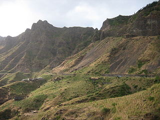
Milho Branco do Norte, locally and commonly as Milho Branco, also as Milho Branco sobre Mau Passo for outsiders is a settlement and a plateau in the northcentral part of the island of Santiago, Cape Verde and is part of the municipality of Tarrafal. Its 2010 population was 165. It is located about 5 km southeast of Tarrafal and is linked with the EN1-ST01 with a branch road. In 1983, the Primary Route 1 (then LBRS1) was rerouted into the settlement, running through the middle of Serra Malagueta and the then branch road that connected with Achada Longueira as well as Chão Bom and Lagoa. [2]

Santiago, Cape Verde largest island of Cape Verde

Santiago is the largest island of Cape Verde, its most important agricultural centre and home to half the nation’s population. Part of the Sotavento Islands, it lies between the islands of Maio and Fogo. It was the first of the islands to be settled: the town of Ribeira Grande was founded in 1462. Santiago is home to the nation's capital city of Praia.

Cape Verde Country comprising ten islands off the Northwest coast of Africa

Cape Verde or Cabo Verde, officially the Republic of Cabo Verde, is an island country spanning an archipelago of 10 volcanic islands in the central Atlantic Ocean. It forms part of the Macaronesia ecoregion, along with the Azores, Canary Islands, Madeira, and the Savage Isles. In ancient times these islands were referred to as "the Islands of the Blessed" or the "Fortunate Isles". Located 570 kilometres (350 mi) west of the Cape Verde Peninsula off the coast of Northwest Africa, the islands cover a combined area of slightly over 4,000 square kilometres (1,500 sq mi).

Tarrafal, Cape Verde (municipality) Municipality in Santiago, Cape Verde

Tarrafal is a concelho (municipality) of Cape Verde. It is situated in the northern part of the island of Santiago. Its seat is the town Tarrafal. Its population was 18,565 at the 2010 census, and its area is 120.8 km2.

As there is Milho Branco in the east of São Domingos, secondarily known as Minho Branco, to outsiders, the settlement near Chão Bom is known as Milho Branco do Norte or Milho Branco sobre Mau Passo.

Milho Branco Settlement in Santiago, Cape Verde

Milho Branco is a village in the southeastern part of the island of Santiago, Cape Verde. It is situated 2 km north of Ribeirão Chiqueiro, 5 km east of the city São Domingos and 12 km north of the capital Praia. The national road EN1-ST02 from Ribeirão Chiqueiro to Tarrafal via Pedra Badejo passes through the village. It is part of the municipality of São Domingos. In 2010 its population was 607.

São Domingos, Cape Verde (municipality) Municipality in Santiago, Cape Verde

São Domingos is a concelho (municipality) of Cape Verde. It is situated in the southeastern part of the island of Santiago. Its seat is the city São Domingos. Its population was 13,699 at the 2010 census, and its area is 147.5 km2.

Chão Bom Settlement in Santiago, Cape Verde

Chão Bom is a settlement in the northern part of the island of Santiago, Cape Verde. It is situated near the west coast, 3 km southeast of Tarrafal on the main road (EN1-ST01) south to Assomada and Praia. In 2010 its population was 5,166. The Tarrafal prison camp was situated north of Chão Bom. The stadium Estádio de Mangue is in the northwestern part in the communal limits. Silvino Lopes Évora, a writer, poet, journalist and a university professor is native to Chão Bom.

The settlement is named a white mill that mainly a sugar mill. Sugar mills, even in that area are dominant even today.

It is midway near Ribeira de Mau Passo, a stream flowing northwest into the Atlantic at Baía de Chão Bom.

Atlantic Ocean Ocean between Europe, Africa and the Americas

The Atlantic Ocean is the second largest of the world's oceans, with an area of about 106,460,000 square kilometers. It covers approximately 20 percent of the Earth's surface and about 29 percent of its water surface area. It separates the "Old World" from the "New World".

Most of the area are hilly and mountainous being, it forms a northernmost part of the Serra Malagueta ranges. Agriculture is its main economy.

In the mid-20th century, the settlement had a large Rabelados population.

The Rabelados are a religious community primarily found in the interior of the island of Santiago of Cape Verde. They were among the groups which revolted against the liturgical reforms of the Catholic Church introduced in the 1940s, isolating themselves from the rest of society.

Related Research Articles

São Nicolau, Cape Verde island of Cape Verde

São Nicolau is one of the Barlavento (Windward) islands of Cape Verde. It is located between the islands of Santa Luzia and Sal. Its population is 12,424 (2015), with an area of 343 km². The main towns are Ribeira Brava and Tarrafal de São Nicolau.

Tarrafal de São Nicolau (municipality) Municipality in São Nicolau, Cape Verde

Tarrafal de São Nicolau is a concelho (municipality) of Cape Verde. Situated in the western part of the island of São Nicolau, it covers 35% of the island area (119.8 km²), and is home to 41% of its population. Its seat is the town Tarrafal de São Nicolau.

Tarrafal de São Nicolau, Cape Verde Settlement in São Nicolau, Cape Verde

Tarrafal de São Nicolau is a city in the western part of the island of São Nicolau, Cape Verde. With a population of 3,733, it is the most populous settlement of the island. It is the seat of the Tarrafal de São Nicolau Municipality, and the main port of the island. It is situated on the west coast, 9 km southwest of Ribeira Brava.

Trás os Montes, Cape Verde Settlement in Santiago, Cape Verde

Trás os Montes is a settlement in the northern part of the island of Santiago, Cape Verde. In 2010 its population was 464. It is situated 4 km northeast of Tarrafal.

Achada Tenda Settlement in Santiago, Cape Verde

Achada Tenda is a town in the northern part of the island of Santiago, Cape Verde. In 2010 its population was 1,242. It is situated on the east coast, 10 km southeast of Tarrafal. The small bay Porto Formoso is situated near the town.

Ribeira da Prata Settlement in Santiago, Cape Verde

Ribeira da Prata is a town in the northern part of the island of Santiago, Cape Verde belonging to the municipality of Tarrafal. In 2010 its population was 1,009. It was mentioned as Rivera de Prata in the 1747 map by Jacques-Nicolas Bellin.

Achada Monte Settlement in Santiago, Cape Verde

Achada Monte is a town in the northern part of the island of Santiago, Cape Verde and is part of the municipality of São Miguel. It is situated near the east coast, 8 km northwest of Calheta de São Miguel. In 2010 its population was 1,652. It is on the road connecting Praia and Tarrafal through Pedra Badejo, the EN1-ST02. The small bay Mangue de Sete Ribeiras is located east of the settlement. Ribeira Principal flows west of the village.

Figueira das Naus Settlement in Santiago, Cape Verde

Figueira das Naus is a settlement in the western part of the island of Santiago, Cape Verde. It is part of the municipality of Santa Catarina. In 2010 its population was 1,157. It is situated 11 km south of Tarrafal and 12 km northwest of Assomada. It is situated on the secondary road connecting Fundura and Ribeira da Prata.

Tarrafal de Monte Trigo Settlement in Santo Antão, Cape Verde

Tarrafal de Monte Trigo is a settlement in the southwestern part of the island of Santo Antão, Cape Verde. In 2010 its population was 841. It is situated on the coast, 27 km west of the island capital Porto Novo. The settlement was mentioned as Terrafal in the 1747 map by Jacques-Nicolas Bellin.

Monte Graciosa mountain in Cape Verde

Monte Graciosa is a mountain in the northern part of the island of Santiago in Cape Verde. It lies 2.5 km north of the town of Tarrafal, overlooking the Baía de Tarrafal. Its elevation is 643 m. Towards the west it ends in the headland of Ponta Preta. It is part of a larger proposed natural park. The mountain is of volcanic origin, composed of phonolite and rich in feldspar and olivine.

Ribeira dos Calhaus Settlement in São Nicolau, Cape Verde

Ribeira dos Calhaus is a settlement in the western part of the island of São Nicolau, Cape Verde. It is part of the municipality of Tarrafal de São Nicolau. It is situated in a valley northwest of Monte Gordo, 3 km southeast of Praia Branca and 7 km north of Tarrafal de São Nicolau.

Serra Malagueta (village) Settlement in Santiago, Cape Verde

Serra Malagueta is a settlement in the northwestcentral part of the island of Santiago, Cape Verde. It is part of the municipality of Santa Catarina. It is situated on the main road between Assomada and Tarrafal (EN1-ST01), 1 km south of Curral Velho, 3 km (1.9 mi) north of Fundura and 11 km (6.8 mi) north of Assomada. In 2010 its population was 572. The main village, Locotano, sits at about 800 m elevation, northwest of the summit of Serra Malagueta, and lies partly in the Serra Malagueta Natural Park.

Ponta Verde (Santiago) Settlement in Santiago, Cape Verde

Ponta Verde is a seaside settlement in the northeastern part of the island of Santiago, Cape Verde. It is a suburb of the city of Calheta de São Miguel, part of the municipality of São Miguel. It is situated on the Praia-Pedra Badejo-Tarrafal Road (EN1-ST02), 1.5 km northwest of the centre of Calheta de São Miguel. In 2010 its population was 1,065.

Achada Longueira Settlement in Santiago, Cape Verde

Achada Longueira is a settlement in the northern part of the island of Santiago, Cape Verde. It is part of the municipality of Tarrafal. In 2010, its population was 520. It is located about 7 kilometres (4.3 mi) southeast of Tarrafal, on the Praia-Assomada-Tarrafal Road (EN1-ST01).

Figueira Muita Settlement in Santiago, Cape Verde

Figueira Muita is a settlement in the northern part of the island of Santiago, Cape Verde. It is part of the municipality of Tarrafal. In 2010 its population was 160. It is located about 2 km south of Ribeira da Prata and 8 km south of Tarrafal.

Mancholy Settlement in Santiago, Cape Verde

Mancholy is a settlement in the northwestern part of the island of Santiago, Cape Verde. It is part of the municipality of Santa Catarina. In 2010 its population was 903. It is situated 4 km northwest of Assomada, on the road to Tarrafal (EN1-ST01).

Curral Velho (Santiago) Settlement in Santiago, Cape Verde

Curral Velho is a settlement in the northern part of the island of Santiago, Cape Verde. It is part of the municipality of Tarrafal. In 2010 its population was 358. It is located 1 km north of Locotano and 11 km southeast of Tarrafal, on the Praia-Assomada-Tarrafal Road (EN1-ST01).

References

  1. "2010 Census results". Instituto Nacional de Estatística Cabo Verde (in Portuguese). 17 March 2014.
  2. Michel Lesourd, État et société aux îles du Cap-Vert : alternatives pour un petit État insulaire [State and Society in the Cape Verde Islands: Alterantives for a Small Island State], Karthala, Paris, 1996, p. 163 ISBN   2-86537-625-7