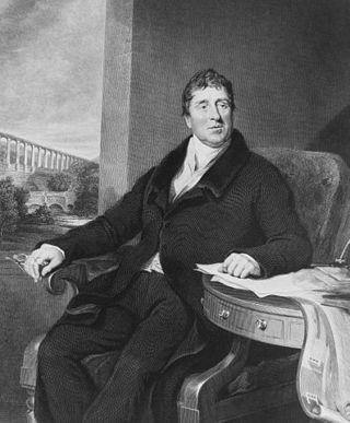
Thomas Telford was a Scottish civil engineer. After establishing himself as an engineer of road and canal projects in Shropshire, he designed numerous infrastructure projects in his native Scotland, as well as harbours and tunnels. Such was his reputation as a prolific designer of highways and related bridges, he was dubbed the 'Colossus of Roads', and, reflecting his command of all types of civil engineering in the early 19th century, he was elected as the first president of the Institution of Civil Engineers, a post he held for 14 years until his death.

The River Severn, at 220 miles (354 km) long, is the longest river in Great Britain. It is also the river with the most voluminous flow of water by far in all of England and Wales, with an average flow rate of 107 m3/s (3,800 cu ft/s) at Apperley, Gloucestershire. It rises in the Cambrian Mountains in mid Wales, at an altitude of 2,001 feet (610 m), on the Plynlimon massif, which lies close to the Ceredigion/Powys border near Llanidloes. The river then flows through Shropshire, Worcestershire and Gloucestershire. The county towns of Shrewsbury, Worcester and Gloucester lie on its course.

Shropshire is a ceremonial county in the West Midlands of England, on the border with Wales. It is bordered by Cheshire to the north, the Welsh county of Wrexham to the north and northwest, Staffordshire to the east, Worcestershire to the southeast, Herefordshire to the south, and the Welsh county of Powys to the west. The largest settlement is Telford, while Shrewsbury is the county town.

Bridgnorth is a town and civil parish in Shropshire, England. The River Severn splits it into High Town and Low Town, the upper town on the right bank and the lower on the left bank of the River Severn. The population at the 2011 Census was 12,079.
The year 1795 in architecture involved some significant events.

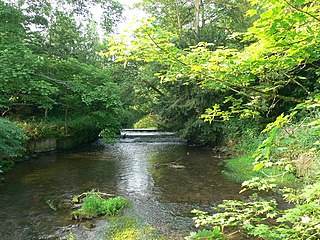
The River Perry is a river in Shropshire, England. It rises near Oswestry and flows south to meet the River Severn above Shrewsbury. Along its 24 miles (39 km) length, its level drops by some 320 feet (95 m). The channel has been heavily engineered, both to enable water mills to be powered by it, and to improve the drainage of the surrounding land. There were at least seven corn mills in the 1880s, and the last one remained operational until 1966. The middle section of the river crosses Baggy Moor, where major improvements were made in 1777 to drain the moor. The scheme was one of the largest to enclose and improve land in North Shropshire, and the quality of the reclaimed land justified the high cost. A section of the river bed was lowered in the 1980s, to continue the process.

St George's Bridge was a bridge over the River Severn in Shrewsbury, England; so named as it was close to the medieval St George's Hospital. It connected Frankwell, an old suburb of the town, to the town centre via Mardol. The gate on the town side was called Mardol Gate and is located where the Mardol Quay Gardens are. The gate on the other side was called Welsh Gate or St George's Gate. The bridge, sometimes now known as the Old Welsh Bridge, was demolished in 1795 and was replaced with the Welsh Bridge.

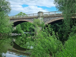
The Welsh Bridge is a masonry arch viaduct in the town of Shrewsbury, England, which crosses the River Severn. It connects Frankwell with the town centre. It is a Grade II* listed building.
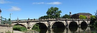
The English Bridge is a masonry arch viaduct, crossing the River Severn in Shrewsbury, Shropshire. The present bridge is a 1926 rebuilding and widening of John Gwynn's design, completed in 1774. A bridge is known to have stood at this spot since at least Norman times. Historically, it was known as the "Stone Bridge". It is a Grade II* listed building.

Longdon-upon-Tern is a village in the civil parish of Rodington, in the unitary district of Telford and Wrekin, in Shropshire, England. It is approximately 7 miles (11 km) east of Shrewsbury and 7 miles (11 km) north-west of Telford. Longdon-Upon-Tern is situated on the River Tern, a tributary of the River Severn. In 1971, the parish had a population of 127.

Fitz is a small village and former civil parish, now in the parish of Pimhill, in Shropshire, England. It is close to the River Severn, downstream from Montford Bridge and upstream of Shelton, near Shrewsbury. In 1931 the parish had a population of 241. On 1 April 1934 the parish was abolished to form Pimhill, part also went to Montford.

Jackfield is a village in the Telford and Wrekin borough of Shropshire, England, lying on the south bank of River Severn in the Ironbridge Gorge, downstream from Ironbridge. Like many of the settlements in the area, it is notable for its place in the Industrial Revolution.

Montford is a small village and parish in Shropshire, England.

Cound is a village and civil parish on the west bank of the River Severn in the English county of Shropshire, about 7 miles south east of the county town Shrewsbury. Once a busy and industrious river port Cound has now reverted to a quiet rural community and dormitory village, for commuters to the commercial centres of Shrewsbury and Telford.
Coleham is a district of the town of Shrewsbury in Shropshire, England. It is located just south, over the River Severn, from Shrewsbury town centre.

The Albert Edward Bridge is a railway bridge spanning the River Severn at Coalbrookdale in Shropshire, England.

Shrawardine is a small village and former civil parish, now in the parish of Montford, in the Shropshire district, in the ceremonial county of Shropshire, England. It is 5.9 miles (9.5 km) outside Shrewsbury. In 1931 the parish had a population of 176. On 1 April 1934 the parish was abolished and merged with Montford.
Cound Brook is a tributary of the River Severn in Shropshire, England, running to south of the county town Shrewsbury. The Cound Brook rises in the Stretton Hills, and enters the River Severn at Eyton on Severn after winding its way for 22 miles (35 km) across the southern Shropshire-Severn plain. This length is measured from high on the Long Mynd.

John Carline was an 18th-century English bridge-builder. Both his son (1758-1834) and grandson (1792-1862) continued the name - the former focussing on churches and church monuments but also building bridges.
Belvidere Bridge is a cast iron arch railway bridge in Shrewsbury, western England, built for the Shrewsbury and Birmingham Railway in 1849. It carries the modern Wolverhampton to Shrewsbury railway line over the River Severn and is a grade II* listed building.


