
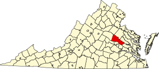
Orange County is a county located in the Central Piedmont region of the Commonwealth of Virginia. At the 2020 census, the population was 36,254. Its county seat is Orange. Orange County includes Montpelier, the 2,700-acre (1,100 ha) estate of James Madison, the 4th President of the United States and often known as the "Father of the Constitution". The county will celebrate its 290th anniversary in 2024.
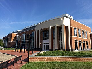
Hanover County is a county in the Commonwealth of Virginia. As of the 2020 census, the population was 109,979. Its county seat is Hanover.

Goochland County is a county located in the Piedmont of the Commonwealth of Virginia. Its southern border is formed by the James River. As of the 2020 census, the population was 24,727. Its county seat is Goochland.

East Hanover Township is a township in Dauphin County, Pennsylvania, United States. The population was 6,009 at the 2020 census.
Ashland is a town in Hanover County, Virginia, United States, located 16 miles (26 km) north of Richmond along Interstate 95 and U.S. Route 1. As of the 2020 census it had a population of 7,565, up from 7,225 at the 2010 census.
Mechanicsville is an unincorporated community and census-designated place (CDP) in Hanover County, Virginia, United States. The population was 39,482 during the 2020 census, up from 36,348 in the 2010 census.

Doswell is an unincorporated community in Hanover County in the Central Region of the U.S. Commonwealth of Virginia. Originally called Hanover Junction, it was located on the Virginia Central Railroad at a crossing of the Richmond, Fredericksburg and Potomac Railroad, a north–south route. Both railroads are now owned by CSX Transportation, although the former Virginia Central line is leased to a short-line carrier, Buckingham Branch Railroad. The area near the Doswell train station is a popular train-watching site for railfans.
Beaverdam is a small unincorporated community in Hanover County in the central region of the U.S. state of Virginia. The community was named after the beaver dams in the area.

Aldie is an unincorporated community and census-designated place (CDP) located between Chantilly and Middleburg in Loudoun County, Virginia, United States. The historic village of Aldie is located on the John Mosby Highway in a gap between the Catoctin Mountains and Bull Run Mountains, through which the Little River flows. Aldie traditionally serves as the gateway to the Loudoun Valley and beyond.

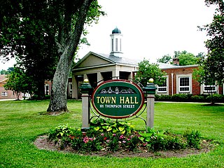
Hanover is an unincorporated community and census-designated place (CDP) in Hanover County, Virginia, United States. It is the county seat and is located at the junction of U.S. Route 301 and State Route 54 south of the Pamunkey River. While historically known as Hanover Courthouse, the U.S. Geological Survey, Census Bureau, Postal Service and residents refer to it as "Hanover". The population as of the 2010 census was 252.

Flintstone is an unincorporated community and census-designated place (CDP) in Allegany County, Maryland, United States. As of the 2010 census it had a population of 177. It is part of the Cumberland, MD-WV Metropolitan Statistical Area.

Virginville is a census-designated place in Richmond Township, Berks County, Pennsylvania, United States. It is located at the junction of PA 143 and Crystal Ridge Road, and is approximately seven miles to the south of the borough of Lenhartsville.
Maidens is a small unincorporated community in Goochland County, Virginia, United States. Sited on the north side of the James River, it is currently located at the junction of U.S. Route 522, State Route 6, and State Route 634.

This is a list of the National Register of Historic Places listings in Richmond, Virginia.
This is a list of the National Register of Historic Places listings in Hanover County, Virginia.
Montpelier is an unincorporated community in Clay County, Mississippi, United States. It is located along Mississippi Highway 46 in the northwestern part of the county. The community contains West Clay Elementary School.

Montpelier Station is an unincorporated community in Orange County, Virginia, United States. Montpelier Station is located along Virginia State Route 20 3.5 miles (5.6 km) west-southwest of Orange. Montpelier Station has a post office with ZIP code 22957.

Arneytown is an unincorporated community located along Province Line Road on the border of North Hanover Township in Burlington County and Upper Freehold Township in Monmouth County of New Jersey. It is two miles (3.2 km) north of Jacobstown. Province Line Road was on the boundary line between the Provinces of East Jersey and West Jersey. The area was once called Upper Freehold by 18th-century Quaker settlers. With the establishment of the first post office in 1827, it became known as Arneytown.
Amsterdam is an unincorporated community located within Holland Township in Hunterdon County, in the U.S. state of New Jersey. Located on the southern flank of the Musconetcong Mountain, the area was settled in the first half of the 18th century. It was later named after Amsterdam, Netherlands. The Amsterdam Historic District, encompassing the community, was listed on the state and national registers of historic places in 1995.

The Plainfield Village Historic District encompasses a significant portion of the village of Plainfield, Vermont. Located in northernmost Plainfield on United States Route 2, the village grew in the 19th century as a mill town and service community for the surround agricultural areas, and has a well-preserved collection of Greek Revival and Italianate architecture. It was listed on the National Register of Historic Places in 1983.


