
Morelos, officially the Free and Sovereign State of Morelos, is one of the 32 states which comprise the Federal Entities of Mexico. It is divided into 36 municipalities and its capital city is Cuernavaca.

Benito Juárez is one of the eleven municipalities of the Mexican state of Quintana Roo. Most of its population reside in the municipal seat, Cancún. It is named after the 19th century president and statesman Benito Juárez.
Ciudad Ayala is a city in the east-central part of the Mexican state of Morelos. It stands at 18°45′59″N98°59′05″W, at a mean height of 1,220 m (4,000 ft) above sea level. The city is named for Coronel Francisco Ayala (1760-1812) who fought with José María Morelos during the 1812 Siege of Cuautla. The town's previous name was Mapachtlan. Ayala became a municipality on April 17, 1869.
Ocuituco is a town in the Mexican state of Morelos and the municipal head for the Municipality of Ocuituco which includes the towns of Ocuituco, Huejotengo, Huecahuaxco, Huepalcalco, Metepec, and Ocoxaltepec, as well as a number of settlements with fewer than 300 inhabitants. The name comes from Nahuatl Okuiltoco and means Where there are weevils. It is one of the 36 municipalities of the state of Morelos. To the north of Ocuitico is México State, southeast is Zacualpan, east is Tetela del Volcán, and southwest is Yecapixtla. It stands at 18°52′N98°46′W, at 1,920 meters above sea level. It is considered one of the municipalities of the "Los altos de Morelos".

Tepoztlán is a town in the central Mexican state of Morelos. It is located at 18°59′07″N99°05′59″W in the heart of the Tepoztlán Valley. The town serves as the seat of government for the municipality of the same name. The town had a population of 14,130 inhabitants, while the municipality reported 41,629 inhabitants in the 2010 national census.

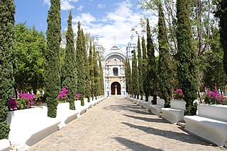
Tlayacapan is the name of a town and a municipality located in the northeast part of Morelos state in central Mexico. It is located 60 km east from the state capital of Cuernavaca and about 1.5 hours south of Mexico City. It is a rural area, whose way of life has not changed much over the 20th century, with 90% of its population still partially or fully dependent on agriculture. The town has old mansions, houses with red tile roofs and streets paved with stones. Many ravines crisscross the area and are crossed by numerous stone bridges.

Zacatepec de Hidalgo is a town in the state of Morelos, Mexico. It is bordered by Puente de Ixtla, Tlaltizapán, Tlaquiltenango and Jojutla. Miguel Hidalgo was the priest whose call to arms on September 16, 1810, led to the Mexican War of Independence.
Zacualpan de Amilpas is a town in the Mexican state of Morelos. The town serves as the municipal seat for the surrounding municipality, with which it shares a name. To the north is the municipality of Tetela del Volcán, to the south is the municipality of Temoac, to the east is the State of Puebla, and to the west are the municipalities of Ocuituco and Yecapixtla.

San Andrés Hueyapan is a small town in the rural northeastern part of the Mexican state of Morelos, formerly in the municipality of Tetela del Volcán. It lies at an elevation of ca 2000–2500 metres above sea level on the southern slopes of the active volcano Popocatépetl. To the west of Hueyapan runs the Amatzinac river, to the north is the Popocatépetl-Iztaccíhuatl natural reserve, and to the south the town of Tlacotepec and to the east is the municipality of Tochimilco which belongs to the state of Puebla located in the midlands.
Churumuco is a municipality located in the southeastern part of the Mexican state of Michoacán. The municipality has an area of 1,119.44 square kilometres and is bordered to the north by the municipality of La Huacana, to the northeast by Turicato, to the south by the state of Guerrero, to the southwest by Huetamo, and to the west by Arteaga. The municipality had a population of 13,801 inhabitants according to the 2005 census.
Ocotlán de Morelos is a town and municipality in the state of Oaxaca, about 35 km south of the center of the city of Oaxaca along Highway 175. It is part of the Ocotlán District in the south of the Valles Centrales Region. The area was a significant population center at the time of the Spanish Conquest, and for that reason an important Dominican monastery was established here in the 16th century. The complex still exists, with the church still being used for worship and the cloister area used as a museum. While mostly quiet, the city is an important distribution and transportation center for the south of the Central Valleys region of Oaxaca, a function which is expected to be reinforced with the opening of new highway being built to connect the city of Oaxaca with the Pacific coast. The city is known for artist Rodolfo Morales, who painted aspects of his hometown in his works and sponsored projects to save and restore historic monuments here. For generations the municipality has been known for its crafts, with the ceramics making Aguilar family producing some of the best known craftsmen.

Huitiupán is a town and municipality in the Mexican state of Chiapas in southern Mexico.
Federal Highway 95 connects Mexico City to Acapulco, Guerrero. The Autopista del Sol is a tolled alternative, which bypasses several towns of the state of Guerrero, including the city Iguala, and thus reduces transit time between Acapulco from Mexico city from 8 hours to almost 3.5 hours.
Pilcaya is one of the 81 municipalities of Guerrero, in south-western Mexico. The municipal seat lies at Pilcaya. The municipality covers an area of 62.1 km².
Atenango del Río is a city and seat of the municipality of Atenango del Río, in the state of Guerrero, south-western Mexico.
Pilcaya is a town and municipal seat of the Municipality of Pilcaya in the state of Guerrero, Mexico, located 153 kilometres (95 mi) from Mexico City, 105 kilometres (65 mi) from Cuernavaca, 84 kilometres (52 mi) from Toluca, 68 kilometres (42 mi) from Taxco and 5 kilometres (3 mi) from Ixtapan de la Sal. The name "Pilcaya" is from the Nahuatl word pilcacyan, place of a hanging object.
Morelos is one of 125 municipalities in the State of Mexico in Mexico. The municipal seat is the town of San Bartolo Morelos which is the fifth largest town in the municipality. The municipality covers an area of 222.76 km².
Santo Domingo de Morelos is a town and municipality in Oaxaca in south-western Mexico. The municipality covers an area of 107.17 km². It is part of the Pochutla District in the east of the Costa Region.

José María Morelos is one of the eleven municipalities that make up the Mexican state of Quintana Roo.

Morelos is a semi-urban municipality in the metropolitan area of Zacatecas City in the Mexican state of Zacatecas.

