Morin-Heights

Last updated

Morin-Heights
Morin Heights downtown.jpg
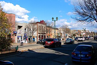
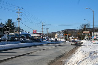
Downtown Morin-Heights
Motto: 
L'harmonie c'est dans notre nature
Morin-Heights Quebec location diagram.png
Location within Les Pays-d'en-Haut RCM.
Canada Central Quebec location map.png
Red pog.svg
Morin-Heights
Location in central Quebec.
Coordinates: 45°54′N74°15′W / 45.900°N 74.250°W / 45.900; -74.250 [1]
CountryCanada
Province Quebec
Region Laurentides
RCM Les Pays-d'en-Haut
Settled1850
ConstitutedJuly 1, 1855
Government
[2]
  MayorTimothy Watchorn
   Federal riding Argenteuil—La Petite-Nation
   Prov. riding Argenteuil
Area
  Total59.40 km2 (22.93 sq mi)
  Land55.96 km2 (21.61 sq mi)
Population
 (2021) [3]
  Total4,678
  Density83.6/km2 (217/sq mi)
  Pop (2016–21)
Increase2.svg 12.9%
  Dwellings
2,762
Time zone UTC−5 (EST)
  Summer (DST) UTC−4 (EDT)
Postal code(s)
Area code(s) 450 and 579
Website www.morinheights.com

Morin-Heights Library Morin Heights town hall.jpg
Morin-Heights Library

Morin-Heights is a town in the Laurentian Mountains region of Quebec, Canada. It is west of Saint-Sauveur and north of Lachute; municipally, it is within the Regional County Municipality of Les Pays-d'en-Haut.

Contents

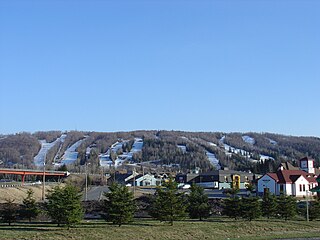
It is primarily a tourist town, having a large ski hill (Ski Morin Heights) that is popular during the winter months and being on a recreational trailway (the Aerobic Corridor), which is used year-round. A dense network of hiking, cross country skiing, snowshoeing and mountain biking trails surround Morin-Heights, making it the closest multi-recreational outdoor hub to Montreal (45-minute drive in moderate traffic). The old train station, on Lac Écho road, is the starting point for most recreational activities, year-round. The Rivière à Simon offers enjoyable canoeing and kayaking all the way down to Christieville and beyond.

Formerly located just south of the town was a recording studio, called Le Studio, built in 1975, which is now closed. The facility was used by numerous Canadian and international artists, including The Tragically Hip, Rush, Nazareth, Pilot, April Wine, Asia, Rainbow, Barenaked Ladies, Sting, The Police, The Rolling Stones, David Bowie, The Bee Gees, Cat Stevens, and Lawrence Gowan, as well as by Quebec artists Jean-Pierre Ferland, Richard Séguin, Lucien Francœur and Garolou. In 1994, another important music recording facility was built in Morin-Heights, on the northern edge of town. Conceived and built by Swedish-born artist Lars Westvind, Studio Nomade exclusively hosted Sarah McLachlan's recording projects up to 2000. It then was open to other artists, and is still a frequently used production facility. The town hosts a theatre company featuring mostly English-language plays, as well as a choir.

History

The first European settlers (the Seale brothers) arrived from Ireland around 1850, followed by French Canadians from Lachute, Saint-Jérôme and Saint-Eustache. In 1852, the Morin Township was formed and in 1855, the Township Municipality of Morin-Partie-Sud was established in a part of the township (the remaining part became Sainte-Adèle). [4]

The township was named after its founder and 19th-century politician Augustin-Norbert Morin (1803–1865) who had at that point a huge farm of more than three square kilometres (1.2 sq mi) on the banks of the Rivière du Nord, built around 1850–1860 and included a home, saw mill, and flour mill. An alternate, less accepted origin for the name Morin concerns an engineer named Morin who was dispatched by the provincial government to survey the region and had hired a Native American named Simon as guide, whose name was used to identify the river flowing through the township. [4]

Until 1911, the territory had just the names of Bas-Morin or Morin Flats, name of the post office between 1875 and 1911, while the railway station was known as Morin-Heights Station. In 1950, Morin-Partie-Sud changed its statutes and name to become the Municipality of Morin-Heights. [4]

The town gained notoriety in 1994 when members of the Order of the Solar Temple took part in a mass suicide, after setting fire to the ski chalet they occupied in the community. [5]

On March 12, 2008, a roof collapse in the Gourmet du Village bakery warehouse killed three women. An excessive accumulation of snow was suspected to be the cause of the accident. A total of 40 people were in the building at the time of the collapse. [6]

Demographics

Historical population
YearPop.±%
19911,960    
1996 2,332+19.0%
2001 2,575+10.4%
2006 3,503+36.0%
2011 3,925+12.0%
2016 4,145+5.6%
2021 4,678+12.9%
[7]

Private dwellings occupied by usual residents: 2211 (total dwellings: 2762)

Home language:

Education

Sir Wilfrid Laurier School Board operates Anglophone public schools:

Morin-Heights Library serves the community.

See also

Related Research Articles

<span class="mw-page-title-main">Saint-Sauveur, Quebec</span> City in Quebec, Canada

Saint-Sauveur is a town and municipality within the Les Pays-d'en-Haut Regional County Municipality, Quebec, Canada. It is in the administrative region of Laurentides in the Laurentian mountains, located about 60 kilometres north of Montreal.

<span class="mw-page-title-main">Brownsburg-Chatham</span> City in Quebec, Canada

Brownsburg-Chatham is a municipality in the Laurentides region of Quebec, Canada, part of the Argenteuil Regional County Municipality.

<span class="mw-page-title-main">Sainte-Anne-des-Lacs</span> Parish municipality in Quebec, Canada

Sainte-Anne-des-Lacs is a municipality in the regional county municipality of Les Pays-d'en-Haut in Quebec, Canada, located in the administrative region of Laurentides. The municipality was founded in 1946 and was assigned the municipal number 77035 by the Quebec government. The Roman Catholic parish of Sainte-Anne-des-Lacs was founded in 1940.

<span class="mw-page-title-main">Prévost, Quebec</span> City in Quebec, Canada

Prévost is a town within the La Rivière-du-Nord Regional County Municipality, Quebec, Canada, and the administrative region of Laurentides in the Laurentian Mountains, north of Montreal. It was created in 1973 from the amalgamation of the former villages of Shawbridge and Lesage with old Prévost on the other side of the Rivière du Nord. Shawbridge was named after William Shaw (1805-1894) who settled in the township of Abercromby in 1847 and built the first bridge over the Rivière du Nord.

<span class="mw-page-title-main">Piedmont, Quebec</span> Municipality in Quebec, Canada

Piedmont is a small municipality within the Les Pays-d'en-Haut Regional County Municipality, Quebec, Canada, in the Laurentian Mountains of the administrative region of Laurentides. It is located along the North River and Autoroute 15 and Route 117, north of Montreal.

<span class="mw-page-title-main">Saint-Adolphe-d'Howard</span> Municipality in Quebec, Canada

Sainte-Agathe-des-Monts

<span class="mw-page-title-main">Gore, Quebec</span> Township municipality in Quebec, Canada

Gore is a township municipality in the Canadian province of Quebec, located within the Argenteuil Regional County Municipality. Its main community is Lakefield.

<span class="mw-page-title-main">Harrington, Quebec</span> Township municipality in Quebec, Canada

Harrington is a township municipality in the Laurentides region of Quebec, Canada, part of the Argenteuil Regional County Municipality. It is located in the Laurentian Mountains, about 40 kilometres (25 mi) north-west of Lachute.

<span class="mw-page-title-main">Wentworth, Quebec</span> Township municipality in Quebec, Canada

Wentworth is a township municipality in the Laurentides region of Quebec, Canada, part of the Argenteuil Regional County Municipality, north-west of Lachute.

<span class="mw-page-title-main">Montcalm, Quebec</span> Municipality in Quebec, Canada

Montcalm is a municipality in the Les Laurentides Regional County Municipality of Quebec southeast of Mont-Tremblant. The main population centre in Montcalm is the village of Weir.

<span class="mw-page-title-main">Chénéville, Quebec</span> Municipality in Quebec, Canada

Chénéville is a town and municipality in the Outaouais region of Quebec, Canada, part of the Papineau Regional County Municipality.

<span class="mw-page-title-main">Namur, Quebec</span> Municipality in Quebec, Canada

Namur is a town and municipality in the Outaouais region of Quebec, Canada, part of the Papineau Regional County Municipality. It is nicknamed "la Nouvelle Belgique".

<span class="mw-page-title-main">Saint-Émile-de-Suffolk, Quebec</span> Municipality in Quebec, Canada

Saint-Émile-de-Suffolk is a municipality in the Outaouais region of Quebec, Canada, part of the Papineau Regional County Municipality. Until 1994 it was known as United Township Municipality of Suffolk-et-Addington.

<span class="mw-page-title-main">Boileau, Quebec</span> Municipality in Quebec, Canada

Boileau is a village and municipality in the Outaouais region of Quebec, Canada, part of the Papineau Regional County Municipality. The municipality was known as Ponsonby until 1993.

<span class="mw-page-title-main">Saint-Colomban, Quebec</span> City in Quebec, Canada

Saint-Colomban is a city in the regional county municipality of La Rivière-du-Nord in Québec, Canada. It is situated in the Laurentides region of Québec and was named in honour of Saint Columbanus.

<span class="mw-page-title-main">Saint-André-d'Argenteuil</span> Municipality in Quebec, Canada

Saint-André-d'Argenteuil is a municipality in the Laurentides region of Quebec, Canada, part of the Argenteuil Regional County Municipality. It is located along the Ottawa River, just south of Lachute.

<span class="mw-page-title-main">Mille-Isles</span> Municipality in Quebec, Canada

Mille-Isles is a municipality in the Laurentides region of Quebec, Canada, part of the Argenteuil Regional County Municipality, west of Saint-Jérôme.

<span class="mw-page-title-main">Wentworth-Nord</span> Municipality in Quebec, Canada

Wentworth-Nord is a municipality in the Laurentides region of Quebec, Canada, part of the Les Pays-d'en-Haut Regional County Municipality.

<span class="mw-page-title-main">Lac-des-Seize-Îles</span> Municipality in Quebec, Canada

Lac-des-Seize-Îles is a village and municipality in the Laurentides region of Quebec, Canada, part of the Les Pays-d'en-Haut Regional County Municipality. The municipality surrounds and is named after Sixteen Island Lake with the village situated at the northern end of this lake.

<span class="mw-page-title-main">Val-Morin</span> Municipality in Quebec, Canada

Val-Morin is a municipality in the Laurentides region of Quebec, Canada, part of the Les Laurentides Regional County Municipality.

References

  1. "Banque de noms de lieux du Québec: Reference number 42534". toponymie.gouv.qc.ca (in French). Commission de toponymie du Québec.
  2. 1 2 "Répertoire des municipalités: Geographic code 77050". www.mamh.gouv.qc.ca (in French). Ministère des Affaires municipales et de l'Habitation.
  3. 1 2 "Profile table, Census Profile, 2021 Census of Population - Morin-Heights, Municipalité (MÉ) [Census subdivision], Quebec". 9 February 2022.
  4. 1 2 3 "Morin-Heights (Municipalité)" (in French). Commission de toponymie du Québec. Archived from the original on 1 February 2016. Retrieved 16 March 2009.
  5. Montgomery, Marc (4 October 2018). "History Canada: October 4,1994: An international cult tragedy begins". Radio Canada International . Retrieved 7 February 2021.
  6. "Co-workers pay tribute to roof collapse victims". CTV News . 13 March 2008. Retrieved 13 March 2008.
  7. Statistics Canada: 1996, 2001, 2006, 2011, 2016, 2021 census
  8. "MORIN HEIGHTS ELEMENTARY ZONE." Sir Wilfrid Laurier School Board. Retrieved on 16 September 2017.
  9. "LAURENTIAN REGIONAL HS ZONE." Sir Wilfrid Laurier School Board. Retrieved on 4 September 2017.