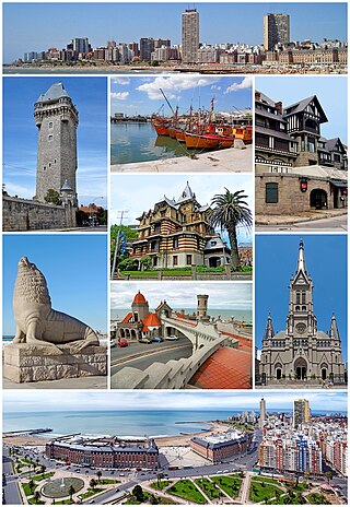
Mar del Plata is a city on the coast of the Atlantic Ocean, in Buenos Aires Province, Argentina. It is the seat of General Pueyrredón district. Mar del Plata is the second largest city in Buenos Aires Province. The name "Mar del Plata" is a shortening of "Mar del Rio de la Plata," and has the meaning of "sea of the Rio de la Plata basin" or "adjoining sea to the (River) Plate region". Mar del Plata is one of the major fishing ports and the biggest seaside beach resort in Argentina. With a population of 682,605 as per the 2022 census [INDEC], it is the 5th largest city in Argentina.

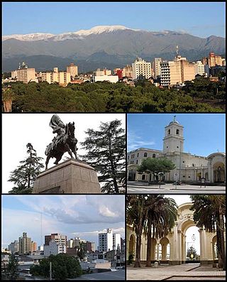
Salta is the capital and largest city in the Argentine province of the same name. With a population of 618,375 according to the 2010 census, it is also the 7th most-populous city in Argentina. The city serves as the cultural and economic center of the Valle de Lerma Metropolitan Area, which is home to over 50.9% of the population of Salta Province and also includes the municipalities of La Caldera, Vaqueros, Campo Quijano, Rosario de Lerma, Cerrillos, La Merced and San Lorenzo. Salta is the seat of the Capital Department, the most populous department in the province.
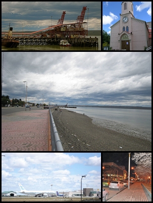
Río Gallegos is the capital and largest settlement of the Patagonian province of Santa Cruz in Argentina. Located in the department of Güer Aike, it has a population of about 98,000, according to the 2010 census [INDEC], a 24% increase from the 79,000 in the 2001 census [INDEC]. The city bears the name of the Gallegos River, and sits on its estuary 2,636 km (1,638 mi) south from the Argentine federal capital Buenos Aires.
San Salvador de Jujuy, commonly known as Jujuy and locally often referred to as San Salvador, is the capital and largest city of Jujuy Province in northwest Argentina. Also, it is the seat of the Doctor Manuel Belgrano Department. It lies near the southern end of the Humahuaca Canyon where wooded hills meet the lowlands.

Río Grande is a city in Argentina, on the north coast of the eastern part of the Isla Grande de Tierra del Fuego. It has a population of 98,017, and is the industrial capital of the Tierra del Fuego Province. It is located 212 kilometres (132 mi) north-east of Ushuaia, the capital of the province.

Ponferrada is a city of Spain, located in the autonomous community of Castile and León. Ponferrada, the second most populated municipality of the Province of León, is also the capital city of El Bierzo, the only comarca recognized as an administrative entity by law in the region.

Esperanza Base is a permanent, all-year-round Argentine research station in Hope Bay, Trinity Peninsula. It is one of only two civilian settlements in Antarctica. The base's motto is Permanencia, un acto de sacrificio.

Lages is a Brazilian municipality located in the central part of the state of Santa Catarina, in the region known in Portuguese as "Planalto Serrano".

Paysandú is an Uruguayan city and the capital of Paysandú Department in western Uruguay.

Junín is a city in the province of Buenos Aires, Argentina, and administrative seat of the partido of Junín. It has a population of 85,420 and is located 260 km (162 mi) west of the city of Buenos Aires. It is mostly known for being the hometown of former first lady of Argentina Eva Perón.

Puerto Iguazú is a border city in the province of Misiones, Argentina. With a population of 82,227 , it is the fourth largest city in the Province, after Posadas, Oberá, and Eldorado.

Parintins is a municipality in the far east of the Amazonas state of Brazil. It is part of a microregion also named Parintins. The population for the entire municipality was 115,363 and its area is 5,952 km2. The city is located on Tupinambarana island in the Amazon River. Parintins is known for the Parintins Folklore Festival, a popular festival held there each June and depicting Boi-Bumbá. It was also the site of an experimental deployment of WiMAX, sponsored by Intel, in late 2006.

Ramos Arizpe is a city and seat of the surrounding municipality of the same name in the Mexican state of Coahuila. Ramos Arizpe is located 11 km from the state capital of Saltillo. It is part of the Saltillo metropolitan area. The city reported a population of 48,228 in the 2005 census; the municipality had a population of 56,708. Its area is 5,306.6 km2.
Saint-Maurice is a commune in the southeastern suburbs of Paris, France. It is located 6.8 km (4.2 mi) from the center of Paris. The insane asylum Charenton was located in Saint-Maurice; it is now a psychiatric hospital.
La Quiaca is a small city in the north of the province of Jujuy, Argentina, on the southern bank of the La Quiaca River, opposite the town of Villazón, Bolivia. It lies at the end of National Route 9, 289 km (180 mi) from San Salvador de Jujuy, and at an altitude of 3,442 m (11,293 ft) above mean sea level.

El Calafate, also known as Calafate, is a city in Patagonia, Argentina. It is situated on the southern border of Lake Argentino, in the southwest part of the Santa Cruz Province, about 320 kilometres (200 mi) northwest of Río Gallegos. The name of the city is derived from a little bush with yellow flowers and dark blue berries that is very common in Patagonia: the calafate ; the word comes from the word calafate, which is Spanish for 'caulk'.

The climate in Brazil varies considerably from mostly tropical north to temperate zones south of the Tropic of Capricorn. For further information on the latter, please see the Climate of South Brazil and Climate of Southeast Brazil pages.

Almost all of Uruguay has a humid subtropical climate. It is fairly uniform nationwide, since the country is located entirely within the temperate zone. Seasonal variations do exist, but extremes in temperature are rare. As would be expected by its abundance of water, high humidity and fog are common. The absence of mountains and other weather barriers makes all locations vulnerable to high winds and rapid changes in weather as fronts or storms sweep across the country. Weather is sometimes humid.

Huejutla de Reyes is a city and one of the 84 municipalities of Hidalgo, in central-eastern Mexico. The name comes from the Nahuatl huexotl ("willow") and tlan ("place"), while "de Reyes" commemorates local cobbler Antonio Reyes Cabrera who died defending Huejutla from French invaders in 1866.
Bom Jesus is a municipality in the state of Piauí in the Northeast region of Brazil.