Morombe

Last updated
Morombe
Didierea Andombiry Morombe Madagascar - panoramio.jpg
a Didierea in Andombiry, Morombe
Madagascar location map.svg
Red pog.svg
Morombe
Location in Madagascar
Coordinates: 21°45′S43°22′E / 21.750°S 43.367°E / -21.750; 43.367
CountryFlag of Madagascar.svg  Madagascar
Region Atsimo-Andrefana
District Morombe
Government
[1]
  MayorAdolphe Faralahy
Elevation
7 m (23 ft)
Population
 (2018)Census
  Total22,625
  Ethnicities
Vezo
Time zone UTC3 (EAT)
Postal code
618

Morombe is an urban municipality (commune urbaine) on the south-west coast in Atsimo-Andrefana, Madagascar. It can be reached by the National road 55 or pirogue from Morondava. It is situated at 283 km from Tulear. [2]

Contents

An airport serves the town.

Television

For 17 years now there is no television available in Morombe. At the time the transmitter broke down, the director took it to Tulear and later to Antananarivo but it was never returned. [3]

Baobab d'Andombiro

Three Brothers Baobab in Andombiry, Morombe Three Brothers Baobab Andombiry Morombe Madagascar - panoramio.jpg
Three Brothers Baobab in Andombiry, Morombe

The largest baobab in this world is found in the village of Belintsaka, 23 kilometres or 14 miles from Morombe. It has a circumference of almost 28 metres or 92 feet. There are more than 6000 adult baobabs alone in the forest of Andombiry of which 30 specimen are very large, with a circumference of more than 20 metres or 66 feet. [4]

Climate

Morombe has a hot semi-arid climate (Köppen BSh) with a short and highly variable [5] wet season in January and February. These two months account for about 70 percent of an annual rainfall that averages around 450 millimetres or 18 inches, although during the 2000 floods that amount fell in just 36 hours. [6]

Climate data for Morombe (1991–2020)
MonthJanFebMarAprMayJunJulAugSepOctNovDecYear
Record high °C (°F)35.6
(96.1)
35.8
(96.4)
34.9
(94.8)
34.9
(94.8)
34.5
(94.1)
34.1
(93.4)
33.3
(91.9)
34.9
(94.8)
35.8
(96.4)
35.8
(96.4)
35.7
(96.3)
35.8
(96.4)
35.8
(96.4)
Mean daily maximum °C (°F)30.7
(87.3)
30.7
(87.3)
31.0
(87.8)
30.4
(86.7)
29.0
(84.2)
28.0
(82.4)
27.3
(81.1)
27.6
(81.7)
28.6
(83.5)
29.6
(85.3)
30.0
(86.0)
30.4
(86.7)
29.4
(84.9)
Daily mean °C (°F)27.9
(82.2)
27.8
(82.0)
27.8
(82.0)
26.6
(79.9)
24.7
(76.5)
23.2
(73.8)
22.4
(72.3)
23.2
(73.8)
24.3
(75.7)
25.7
(78.3)
26.9
(80.4)
27.7
(81.9)
25.7
(78.3)
Mean daily minimum °C (°F)25.0
(77.0)
24.8
(76.6)
24.5
(76.1)
22.7
(72.9)
20.4
(68.7)
18.3
(64.9)
17.5
(63.5)
18.7
(65.7)
19.9
(67.8)
21.8
(71.2)
23.7
(74.7)
24.8
(76.6)
21.8
(71.2)
Record low °C (°F)18.2
(64.8)
17.2
(63.0)
16.2
(61.2)
14.5
(58.1)
12.4
(54.3)
10.0
(50.0)
7.9
(46.2)
10.0
(50.0)
10.6
(51.1)
13.4
(56.1)
14.7
(58.5)
17.0
(62.6)
7.9
(46.2)
Average precipitation mm (inches)207.4
(8.17)
118.7
(4.67)
47.6
(1.87)
13.0
(0.51)
3.3
(0.13)
3.0
(0.12)
1.9
(0.07)
1.9
(0.07)
4.1
(0.16)
5.5
(0.22)
14.7
(0.58)
29.5
(1.16)
450.6
(17.74)
Average precipitation days (≥ 1.0 mm)8.36.13.01.10.60.50.30.30.40.50.72.924.7
Source: NOAA [7]

See also

Related Research Articles

<span class="mw-page-title-main">Geography of Nigeria</span> Overview of the geography of Nigeria

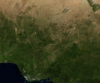
Nigeria is a country in West Africa. It shares land borders with the Republic of Benin to the west, Chad and Cameroon to the east, and Niger to the north. Its coast lies on the Gulf of Guinea in the south and it borders Lake Chad to the northeast. Notable geographical features in Nigeria include the Adamawa Plateau, Mambilla Plateau, Jos Plateau, Obudu Plateau, the Niger River, Benue River, and Niger Delta.

<span class="mw-page-title-main">Geography of Madagascar</span>

Madagascar is a large island in the Indian Ocean off the eastern coast of Southern Africa, east of Mozambique. It has a total area of 587,040 square kilometres (226,660 sq mi) with 581,540 square kilometres (224,530 sq mi) of land and 6,900 square kilometres (2,700 sq mi) of water. Madagascar is the fourth-largest island and the second-largest island country in the world. The highest point is Maromokotro, in the Tsaratanana Massif region in the north of the island, at 2,876 metres (9,436 ft). The capital Antananarivo is in the Central Highlands near the centre of the island. It has the 25th largest exclusive economic zone of 1,225,259 km2 (473,075 sq mi). Madagascar is 400 kilometres east of mainland Africa.

<span class="mw-page-title-main">Mahajanga</span> City and district in Boeny, Madagascar

Mahajanga is a city and an administrative district on the northwest coast of Madagascar. The city of Mahajanga is the capital of the Boeny Region. The district had a population of 258,068 in 2020.

<span class="mw-page-title-main">Toliara</span> Place in Atsimo-Andrefana, Madagascar

Toliara is a city in Madagascar.

<span class="mw-page-title-main">Fianarantsoa</span> Place in Haute Matsiatra, Madagascar

Fianarantsoa is a city in south central Madagascar, and is the capital of Haute Matsiatra Region.

<span class="mw-page-title-main">Morondava</span> City in Menabe, Madagascar

Morondava is a city located in Menabe Region, of which it is the capital, in Madagascar. It is located in the delta of the Morondava River at 20°17′5″S44°19′3″E. Its population as of the 2018 census, was 53,510.

<span class="mw-page-title-main">Farafangana</span> City in Atsimo-Atsinanana, Madagascar

Farafangana is a city on the south-east coast of Madagascar and capital of the Atsimo-Atsinanana region.

<span class="mw-page-title-main">Antsohihy</span> Commune urbaine in Sofia, Madagascar

Antsohihy is a city in northern Madagascar. It is the administrative capital of the Sofia Region.

<span class="mw-page-title-main">Ambalavao</span> Place in Haute Matsiatra, Madagascar

Ambalavao is a city in Madagascar, in the Haute Matsiatra region. The city is in the most southern part of the Central Highlands, near the city of Fianarantsoa.

<span class="mw-page-title-main">Menabe</span> Region in Madagascar

Menabe is a region in western Madagascar, with its capital at Morondava. It covers an area of 46,121 square kilometres, and its population was 700,577 in 2018. The population mostly belongs to the Sakalava ethnic group. The region is named after the 18th-century Sakalava Kingdom of Menabe. The name "Menabe", in turn, means "big red", after the color of laterite rock that dominates the landscape.

<i>Adansonia grandidieri</i> Species of tree from Madagascar

Adansonia grandidieri is the biggest and most famous of Madagascar's six species of baobabs. It is sometimes known as Grandidier's baobab or the giant baobab. In French it is called Baobab malgache. The local name is renala or reniala. This tree is endemic to the island of Madagascar, where it is an endangered species threatened by the encroachment of agricultural land. This is the tree found at the Avenue of the Baobabs.

<i>Adansonia za</i> Species of flowering plant

Adansonia za is a species of baobab in the genus Adansonia of the family Malvaceae. It was originally named in French as anadzahé. Common names in Malagasy include bojy, boringy, bozy, bozybe, ringy, and za, the last of which gives the plant its specific epithet. Eight Adansonia species are recognized, with six endemic to Madagascar. Adansonia za is the most widespread of the Madagascar endemics.

<span class="mw-page-title-main">Avenue of the Baobabs</span> Protected area in Madagascar

The Avenue of the Baobabs, or Alley of the Baobabs, is a prominent group of Grandidier's baobabs lining the unpaved Road No.8 between Morondava and Belon'i Tsiribihina in the Menabe region of western Madagascar. Its striking landscape draws travelers from around the world, making it one of the most visited locations in the region. It has been a center of local conservation efforts, and was granted temporary protected status in July 2007 by the Ministry of Environment, Water and Forestry – a step toward making it Madagascar's first natural monument.

<span class="mw-page-title-main">Ranohira</span> Place in Ihorombe, Madagascar

Ranohira is a town and commune in Madagascar. It belongs to the district of Ihosy, which is a part of Ihorombe Region. The population of the commune was 16,041 in 2018. The nearest towns are Ilakaka at 26 km and Ihosy 93 km distance.

<span class="mw-page-title-main">Andranomena Special Reserve</span> Nature reserve in Madagascar

Andranomena Special Reserve is a wildlife reserve in Menabe Region, western Madagascar, near the city of Morondava and the rural commune of Bemanonga.

<span class="mw-page-title-main">Morondava District</span> District in Menabe, Madagascar

Morondava District is a district in the Menabe region in eastern Madagascar. Its capital is Morondava. The district has an area of 5,691 km2 (2,197 sq mi), and the estimated population in 2020 was 157,596.

<span class="mw-page-title-main">Mahanoro</span> Place in Atsinanana, Madagascar

Mahanoro is a rural municipality located in the Atsinanana region of eastern Madagascar, along the coast.

<span class="mw-page-title-main">Kirindy Forest</span> Nature reserve in Madagascar

The Kirindy Forest is a private nature reserve situated in western Madagascar, about 50 km northeast of the town of Morondava, near Ambivy. The forest reserve falls within the boundaries of the Kirindy Mitea National Park, which spreads further to the south.

<span class="mw-page-title-main">Morombe (district)</span> Place in Atsimo-Andrefana, Madagascar

Morombe is a district of Atsimo-Andrefana in Madagascar. It can be reached by the National road 55 or pirogue from Morondava. It is situated at 283 km from Tulear. The district has an area of 7,784 km2 (3,005 sq mi), and the estimated population in 2020 was 231,431.

References

  1. L'expreese de Madagascar: La ville de Morombe en délabrement avancé
  2. Contextualisation sociale et Energie renouvelable, cas de la commune urbaine de Morombe
  3. Communication: Morombe prié de RNM depuis 17 ans
  4. Monumental Trees.com
  5. Dewar, Robert E.; Wallis, James R. (December 1, 1999). "Geographical Patterning of Interannual Rainfall Variability in the Tropics and Near Tropics: An L-Moments Approach". Journal of Climate. 12 (12): 3457–3466.
  6. FAO/WFP Mission to Assess the Impact of Cyclones and Drought on the Food Supply Situation in Madagascar (Report). Food and Agriculture Organization. 2000-06-01. Retrieved 2014-08-20.
  7. "Morombe Climate Normals 1991–2020". World Meteorological Organization Climatological Standard Normals (1991–2020). National Oceanic and Atmospheric Administration. Archived from the original on 25 September 2023. Retrieved 25 September 2023.