Antongo Vaovao is a town and commune in Madagascar. It belongs to the district of Morombe, which is a part of Atsimo-Andrefana Region. The population of the commune was estimated to be approximately 7,000 in 2001 commune census.[2]
Madagascar, officially the Republic of Madagascar, and previously known as the Malagasy Republic, is an island country in the Indian Ocean, approximately 400 kilometres off the coast of East Africa. The nation comprises the island of Madagascar and numerous smaller peripheral islands. Following the prehistoric breakup of the supercontinent Gondwana, Madagascar split from the Indian subcontinent around 88 million years ago, allowing native plants and animals to evolve in relative isolation. Consequently, Madagascar is a biodiversity hotspot; over 90% of its wildlife is found nowhere else on Earth. The island's diverse ecosystems and unique wildlife are threatened by the encroachment of the rapidly growing human population and other environmental threats.
Districts are second-level administrative divisions of Madagascar below the regions. There are 114 districts in Madagascar. Districts are in their turn divided into communes; while some of the districts in urban areas and offshore islands each consist of only one commune, most of the districts are divided typically into 5–20 communes.
A census is the procedure of systematically acquiring and recording information about the members of a given population. The term is used mostly in connection with national population and housing censuses; other common censuses include agriculture, business, and traffic censuses. The United Nations defines the essential features of population and housing censuses as "individual enumeration, universality within a defined territory, simultaneity and defined periodicity", and recommends that population censuses be taken at least every 10 years. United Nations recommendations also cover census topics to be collected, official definitions, classifications and other useful information to co-ordinate international practice.
Only primary schooling is available. The majority 70% of the population of the commune are farmers, while an additional 10% receives their livelihood from raising livestock. The most important crop is lima beans, while other important products are maize, sweet potatoes and cowpeas. Services provide employment for 5% of the population. Additionally fishing employs 15% of the population.[2]
Maize, also known as corn, is a cereal grain first domesticated by indigenous peoples in southern Mexico about 10,000 years ago. The leafy stalk of the plant produces pollen inflorescences and separate ovuliferous inflorescences called ears that yield kernels or seeds, which are fruits.
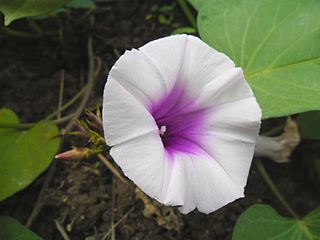
The sweet potato is a dicotyledonous plant that belongs to the bindweed or morning glory family, Convolvulaceae. Its large, starchy, sweet-tasting, tuberous roots are a root vegetable. The young leaves and shoots are sometimes eaten as greens. The sweet potato is only distantly related to the potato and does not belong to the nightshade family, Solanaceae, but both families belong to the same taxonomic order, the Solanales.
The cowpea is an annual herbaceous legume from the genus Vigna. Due to its tolerance for sandy soil and low rainfall it is an important crop in the semi-arid regions across Africa and other countries. It requires very few inputs, as the plant's root nodules are able to fix atmospheric nitrogen, making it a valuable crop for resource-poor farmers and well-suited to intercropping with other crops. The whole plant is used as forage for animals, with its use as cattle feed likely responsible for its name.
A geographic coordinate system is a coordinate system that enables every location on Earth to be specified by a set of numbers, letters or symbols. The coordinates are often chosen such that one of the numbers represents a vertical position and two or three of the numbers represent a horizontal position; alternatively, a geographic position may be expressed in a combined three-dimensional Cartesian vector. A common choice of coordinates is latitude, longitude and elevation. To specify a location on a plane requires a map projection.
This page is based on this Wikipedia article Text is available under the CC BY-SA 4.0 license; additional terms may apply. Images, videos and audio are available under their respective licenses.
Related Research Articles
Milanoa is a town and commune in northern Madagascar. It belongs to the district of Vohemar, which is a part of Sava Region. The population of the commune was estimated to be approximately 17,000 in 2001 commune census.
Andreba is a town and commune in Madagascar. It belongs to the district of Antsohihy, which is a part of Sofia Region. The population of the commune was estimated to be approximately 13,000 in 2001 commune census. It on the shore of Lake Alaotra.
Tsarahasina is a town and commune in Madagascar. It belongs to the district of Boriziny, which is a part of Sofia Region. The population of the commune was estimated to be approximately 14,000 in 2001 commune census.
Ambalakida is a town and commune in Madagascar. It belongs to the district of Mahajanga II, which is a part of Boeny Region. The population of the commune was estimated to be approximately 5,000 in 2001 commune census.
Andilamena is a town and commune in Madagascar. It belongs to the district of Andilamena, which is a part of Alaotra-Mangoro Region. The population of the commune was estimated to be approximately 21,000 in 2001 commune census.
Imerimandroso is a town and commune in Madagascar. It belongs to the district of Ambatondrazaka, which is a part of Alaotra-Mangoro Region. The population of the commune was estimated to be approximately 11,000 in 2001 commune census.
Tsimafana is a town and commune in Madagascar. It belongs to the district of Belo sur Tsiribihina, which is a part of Menabe Region. The population of the commune was estimated to be approximately 9,000 in 2001 commune census.
Andranomangatsiaka is a town and commune in southwest Madagascar. It belongs to the district of Betioky Sud, which is a part of Atsimo-Andrefana Region. The population of the commune was estimated to be approximately 10,000 in 2001 commune census.
Beavoha is a town and commune in southwest Madagascar. It belongs to the district of Betioky, which is a part of Atsimo-Andrefana Region. The population of the commune was estimated to be approximately 8,000 in 2001 commune census.
Milenaka is a town and commune in Madagascar. It belongs to the district of Toliara II, which is a part of Atsimo-Andrefana Region. The population of the commune was estimated to be approximately 15,000 in 2001 commune census.
Soalara is a town and commune in Madagascar. It belongs to the district of Toliara II, which is a part of Atsimo-Andrefana Region. The population of the commune was estimated to be approximately 10,000 in 2001 commune census.
Tsianisiha is a town and commune in Madagascar. It belongs to the district of Toliara II, which is a part of Atsimo-Andrefana Region. The population of the commune was estimated to be approximately 18,000 in 2001 commune census.
Antsampandrano is a town and commune in Madagascar. It belongs to the district of Ambatolampy, which is a part of Vakinankaratra Region. The population of the commune was estimated to be approximately 20,000 in 2001 commune census.
Ampary is a town and commune in Madagascar. It belongs to the district of Soavinandriana, which is a part of Itasy Region. The population of the commune was estimated to be approximately 9,000 in 2001 commune census.
Ambahikily is a town and commune in Madagascar. It belongs to the district of Morombe, which is a part of Atsimo-Andrefana Region. The population of the commune was estimated to be approximately 35,000 in 2001 commune census.
Mahasoabe is a town and commune in Madagascar. It belongs to the district of Fianarantsoa II, which is a part of Haute Matsiatra Region. The population of the commune was estimated to be approximately 34,000 in 2001 commune census.
Marotoko is a town and commune in Madagascar. It belongs to the district of Ifanadiana, which is a part of Vatovavy-Fitovinany Region. The population of the commune was estimated to be approximately 7,000 in 2001 commune census.
Masianaka is a town and commune in Madagascar. It belongs to the district of Vangaindrano, which is a part of Atsimo-Atsinanana Region. The population of the commune was estimated to be approximately 18,000 in 2001 commune census.
Itremo is a town and commune in Madagascar. It belongs to the district of Ambatofinandrahana, which is a part of Amoron'i Mania Region. The population of the commune was estimated to be approximately 7,000 in 2001 commune census.
Ankazoambo is a town and commune in Madagascar. It belongs to the district of Ambositra, which is a part of Amoron'i Mania Region. The population of the commune was estimated to be approximately 6,000 in 2001 commune census.