
South English is a city in Keokuk County, Iowa, United States. The population was 212 at the 2010 census. It is named for the English River.

Waldo is a village in Waldo Township, Marion County, Ohio, United States. The population was 338 at the 2010 census. Waldo is part of the River Valley Local School District.

Normandy is a town in Bedford County, Tennessee, United States. The population was 141 at the 2010 census. Normandy Dam is located just northeast of the town. The town is listed on the National Register of Historic Places as the Normandy Historic District.

Santa Maria is a census-designated place (CDP) in Cameron County, Texas, United States. The population was 733 at the 2010 census, down from 846 at the 2000 census. It is part of the Brownsville–Harlingen Metropolitan Statistical Area.
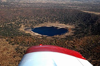
Tswaing is an impact crater in South Africa that is accompanied by a museum. It is situated 40 km to the north-west of Pretoria. This astrobleme is 1.13 km in diameter and 100 m deep and the age is estimated to be 220,000 ± 52,000 years (Pleistocene). The impactor is believed to have been a chondrite or stony meteorite some 30 to 50 m in diameter that was vapourised during the impact event. Morokweng crater, another crater of chondrite origin, lies north-west of Vryburg.

Abaeté is a municipality in the north of the Brazilian state of Minas Gerais. In 2020 the population was 23,250 in a total area of 1,816 km². It became a municipality in 1870.

Ambanja[amˈbandzə̥] is a city and commune in northern Madagascar. According to 2001 census the population of Ambanja was 28,468.

Onilahy is a river in Atsimo-Andrefana and Anosy, southern Madagascar. It flows down from the hills near Betroka to the Mozambique Channel. It empties at St. Augustin, and into the Bay of Saint-Augustin.
Bukit Minyak is an industrial zone in Central Seberang Perai District, Penang, Malaysia.

Kanclerzowice is a village in the administrative district of Gmina Żmigród, within Trzebnica County, Lower Silesian Voivodeship, in south-western Poland. Prior to 1945 it was in Germany.
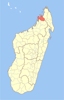
Ambanja is a district in northern Madagascar. It is a part of Diana Region and borders the districts of Ambilobe to the east, Bealanana to the south and Analalava to the south-west. The area is 5,999.72 km2 (2,317 sq mi) and the population was estimated at 190,435 in 2013. The district is further divided into 18 communes.
Ehara is a town and commune in Madagascar. It belongs to the district of Benenitra, which is a part of Atsimo-Andrefana Region. The population of the commune was estimated to be approximately 5,000 in 2001 commune census.
Wasylów Wielki is a village in the administrative district of Gmina Ulhówek, within Tomaszów Lubelski County, Lublin Voivodeship, in eastern Poland, close to the border with Ukraine. It lies approximately 8 kilometres (5 mi) east of Ulhówek, 34 km (21 mi) east of Tomaszów Lubelski, and 129 km (80 mi) south-east of the regional capital Lublin.
Węchadłów is a village in the administrative district of Gmina Michałów, within Pińczów County, Świętokrzyskie Voivodeship, in south-central Poland. It lies approximately 8 kilometres (5 mi) south-west of Michałów, 14 km (9 mi) south-west of Pińczów, and 51 km (32 mi) south of the regional capital Kielce.
Kwietniewo is a village in the administrative district of Gmina Rychliki, within Elbląg County, Warmian-Masurian Voivodeship, in northern Poland. It lies approximately 6 kilometres (4 mi) west of Rychliki, 14 km (9 mi) south of Elbląg, and 72 km (45 mi) west of the regional capital Olsztyn.

Whitelaw is a hamlet in northern Alberta, Canada within the Municipal District of Fairview No. 136. It is located 2 kilometres (1.2 mi) north of Highway 2, approximately 114 kilometres (71 mi) northeast of Grande Prairie.
Porta Lodovica was a city gate of the Spanish walls of Milan, Italy, named after Ludovico Sforza. Today, the name refers to the district (quartiere) of Milan where the gate used to be, which is part of the Zone 5 administrative division. The gate was demolished at the end of the 19th century. Plans were made to rebuild it inside the Parco di Monza city park in Monza, but they were not implemented.
Chahal Konar is a village in Tashan-e Gharbi Rural District, Tashan District, Behbahan County, Khuzestan Province, Iran. At the 2006 census, its population was 220, in 50 families.
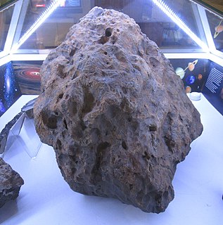
The Chelyabinsk meteorite is the fragmented remains of the large Chelyabinsk meteor of 15 February 2013 which reached the ground after the meteor's passage through the atmosphere. The descent of the meteor, visible as a brilliant superbolide in the morning sky, caused a series of shock waves that shattered windows, damaged approximately 7,200 buildings and left 1,500 people injured. The resulting fragments were scattered over a wide area.
Benenitra is a district of Atsimo-Andrefana in Madagascar.

