Mossautal

Last updated
Mossautal
Wappen Mossautal.svg
Location of Mossautal within Odenwaldkreis district
Mossautal in ERB.svgReichelsheim
Germany adm location map.svg
Red pog.svg
Mossautal
Hesse location map.svg
Red pog.svg
Mossautal
Coordinates: 49°40′29″N08°55′30″E / 49.67472°N 8.92500°E / 49.67472; 8.92500 Coordinates: 49°40′29″N08°55′30″E / 49.67472°N 8.92500°E / 49.67472; 8.92500
Country Germany
State Hesse
Admin. region Darmstadt
District Odenwaldkreis
Subdivisions5 Ortsteile
Government
   Mayor (201925) Dietmar Bareis [1] (Ind.)
Area
  Total48.5 km2 (18.7 sq mi)
Elevation
327 m (1,073 ft)
Population
 (2020-12-31) [2]
  Total2,429
  Density50/km2 (130/sq mi)
Time zone UTC+01:00 (CET)
  Summer (DST) UTC+02:00 (CEST)
Postal codes
64756
Dialling codes 06062, 06061
Vehicle registration ERB
Website www.mossautal.de

Mossautal in the Odenwald is a municipality and a state-recognized health resort in the Odenwaldkreis (district) in Hesse, Germany.

Contents

Geography

Location

The community lies at elevations of between 300 and 500 m above sea level.

The Nibelungenstraße ( Bundesstraße 47) touches Mossautal in the north and the Siegfriedstraße (Bundesstraße 460) runs through the community in the south. The surrounding countryside is also used as a holiday destination in the UNESCO Geo-Naturpark Bergstraße-Odenwald on the Marbach Reservoir, the Odenwald's biggest body of standing water.

Mossautal is well known as a textbook example of a Waldhufendorf ("forest village").

Neighbouring communities

Mossautal borders in the north on the community of Reichelsheim and the town of Michelstadt, in the east on the town of Erbach, in the south on the town of Beerfelden (all in the Odenwaldkreis), and in the west on the communities of Wald-Michelbach, Grasellenbach and Fürth (all three in the Bergstraße district).

Constituent communities

Mossautal's Ortsteile are Güttersbach, Hiltersklingen, Hüttenthal, Ober-Mossau and Unter-Mossau (the community's administrative seat).

Politics

Municipal council

Composition of the municipal council
Parties and voter communitiesSeats
2006
Seats
2016
CDU Christian Democratic Union of Germany 43
SPD Social Democratic Party of Germany 43
ÜWGÜberparteiliche Wählergemeinschaft Mossautal79
Total1515
Voter turnout in %58.557.0

Mayor

At the mayoral election on 25 April 2004, the independent Willi Keil, who had been in the mayor's office since 1986, was reelected unopposed with 97.2% of the vote. In September 2013 Dietmar Bareis (independent) was elected the new mayor with 95.9% of the votes.

Coat of arms

The community's arms might heraldically be described thus: Party per saltire, above gules a Hiberno-Scottish cross (called an Iroschottenkreuz in the German blazon) argent, below gules a Maltese cross argent, dexter and sinister argent a mullet of six gules.

Town partnerships

Flag of the Netherlands.svg Maasdam, South Holland, Netherlands

Culture and sightseeing

Ober-Mossau Ober-Mossau.jpg
Ober-Mossau

Sightseeing

Regular events

Economy

The community's livelihood comes from, for example, tourism in the form of holiday homes, conference hotels and guesthouses. There are also a brewery and a dairy on hand. Furthermore, fish farming earns some income. The main industry is now, as it has always been, agriculture and forestry.

Sport

Mossautal is home to the SG Mossautal football team. The players come from SV (Sportverein, “sport club”) 54 Mossau and SV 67 Hiltersklingen.

Related Research Articles

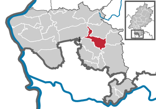
Bergstraße is a Kreis (district) in the south of Hesse, Germany. It is at the northern end of the Bergstraße route. Neighboring districts are Groß-Gerau, Darmstadt-Dieburg, Odenwaldkreis, Rhein-Neckar-Kreis, the urban district Mannheim, the Rhein-Pfalz-Kreis, and the urban district of Worms. Kreis Bergstraße belongs both to the Rhine Neckar Area and the Rhein-Main Region.

The Odenwaldkreis is a Kreis (district) in the south of Hesse, Germany. Neighboring districts are Darmstadt-Dieburg, Miltenberg, Neckar-Odenwald-Kreis, Rhein-Neckar-Kreis and Kreis Bergstraße. Odenwaldkreis belongs to the Rhine Neckar Area.

<span class="mw-page-title-main">Reichelsheim (Odenwald)</span> Municipality in Hesse, Germany

Reichelsheim (Odenwald) is a municipality in the Odenwaldkreis (district) in Hesse, Germany.

<span class="mw-page-title-main">Lindenfels</span> Town in Hesse, Germany

Lindenfels is a town in the Bergstraße district in Hesse, Germany.

<span class="mw-page-title-main">Einhausen, Hesse</span> Municipality in Hesse, Germany

Einhausen is a municipality in the Bergstraße district in Hesse, Germany, some 15 km east of Worms.

<span class="mw-page-title-main">Erbach im Odenwald</span> Town in Hesse, Germany

Erbach is a town and the district seat of the Odenwaldkreis (district) in Hesse, Germany. It has a population of around 13,000.

<span class="mw-page-title-main">Birkenau (Odenwald)</span> Municipality in Hesse, Germany

Birkenau in the Odenwald is a municipality in the Bergstraße district in southern Hesse, Germany. Its nickname is Das Dorf der Sonnenuhren – “The Sundial Village”.

<span class="mw-page-title-main">Feldatal</span> Municipality in Hesse, Germany

Feldatal is a community in the Vogelsbergkreis in Hesse, Germany.

<span class="mw-page-title-main">Wald-Michelbach</span> Municipality in Hesse, Germany

Wald-Michelbach is a community in the Bergstraße district in Hessen, Germany.

<span class="mw-page-title-main">Fürth, Hesse</span> Municipality in Hesse, Germany

Fürth is a community and a state-recognized recreational resort (Erholungsort) in the Bergstraße district in Hesse, Germany.

<span class="mw-page-title-main">Mörlenbach</span> Municipality in Hesse, Germany

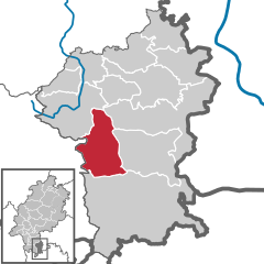
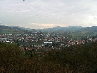
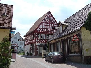
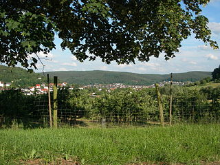
Mörlenbach is a municipality in the Bergstraße district in southern Hesse, Germany.

<span class="mw-page-title-main">Höchst im Odenwald</span> Municipality in Hesse, Germany

Höchst im Odenwald is a community in the Odenwaldkreis (district) in Hesse, Germany.

<span class="mw-page-title-main">Bad König</span> Town in Hesse, Germany

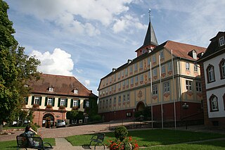
Bad König is a town and resort (Kurort) in the central Odenwald in the Odenwaldkreis (district) in Hesse, Germany, 29 km southeast of Darmstadt.

<span class="mw-page-title-main">Gorxheimertal</span> Municipality in Hesse, Germany

Gorxheimertal is a community in the Bergstraße district in Hesse, Germany. It is in the Odenwald and the Rhine Neckar Area.

<span class="mw-page-title-main">Grasellenbach</span> Municipality in Hesse, Germany

Grasellenbach is a municipality in the Bergstraße district in southern Hesse, Germany.

<span class="mw-page-title-main">Rimbach, Hesse</span> Municipality in Hesse, Germany

Rimbach in the Odenwald is a municipality in the Bergstraße district in southern Hesse, Germany.

<span class="mw-page-title-main">Bickenbach, Hesse</span> Municipality in Hesse, Germany

Bickenbach is a municipality in the Darmstadt-Dieburg district of Hesse, Germany. It is situated on the Hessische Bergstraße wine region.

<span class="mw-page-title-main">Fränkisch-Crumbach</span> Municipality in Hesse, Germany

Fränkisch-Crumbach is a community in the Odenwaldkreis (district) in Hesse, Germany.

<span class="mw-page-title-main">Lützelbach</span> Municipality in Hesse, Germany

Lützelbach is a municipality in the Odenwaldkreis (district) in Hesse, Germany.

<span class="mw-page-title-main">Oberzent</span> Town in Hesse, Germany

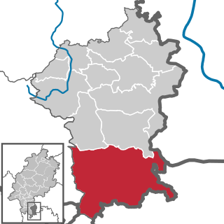
Oberzent is a town in the district of Odenwaldkreis, in Hesse, Germany. It was created with effect from 1 January 2018 by the merger of the former town Beerfelden and the former municipalities of Hesseneck, Rothenberg and Sensbachtal.

References

  1. "Ergebnisse der letzten Direktwahl aller hessischen Landkreise und Gemeinden" (XLS) (in German). Hessisches Statistisches Landesamt. 5 September 2022.
  2. "Bevölkerung in Hessen am 31.12.2020 nach Gemeinden". Hessisches Statistisches Landesamt (in German). June 2021.