At the beginning of the 20th century, it reportedly had an area of 29,220 square miles (75,700km2), while the preliminary results of the first Ottoman census of 1885 (published in 1908) gave the population as 300,280.[4] The accuracy of the population figures ranges from "approximate" to "merely conjectural" depending on the region from which they were gathered.[4]
A map showing the administrative divisions of the Ottoman Empire in 1317 Hijri, 1899 Gregorian, Including the Vilayet of Mosul and its Sanjaks.Map of subdivisions of Mosul Vilayet in 1907
The Treaty of Sèvres was a 1920 treaty signed between the Allies of World War I and the Ottoman Empire. The treaty ceded large parts of Ottoman territory to France, the United Kingdom, Greece and Italy, as well as creating large occupation zones within the Ottoman Empire. It was one of a series of treaties that the Central Powers signed with the Allied Powers after their defeat in World War I. Hostilities had already ended with the Armistice of Mudros.
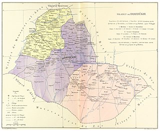
The Vilayet of Diyâr-ı Bekr was a first-level administrative division (vilayet) of the Ottoman Empire, wholly located within what is now modern Turkey. The vilayet extended south from Palu on the Euphrates to Mardin and Nusaybin on the edge of the Mesopotamian plain. After the establishment of Republic of Turkey in 1923, the region was incorporated into the newly created state.
The Vilayet of Baghdad was a first-level administrative division (vilayet) of the Ottoman Empire in modern-day central Iraq. The capital was Baghdad.
The Vilayet of Van was a first-level administrative division (vilayet) of the Ottoman Empire. At the beginning of the 20th century, it reportedly had a population of about 400,000 and an area of 15,000 square miles (39,000 km2).
The Vilayet of Angora or Ankara was a first-level administrative division (vilayet) of the Ottoman Empire, centered on the city of Angora (Ankara) in north-central Anatolia, which included most of ancient Galatia.
Bitlis Vilayet was a first-level administrative division (vilayet) of the Ottoman Empire. Before the Russo-Turkish War (1877–1878) it had been part of the Erzurum Vilayet, it was then made a separate vilayet by the Sublime Porte. It was one of the six Armenian vilayets of the Empire.
The Hüdavendigâr Vilayet or Bursa Vilayet after its administrative centre, was a first-level administrative division (vilayet) of the Ottoman Empire. At the beginning of the 20th century it reportedly had an area of 26,248 square miles (67,980 km2).
The Basra Vilayet was a first-level administrative division (vilayet) of the Ottoman Empire. It historically covered an area stretching from Nasiriyah and Amarah in the north to Kuwait in the south. To the south and the west, there was theoretically no border at all, yet no areas beyond Qatar in the south and the Najd Sanjak in the west were later on included in the administrative system.
Sheikh Mahmud Barzanji or Mahmud Hafid Zadeh was a Kurdish leader of a series of Kurdish uprisings against the British Mandate of Iraq. He was sheikh of a Qadiriyah Sufi family of the Barzanji clan from the city of Sulaymaniyah, which is now in Iraqi Kurdistan. He was named King of Kurdistan during several of these uprisings.
Kifri is the central town of Kifri District in Diyala Governorate, Iraq. It has a mixed population of Arabs, Kurds and Turkmen. It is under de facto administration by Kurdistan Region, but remains a disputed area claimed by the central government.
The Vilayet of Aidin or Aydin also known as Vilayet of Smyrna or Izmir after its administrative centre, was a first-level administrative division (vilayet) of the Ottoman Empire in the south-west of Asia Minor, including the ancient regions of Lydia, Ionia, Caria and western Lycia. It was described by the 1911 Encyclopædia Britannica as the "richest and most productive province of Asiatic Turkey".
The Vilayet of Kastamonu was a first-level administrative division (vilayet) of the Ottoman Empire, established in 1867 and abolished in 1922. At the beginning of the 20th century, the vilayet reportedly had an area of 19,300 square miles (50,000 km2), while the preliminary results of the first Ottoman census of 1885 gave the population as 1,009,460. The accuracy of the population figures ranges from "approximate" to "merely conjectural" depending on the region from which they were gathered.
The Vilayet of Beirut was a first-level administrative division (vilayet) of the Ottoman Empire. It was established from the coastal areas of the Syria Vilayet in 1888 as a recognition of the new-found importance of its then-booming capital, Beirut, which had experienced remarkable growth in the previous years — by 1907, Beirut handled 11 percent of the Ottoman Empire's international trade. It stretched from just north of Jaffa to the port city of Latakia. It was bounded by the Syria Vilayet to the east, the Aleppo Vilayet to the north, the autonomous Mutasarrifate of Jerusalem to the south and the Mediterranean Sea to the west.
The Vilayet of Syria, also known as Vilayet of Damascus, was a first-level administrative division (vilayet) of the Ottoman Empire.
A vilayet, also known by various other names, was a first-order administrative division of the later Ottoman Empire. It was introduced in the Vilayet Law of 21 January 1867, part of the Tanzimat reform movement initiated by the Ottoman Reform Edict of 1856. The Danube Vilayet had been specially formed in 1864 as an experiment under the leading reformer Midhat Pasha. The Vilayet Law expanded its use, but it was not until 1884 that it was applied to all of the empire's provinces. Writing for the Encyclopaedia Britannica in 1911, Vincent Henry Penalver Caillard claimed that the reform had intended to provide the provinces with greater amounts of local self-government but in fact had the effect of centralizing more power with the sultan and local Muslims at the expense of other communities.
The Mosul question was a territorial dispute in the early 20th century between Turkey and the United Kingdom over the possession of the former Ottoman Mosul vilayet.
The Vilayet of Adana was a first-level administrative division (vilayet) of the Ottoman Empire in the south-east of Asia Minor, which encompassed the region of Cilicia. It was established in May 1869. Adana Vilayet bordered with Konya Vilayet, Ankara Vilayet and Sivas Vilayet, and Haleb Vilayet. Adana Vilayet corresponds to the modern region of Çukurova in Turkey.
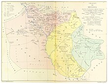
The Sanjak of Mosul or Mosul Sanjak was a sanjak in the Ottoman Empire with the city of Mosul, in present-day Iraq, as its administrative center.
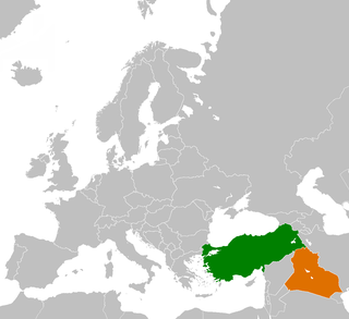
The Iraq–Turkey border is 367 km in length and runs from the tripoint with Syria in the west to the tripoint with Iran in the east.
This page is based on this Wikipedia article Text is available under the CC BY-SA 4.0 license; additional terms may apply. Images, videos and audio are available under their respective licenses.