
The Brooks Range is a mountain range in far northern North America stretching some 700 miles (1,100 km) from west to east across northern Alaska into Canada's Yukon Territory. Reaching a peak elevation of 8,976 feet (2,736 m) on Mount Isto, the range is believed to be approximately 126 million years old.

Mount Columbia is a mountain located in the Winston Churchill Range of the Rocky Mountains. It is the highest point in Alberta, Canada, and is second only to Mount Robson for height and topographical prominence in the Canadian Rockies. It is located on the border between Alberta and British Columbia on the northern edge of the Columbia Icefield. Its highest point, however, lies within Jasper National Park in Alberta.

The North Fork of the Koyukuk River is one of the principal forks of the Koyukuk River, approximately 105 mi (160 km) long, in northern Alaska in the United States. It has a watershed area of 1,850 square miles (4,800 km2). It rises on the south slopes of the Continental Divide in the Brooks Range.

Mount Johnson is an 8,400+ ft mountain summit located in the Alaska Range, in Denali National Park and Preserve, in Alaska, United States. It is situated on the west side of the Ruth Gorge, 15 miles (24 km) southeast of Denali and six miles (9.7 km) south-southwest of The Moose's Tooth. The nearest higher neighbor is Mount Wake, 0.69 miles (1.11 km) to the northwest.
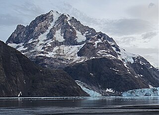
Mount Abbe is an 8200+ feet double summit mountain located in the Fairweather Range of the Saint Elias Mountains, in southeast Alaska. The peak is situated near the terminus of the Johns Hopkins Glacier, within Glacier Bay National Park and Preserve, 100 mi (161 km) northwest of Juneau, and 8.2 mi (13 km) northeast of Mount Orville. Although modest in elevation, relief is significant since the mountain rises up from tidewater in less than two miles. Mount Abbe is often seen and photographed with the Johns Hopkins Glacier, which is a popular destination for cruise ships. The mountain was named in 1936 by William Osgood Field and William Skinner Cooper, of the American Geographical Society, for Cleveland Abbe Jr., (1872-1934), an American geographer. Abbe received a Ph.D. in 1898 from Johns Hopkins University. The Gilman Glacier and Clark Glacier on the mountain's slopes were named for Daniel Coit Gilman, the institution's first president, and William Bullock Clark who was a professor of geology at the university. The mountain's name was officially adopted in 1937 by the United States Geological Survey. The first ascent of the south summit was made June 11, 1977, by Jim Wickwire and Dusan Jagersky via the Southeast Face. Three days later, Dusan Jagersky was killed while descending an unnamed peak. The first ascent of the north summit was made July 14, 1991, by Walter Gove and William Pilling. The months May through June offer the most favorable weather for climbing Mount Abbe, but it's a challenging climb in any conditions, with few attempts.

Mount Wordie is a 4,700+ foot mountain summit located in Glacier Bay National Park and Preserve, in the Alsek Ranges of the Saint Elias Mountains, in southeast Alaska. The mountain is situated 80 mi (129 km) northwest of Juneau, 4 mi (6 km) south of Carroll Glacier, and 3.1 mi (5 km) north of Mount Merriam which is the nearest higher peak. Although modest in elevation, relief is significant as the mountain rises up from tidewater in less than two miles. Precipitation runoff from the mountain drains into Glacier Bay Basin. Weather permitting, Mount Wordie can be seen from Queen Inlet and Wachusett Inlet of Glacier Bay, which is a popular destination for cruise ships.
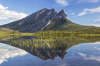
Sukakpak Mountain is a prominent 4,459-foot mountain summit located in the Philip Smith Mountains of the Brooks Range, in the U.S. state of Alaska. The peak is situated 90 miles north of the Arctic Circle near milepost 203 on the Dalton Highway, and 200 mi (322 km) north-northwest of Fairbanks, where the Bettles and Dietrich Rivers merge to form Middle Fork Koyukuk River. The peak's Sukakpak name was reported in 1930 by the USGS as an Inupiat word, said to mean "marten deadfall." From the north, the mountain resembles a carefully balanced log used to trap marten. The name was officially adopted in 1932 by the U.S. Board on Geographic Names.

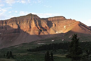
Dillon Mountain is a prominent 4,820-foot mountain summit located in the Philip Smith Mountains of the Brooks Range, in the U.S. state of Alaska. The peak is situated 93 miles north of the Arctic Circle near milepost 207 on the Dalton Highway, and 200 mi (322 km) north-northwest of Fairbanks, where the Bettles and Dietrich Rivers merge to form Middle Fork Koyukuk River. Sukakpak Mountain rises 3 mi (5 km) to the southwest, and Dietrich Camp of the Trans-Alaska Pipeline lies 3 mi (5 km) to the northwest. The peak was named after John Thomas Dillon (1947-1987), a geologist with the Alaska Division of Geological and Geophysical Surveys who mapped the geology of the southern Brooks Range mineral belt. He died tragically with his father, Stephen Patrick Dillon, in an airplane crash in the Brooks Range while returning home from field work in July 1987. The name was officially adopted in 1990 by the U.S. Board on Geographic Names. This landmark is notable for its massive west face composed of Skajit limestone rising nearly 3,400 feet above the surrounding valley.
Poss Mountain is a prominent 6,180-foot mountain summit located in the Philip Smith Mountains of the Brooks Range, in the U.S. state of Alaska. The peak is situated 80 miles north of the Arctic Circle, five miles east of Dalton Highway, 11.3 mi (18 km) south of Sukakpak Mountain, and 190 mi (306 km) north-northwest of Fairbanks. The peak was named about 1930 by wilderness activist Robert Marshall after "Poss" Postlethwaite, an early and old gold prospector in this area around Wiseman. Robert Marshall described the then 78-year-old Postlethwaite as "the oldest man in the Koyukuk," having spent 32 winters in the area. The name was officially adopted in 1932 by the U.S. Board on Geographic Names. The Poss Mountain Research Natural Area was designated in 1991 to protect natural mineral licks and lambing habitat for Dall sheep. Precipitation runoff from the mountain drains into tributaries of the Middle and South Forks of Koyukuk River.

Mount Huxley is a 12,216-foot glaciated mountain summit located in the Saint Elias Mountains of Wrangell-St. Elias National Park and Preserve, in the U.S. state of Alaska. The remote peak is situated 75 mi (121 km) northwest of Yakutat, and 8.7 mi (14 km) west-northwest of Mount Saint Elias. The peak rises above the Columbus Glacier and Bagley Icefield to its north, the Tyndall Glacier to the south, and the Yahtse Glacier to the west. Precipitation runoff from the mountain drains into the Gulf of Alaska. The mountain was named in 1886 by English mountaineer Harold Ward Topham for Thomas Henry Huxley (1825-1895), an English biologist. The mountain was officially named Huxley Peak in 1917, but the name was officially changed to Mount Huxley in 1968 by the U.S. Board on Geographic Names. The first ascent of the peak was made June 9, 1996 by Paul Claus who landed his plane at 11,500 feet elevation on the western flank and climbed the remaining distance to the summit. The second ascent of Mt. Huxley, and first complete ascent from base to summit, was made in June 2018 by Scott Peters, Andrew Peter, and Ben Iwrey starting from the Columbus Glacier.

Mount Goode is a 13,085-foot-elevation mountain summit located on the crest of the Sierra Nevada mountain range in California, United States. It is situated on the shared boundary of Kings Canyon National Park with John Muir Wilderness, and along the common border of Fresno County with Inyo County. It is also approximately one mile west-northwest of Bishop Pass, one mile east-southeast of Mount Johnson, 1.23 miles (1.98 km) south of Hurd Peak, and 16 miles (26 km) west of the community of Big Pine.

Dead Horse Peak is a 12,642-foot elevation (3,853 m) mountain summit located on the common border that Duchesne County shares with Summit County in the U.S. state of Utah.

The Cathedral is a 12,224-foot elevation (3,726 m) mountain summit located in Summit County, Utah, United States.

Wasatch Peak is a 13,156-foot elevation (4,010 m) mountain summit located in Summit County, Utah, United States.
Little Regret Peak is an 11,090-foot elevation (3,380 m) mountain summit located in Custer County, Idaho, United States.

Easley Peak is an 11,108-foot elevation (3,386 m) mountain summit located on the common border that Blaine County shares with Custer County, in Idaho, United States.
Henrys Fork Peak is a 13,260-foot elevation (4,042 m) mountain summit located on the common border that Duchesne County shares with Summit County in the U.S. state of Utah.
Kahiltna Queen is a 12,380-foot-elevation (3,773-meter) mountain summit in the U.S. state of Alaska.

Mount Ada is a 4,528-foot-elevation (1,380-meter) mountain summit in Alaska, United States.

Mount Geist is a 10,716-foot-elevation (3,266-meter) mountain summit in Alaska, United States.


