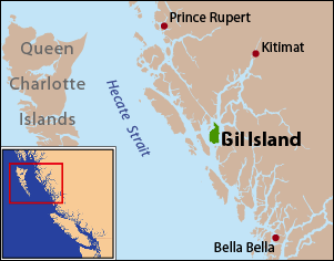
Gil Island is an island on the North Coast of British Columbia, Canada, located on the west side of Whale Channel in the entrance to Douglas Channel, one of the main coastal inlets, on the route of the Inside Passage between Pitt Island and Princess Royal Island. It is 26 km (16 mi) long, with a width ranging from 6 to 13 km, and an area of 231 km2. The only named summit on the mountainous island is Mount Gil, which faces the opening of Douglas Channel.

Hagensborg, originally named Kristiania, is a small community in the Bella Coola Valley in British Columbia, Canada. Its census population in 2006 was 248.

The Gwa'sala-Nakwaxda'xw Nations are an amalgamation of two Kwakwaka'wakw peoples in a band government based on northern Vancouver Island in British Columbia, whose main reserve community is near the town of Port Hardy in the Queen Charlotte Strait region of the Central Coast region of British Columbia, Canada. In the 1960s the Gwa'sala (Gwaʼsa̱la), the 'Nakwaxda'xw (ʼNakʼwaxdaʼx̱w) and the Kwakiutl peoples were amalgamated. Later the Gwa'sala-'Nakwaxda'xw Nations and the Kwakiutl First Nation separated into the two groups that are recognized by the federal government. Gwa'sala-'Nakwaxda'xw Nations were forcibly relocated from their homelands to a location near Port Hardy.
The Lytton First Nation, a First Nations band government, has its headquarters at Lytton in the Fraser Canyon region of the Canadian province of British Columbia. While it is the largest of all Nlaka'pamux bands, unlike all other governments of the Nlaka'pamux (Thompson) people, it is not a member of any of the three Nlaka'pamux tribal councils, which are the Nicola Tribal Association, the Fraser Canyon Indian Administration and the Nlaka'pamux Nation Tribal Council.
The Tlʼetinqox-tʼin Government Office is a First Nations government located in the Chilcotin District in the western Central Interior region of the Canadian province of British Columbia. Governing a reserve communities near Alexis Creek known as Anaham Reserve First Nations or Anaham, it is a member of the Tsilhqotʼin Tribal Council aka known as the Tsilhqotʼin National Government. The main reserve is officially known as Anahim's Flat No. 1, and is more commonly as Anaham. Other reserves are Anahim's Meadow No. 2 and 2A, and Anahim Indian Reserves Nos. 3 through 18. Anaham, or Anahim and Alexis were chiefs of the Tsilhqotʼin during the Chilcotin War of 1864, although they and their people did not take part in the hostilities.
The Pattullo Range is a subrange of the Hazelton Mountains, located south of Tesla Lake and northeast of Bella Coola in northern British Columbia, Canada. Its highest summit is Tsaydaychuz Peak, 2758 m.
The Hartley Bay Indian Band is also known as the Gitga'at First Nation or the Hartley Bay First Nation. The members of the Gitga'at First nation are often referred to as Gitka'a'ata. The population of Gitk’a’ata peoples living in Hartley Bay ranges from approximately 130-200 people. There are also about 400-500 Gitk’a’ata peoples living in Prince Rupert, British Columbia, Canada, a neighboring territory. The Gitk’a’ata people have lived in Hartley Bay for hundreds of years, if not always. Some notable things regarding the Gitga'at First Nation are their economy, geography, government, sports involvement, COVID-19 regulations, and relations.
The Tlowitsis Nation, formerly the Klowitsis Tribe, the Turnour Island Band and the Tlowitsis-Mumtagila First Nation, is the Indian Act band government of the Ławit'sis (Tlowitsis) tribe of the Kwakwaka'wakw peoples, located in the Queen Charlotte Strait-Johnstone Strait area in the Discovery Islands between Vancouver Island and the British Columbia mainland in Canada. Ławit'sis territory covers parts of northern Vancouver Island, Johnstone Strait, and adjoining inlets of the mainland. Kalugwis, on Turnour Island, was their principal community in times past, but the band's offices are in the city of Campbell River to the southeast. Hanatsa IR No. 6 on Port Neville is the most populated of the band's Indian reserves.
The Nusatsum River is a river in the Bella Coola Valley of the Central Coast region of British Columbia, Canada. It is a tributary of the Bella Coola River, flowing northwest to meet that river just upstream of the community of Hagensborg.
Salloomt Peak is a 1,873 metres (6,145 ft) high mountain in the Kitimat Ranges of the Coast Mountains in the Bella Coola Valley region of British Columbia, Canada. It is located on the north side of the Bella Coola River between the communities of Firvale and Hagensborg.
The Noosgulch River is a river in the Bella Coola Valley of the Central Coast region of British Columbia, Canada, flowing southwest from the southernmost Kitimat Ranges to meet the Bella Coola River just north of Nusatsum Mountain.
Noohalk Mountain 2099 m is a mountain in the northernmost Pacific Ranges of the Coast Mountains in British Columbia, Canada. It is located on the south side of the Bella Coola Valley between Hagensborg and Bella Coola.
Chatscah Indian Reserve No. 2, officially Chatscah 2 is an Indian reserve of the Nuxalk Nation band government, located at the mouth of the Kimsquit River at the head of Dean Channel. Like nearby Kimsquit, at the mouth of the Dean River to the southeast, this Indian reserve was one of two reserves set aside of the once-populous Kimsquit subgroup of the Nuxalk, whose surviving post-smallpox population gathered at Bella Coola.
Comet Mountain, 1742 m, is a mountain in the Kitimat Ranges of British Columbia, Canada, located immediately west of the head of Dean Channel in the Central Coast region of that province, to the northwest of the town of Bella Coola. The former Nuxalk village and still-Indian reserve Kimsquit is located immediately east across Dean Channel, Chatscah Indian Reserve No. 2 is immediately north at the mouth of the Kimsquit River.
The Noeick River is a river in the Central Coast region of British Columbia, Canada, flowing west out of the northernmost Pacific Ranges to enter saltwater on the east side of South Bentinck Arm, immediately to the north of the mouth of the Taleomey River at Taleomey Narrows.
Mount Saugstad is a mountain in the northernmost Pacific Ranges of the Coast Mountains in the Central Coast region of British Columbia, Canada. It is located just south of the community of Hagensborg in the Bella Coola Valley and is immediately southeast of Snootli Peak and also southeast of Big Snow Mountain. The Smitley River has its origins on the west side of the summit at the Saugstad Glacier, which is at 52°15′48″N126°31′36″W
There are many lakes named Long Lake in British Columbia, Canada.

Port Neville is a bay, port and locality on the north side of Johnstone Strait, south of Call Inlet, in the Central Coast region of British Columbia, Canada.
Waddington Harbour is a harbour at the head of Bute Inlet in the Central Coast region of British Columbia, Canada. Also issuing into the head of Bute Inlet and Waddington Harbour, just east of the mouth of the Homathko, is the Teaquahan River. Issuing directly into the inlet a few miles south on the harbour's southeast is the Southgate River, one of the major rivers of the central Pacific Ranges, which begins on the west side of the Lillooet Icecap. Its lower valley adjacent to the inlet's shores is called Pigeon Valley.
Mosely Creek is a large creek in the Pacific Ranges of the Coast Mountains in British Columbia, Canada, flowing southwest to join the Homathko River in its canyon downstream from Tatlayoko Lake, and a short distance above Murderers Bar at 51°16′00″N124°54′00″W, which is the site of the opening events of the Chilcotin War of 1864.

