Cape Arid National Park is a national park located in Western Australia, 731 kilometres (454 mi) southeast of Perth. The park is situated 120 kilometres (75 mi) east of Esperance and lies on the shore of the south coast from the eastern end of the Recherche Archipelago.

Waychinicup National Park is in Western Australia, 404 kilometres (251 mi) southeast of Perth and 65 kilometres (40 mi) east of Albany, along the coast of the Southern Ocean.

Broken Bay, a semi-mature tide-dominated drowned valley estuary, is a large inlet of the Tasman Sea located about 50 kilometres (31 mi) north of Sydney on the Central Coast of New South Wales, Australia; being one of the bodies of water that separate greater Metropolitan Sydney from the Central Coast. Broken Bay is the first major bay north of Sydney Harbour in the state capital of Sydney.

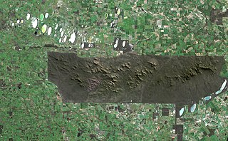
The You Yangs are a series of granite ridges that rise up to 319 m (1,047 ft) above the flat and low-lying Werribee Plain in southern Victoria, Australia, approximately 5 km (3.1 mi) due west of the rural town of Little River, 55 km (34 mi) southwest of Melbourne CBD and 22 km (14 mi) north of Geelong. The main ridge runs roughly north-south for about 9 km (5.6 mi), with a lower extension running for about 15 km (9.3 mi) to the west. Much of the southern parts of the ranges are protected by the You Yangs Regional Park.
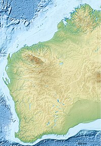
The Stirling Range or Koikyennuruff is a range of mountains and hills in the Great Southern region of Western Australia, 337 kilometres (209 mi) south-east of Perth. It is over 60 kilometres (37 mi) wide from west to east, stretching from the highway between Mount Barker and Cranbrook eastward past Gnowangerup. The Stirling Range is protected by the Stirling Range National Park, which was gazetted in 1913, and has an area of 1,159 km2 (447 sq mi).

Warren, also known as Karri Forest Region and the Jarrah-Karri forest and shrublands ecoregion, is a biogeographic region in southern Western Australia. Located in the southwest corner of Western Australia between Cape Naturaliste and Albany, it is bordered to the north and east by the Jarrah Forest region. Its defining characteristic is an extensive tall forest of Eucalyptus diversicolor (karri). This occurs on dissected, hilly ground, with a moderately wet climate. Karri is a valuable timber and much of the karri forest has been logged over, but less than a third has been cleared for agriculture. Recognised as a region under the Interim Biogeographic Regionalisation for Australia (IBRA), and as a terrestrial ecoregion by the World Wide Fund for Nature, it was first defined by Ludwig Diels in 1906.

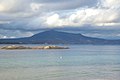
Two Peoples Bay Nature Reserve is a protected area managed by the Department of Parks and Wildlife 35 kilometres (22 mi) east of Albany, Western Australia. The area is accessible by 2WD vehicles. The bay itself, including two small secluded beaches, faces due east and is protected from the Southern Ocean by a headland formed by the granite massif of Mount Gardner. The nature reserve was established in 1967 to protect the threatened noisy scrub-bird and its habitat. It is known for being the site of the discovery and naming of Gilbert's potoroo, but in 2015 a huge fire destroyed 90% of the tiny marsupial's habitat, as well as killing three-quarters of the remaining small population.
Manypeaks is a town located 434 km south-east of Perth and 38 km north-east of Albany in the Great Southern region of Western Australia. The township is on the South Coast Highway close to the intersection with Howie Road. The closest towns to Manypeaks are both on the South Coast highway and are Albany to the south-west and Wellstead to the east. The town lies close to the three lakes of the Lake Pleasant View System Important Bird Area.

Bald Island is an island that is located in the Great Southern region of Western Australia. The island is 1.5 kilometres (1 mi) offshore from Cheynes Beach and is a protected area managed by the Department of Parks and Wildlife.
Coffin Island is an island that is located in the Great Southern region of Western Australia. The island is 300 metres (984 ft) offshore from Two Peoples Bay Nature Reserve and the island is also a protected area making up part of the reserve. With an area of 28 hectares the island is made up mostly of granite.
The south coast of Western Australia comprises the Western Australian coastline from Cape Leeuwin to Eucla. This is a distance of approximately 1,600 kilometres (1,000 mi), fronting the Great Australian Bight and the Southern Ocean.
Angove River or Angove Creek is a river located in the Great Southern region of Western Australia most of the river is found within Two Peoples Bay Nature Reserve.
Angove Lake is a permanent fresh water lake in the Great Southern region of Western Australia, within the Two Peoples Bay Nature Reserve.

The Nuyts Archipelago is an island group in South Australia in the Great Australian Bight, to the south of the town of Ceduna on the west coast of the Eyre Peninsula. It consists of mostly granitic islands and reefs that provide breeding sites for Australian sea lions and support colonies of short-tailed shearwater. It also includes the island group known as the Isles of St Francis. All the islands, with the exception of a part of Evans Island, are located within the protected areas of the Nuyts Archipelago Wilderness Protection Area and the Nuyts Archipelago Conservation Park.
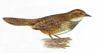
The Two Peoples Bay and Mount Manypeaks Important Bird Area is a 261 km2 tract of coastal and subcoastal land east of the city of Albany in south-west Western Australia. It is an important site for the conservation of several rare and threatened birds.
Hopkins Island is an island located in Spencer Gulf off the east coast of Jussieu Peninsula on Eyre Peninsula in South Australia approximately 32 km (20 mi) south-east of Port Lincoln. It was named by Matthew Flinders in memory of John Hopkins who was one of the eight crew lost from a cutter that capsized on 21 February 1802. Since 2004, the island has been part of the Memory Cove Wilderness Protection Area.

Middle Island is an island off the south coast of Western Australia in the Recherche Archipelago, around 120 km (75 mi) south-east of Esperance. It is known for its pink lake, Lake Hillier. Goose Island lies just adjacent to the north.
Topgallant Islands is an island group in the Australian state of South Australia located in the Investigator Group about 22 kilometres south west of Cape Finniss on the west coast of Eyre Peninsula. The group was discovered and named by Matthew Flinders on 13 February 1802. The island group has enjoyed protected area status since the 1960s and since 2011, it has been part of the Investigator Group Wilderness Protection Area.
Pearson Isles is an island group located in the Australian state of South Australia about 65 kilometres to 72 kilometres west south-west of Cape Finniss on the west coast of Eyre Peninsula within the larger island group, the Investigator Group. The group was discovered and named by Matthew Flinders on 13 February 1802. The group has four members - Pearson Island, a pair of islands known as the Veteran Isles and Dorothee Island. The island group has enjoyed protected area status starting in 1916 and since 2011, it has been part of the Investigator Group Wilderness Protection Area. The island group is notable as a venue for scientific research.
Royston Island is an island in the Australian state of South Australia at the northern end of Pondalowie Bay on the south-west extremity of Yorke Peninsula about 13 kilometres north-west of the town of Stenhouse Bay. The island has enjoyed protected area status since 1967 and since 1972, it has been part of the Innes National Park.