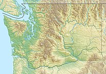
The North Cascades are a section of the Cascade Range of western North America. They span the border between the Canadian province of British Columbia and the U.S. state of Washington and are officially named in the U.S. and Canada as the Cascade Mountains. The portion in Canada is known to Americans as the Canadian Cascades, a designation that also includes the mountains above the east bank of the Fraser Canyon as far north as the town of Lytton, at the confluence of the Thompson and Fraser Rivers.

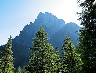
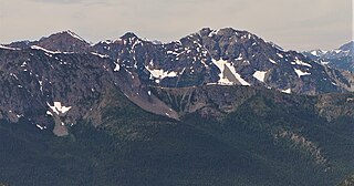
Mount Index is a peak in the central part of the Cascade Range of Washington state. It lies just south of the Skykomish River and U.S. Route 2, at the western edge of the Cascades. Despite its low elevation relative to peaks higher in the Cascades, it is a famous and dramatic landmark due to its topographic prominence. It comprises three pointed spires which rise steeply from a very low base. The main peak is the southernmost of the three, while the North Peak rises even more steeply above the valley. For example, it rises more than 4,250 ft (1,300 m) above the lower slopes on the northeast side in less than 1 horizontal mile (1.6 km).
Baring Mountain, is a peak in the central part of the Cascade Range of Washington, United States. It lies about 2 miles (3.2 km) northeast of the Skykomish River and US Highway 2, at the western edge of the Cascades in the Mount Baker-Snoqualmie National Forest. It is about 6 miles (9.7 km) east of Mount Index and Barclay Lake at its base is accessible via Forest Road 6024 and a 2.2-mile (3.5 km) hike.

Mount Blum, or Mount Bald, is a 7,685-foot (2,342 m) summit of the North Cascades range in Washington state, on the western edge of North Cascades National Park. It is the highest summit of a string of mountain peaks located east of Mount Shuksan and west of the Picket Range. Two small active glaciers rest on its northern flank. Mount Blum was named after John Blum, a United States Forest Service fire patrol pilot who perished in a plane crash near Snoqualmie Pass in 1931.

The geography of the North Cascades describes a range of rugged mountains in British Columbia, Canada and Washington, United States. In Canada, the range is officially named the Cascade Mountains but is commonly referred to as the Canadian Cascades.

Mount Fernow is a tall peak in the North Cascades in the U.S. state of Washington and within the Glacier Peak Wilderness of the Wenatchee National Forest. At 9,249 feet (2,819 m) in elevation it is the eighth-highest peak in Washington and the state's third-highest non-volcanic peak. It is also the highest peak of the Entiat Mountains, a sub-range of the Cascades. Mount Fernow's prominence is 2,811 ft (857 m), making it the sixtieth-most-prominent peak in Washington. The closest peak to Fernow is Copper Peak, 0.88 mi (1.42 km) to the north, and the nearest higher peak is Bonanza Peak, 5.9 mi (9.5 km) to the north.

Buckner Mountain is a tall peak in the North Cascades of Washington state and in the Stephen Mather Wilderness of North Cascades National Park. At 9,114 feet (2,778 m) in elevation it is the highest in Skagit County and one of about ten of Washington's non-volcanic peaks above 9,000 feet high. It is ranked as the 14th highest peak in the state, and the third highest peak in North Cascades National Park.

Mount Redoubt is a mountain in the North Cascades range in Whatcom County, Washington state. The peak is located 3.0 miles (5 km) from the Canada–US border, 16.3 miles (26 km) east-northeast of Mount Shuksan. It is the 21st highest peak in the state, with a height of 8,956 feet (2,730 m) and a prominence of 1,649 feet (503 m). Redoubt is in the Skagit Range, a sub-range of the North Cascades, in the Custer-Chilliwack Group which includes Mount Spickard, Mount Redoubt, Mount Custer and Mox Peaks, among others. Redoubt, Bear, and Depot creeks drain off the mountain, which is composed of Skagit gneiss. Mount Redoubt is listed as one of the "Classic Eight Peaks" in the North Cascades.

Mount Spickard is a 8,980-foot (2,740 m) mountain peak in the North Cascades, a mountain range in the U.S. state of Washington. Located 2 miles (3.2 km) south of the Canada–US border, it is part of the Chilliwack Group, a subrange of the Skagit Range which is part of the North Cascades. It is composed mainly of gneiss and is part of two major drainage basins: that of the Skagit River and Fraser River.

Sacajawea Peak is a peak in the Wallowa Mountains, in the U.S. state of Oregon. It is in the Eagle Cap Wilderness and the Wallowa–Whitman National Forest.

Mount Larrabee is a 7,865-foot (2,397-metre) Skagit Range mountain summit situated 1.4 mile south of the Canada–United States border, in the North Cascades of Washington state. It is located immediately southeast of American Border Peak within the Mount Baker Wilderness, which is part of the Mount Baker-Snoqualmie National Forest, and near North Cascades National Park. It is notable for its reddish coloring caused by oxidation of Iron in the rock. The rock consists of reddish interbedded and interfolded phyllites and greenstone. Originally known as Red Mountain, the name was changed in 1951 to honor Charles F. Larrabee (1895–1950), of the prominent Larrabee family of Bellingham, Washington. The toponym was officially adopted in 1951 by the U.S. Board on Geographic Names.

Mount Ballard is an 8,371-foot (2,551-metre) double-summit mountain located in eastern Whatcom County of Washington state. It is part of the Okanogan Range which is a sub-range of the North Cascades Range, and the mountain is situated on land administered by the Okanogan–Wenatchee National Forest. Ballard ranks 84th on Washington's highest 100 peaks. The nearest higher neighbor is Azurite Peak, 2.04 miles (3.28 km) to the south. Precipitation runoff from Mount Ballard drains into Mill Creek and Slate Creek, both tributaries of the Skagit River. Topographic relief is significant as the summit rises approximately 4,000 feet above Mill Creek in one mile (1.6 km).

Castle Peak is a prominent 8,343-foot (2,543-metre) mountain summit located in the Hozameen Range of the North Cascades, on the shared border between Okanogan County and Whatcom County of Washington state. The mountain is situated one mile (1.6 km) south of the Canada–United States border, on the Cascade crest, in the Pasayten Wilderness, on land managed by the Okanogan–Wenatchee National Forest. The nearest higher peak is Jack Mountain, 14.8 miles (23.8 km) to the south-southwest. Castle Peak is the second highest summit of the Hozameen Range following Jack Mountain. Castle Peak is the sixth-highest mountain in the Pasayten Wilderness. Precipitation runoff from the mountain drains east into Castle Creek, a tributary of the Similkameen River, or west into tributaries of the Skagit River. Topographic relief is significant as the summit rises nearly 3,000 feet above Crow Creek in 0.75 mile (1.2 km).
Mount Carru is an 8,595-foot (2,620-metre) mountain summit located in western Okanogan County in Washington state. It is the seventh-highest peak of the Okanogan Range, which is a sub-range of the North Cascades. The mountain is situated in the Pasayten Wilderness on land administered by the Okanogan–Wenatchee National Forest. The nearest higher peak is Mount Lago, 0.8 mile to the east, and Osceola Peak rises one mile (1.6 km) west. The mountain has a steep north face, but the south slope is covered in scree which allows a nontechnical climbing ascent. Precipitation runoff from Mount Carru drains north into Lease Creek which is a tributary of the Pasayten River, or south into Eureka Creek, which is part of the Methow River drainage basin.

Genesis Peak is a 7,244-foot (2,208-metre) mountain summit located in the North Cascades, in Whatcom County of Washington, United States. It is situated within North Cascades National Park and Stephen Mather Wilderness. The nearest higher neighbor is Mount Prophet, 2.22 miles (3.57 km) to the northwest. Like many North Cascade peaks, Genesis Peak is more notable for its large, steep rise above local terrain than for its absolute elevation. Topographic relief is significant since the southern aspect of the mountain rises 5,400 feet above the Big Beaver Valley in approximately two miles (3.2 km), and the eastern aspect of the mountain rises 5,600 feet above Ross Lake in approximately three miles (4.8 km). Precipitation runoff from the mountain drains into Ross Lake via Skymo, No Name, and Big Beaver Creeks. The first ascent of this peak was made September 13, 1975, by Norman Burke, Cliff Lawson, Ed Lebert, and Dan Sjolseth.
Elija Ridge is a prominent 7,739 ft (2,360 m) ridge located in North Cascades National Park, in Whatcom County of Washington state. It is part of the North Cascades which is a subset of the Cascade Range. The highest point is called Elija Peak, and another peak on this ridge with sufficient prominence to qualify as a separate summit is called Ezekiel,. The nearest higher neighbor is Gabriel Peak, 1.9 miles (3.1 km) to the southeast, Beebe Mountain is set 1.86 miles (2.99 km) to the northeast, and Ruby Mountain is 4.86 miles (7.82 km) to the northwest. Precipitation runoff from this ridge drains to Ross Lake via Panther Creek. This geographical feature is named after the prophet Elija, which is a reference to Tommy Rowland who settled in the Skagit River area in 1895 and later pronounced himself the "Prophet Elisha." Gabriel Peak, Genesis Peak, and Mount Prophet are also named in association with Rowland.

Gabriel Peak is a prominent 7,920-foot (2,410 m)-elevation mountain summit located in North Cascades National Park, in Skagit County of Washington state. It is part of the North Cascades which is a subset of the Cascade Range. The nearest higher neighbor is Cosho Peak, 2.7 miles (4.3 km) to the south, Beebe Mountain is set 2.5 miles (4.0 km) to the north, and Red Mountain is 3 miles (4.8 km) to the southwest. Precipitation runoff from this feature drains to Ross Lake via Gabriel and Panther Creeks. Like many North Cascade peaks, Gabriel Peak is more notable for its large, steep rise above local terrain than for its absolute elevation. Topographic relief is significant as it rises 4,700 feet (1,400 m) above the Panther Creek valley in approximately one mile. This geographical feature is named after the archangel Gabriel, which is a reference to Tommy Rowland who settled in the Skagit River area in 1895 and later pronounced himself the "Prophet Elisha." Mount Prophet, Genesis Peak, and nearby Elija Ridge were also named in association with Rowland.
Majestic Mountain is a 7,530-foot-elevation (2,295-meter) mountain summit located in Whatcom County in Washington state.
Mount Buckindy is a remote 7,320-foot-elevation (2,230-meter) mountain summit located in the North Cascades, in Skagit County of Washington state. It is the second-highest point of the Buckindy Range, or Buckindy Ridge. It is set in the Glacier Peak Wilderness on land managed by the Mount Baker-Snoqualmie National Forest. It is situated 20 miles east-northeast of Darrington, Washington, and 17 miles north-northwest of Glacier Peak which is one of the Cascade stratovolcanoes. Precipitation runoff from Mount Buckindy drains south to the Suiattle River via Buck Creek and Downey Creek, and north to the Cascade River via Kindy Creek. Topographic relief is significant as the summit rises 4,700 feet above Kindy Creek in less than two miles. The mountain's toponym is a portmanteau of Buck and Kindy Creeks, and has been officially adopted by the United States Board on Geographic Names.