
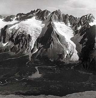
Mount Foresta is an 11,000+ ft multi-peak massif located in Wrangell–St. Elias National Park, in the Saint Elias Mountains of Alaska in the United States. Rising high above the lower western margin of the Hubbard Glacier, the summit of Mount Foresta is just over nine miles (14 km) from tidewater at Disenchantment Bay, 12 mi (19 km) northwest of Mount Seattle, 14.5 mi (23 km) southeast of Mount Vancouver, and 46 mi (74 km) north of Yakutat.
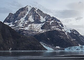
Mount Abbe is an 8200+ feet double summit mountain located in the Fairweather Range of the Saint Elias Mountains, in southeast Alaska. The peak is situated near the terminus of the Johns Hopkins Glacier, within Glacier Bay National Park and Preserve, 100 mi (161 km) northwest of Juneau, and 8.2 mi (13 km) northeast of Mount Orville. Although modest in elevation, relief is significant since the mountain rises up from tidewater in less than two miles. Mount Abbe is often seen and photographed with the Johns Hopkins Glacier, which is a popular destination for cruise ships. The mountain was named in 1936 by William Osgood Field and William Skinner Cooper, of the American Geographical Society, for Cleveland Abbe Jr., (1872-1934), an American geographer. Abbe received a Ph.D. in 1898 from Johns Hopkins University. The Gilman Glacier and Clark Glacier on the mountain's slopes were named for Daniel Coit Gilman, the institution's first president, and William Bullock Clark who was a professor of geology at the university. The mountain's name was officially adopted in 1937 by the United States Geological Survey. The first ascent of the south summit was made June 11, 1977, by Jim Wickwire and Dusan Jagersky via the Southeast Face. Three days later, Dusan Jagersky was killed while descending an unnamed peak. The first ascent of the north summit was made July 14, 1991, by Walter Gove and William Pilling. The months May through June offer the most favorable weather for climbing Mount Abbe, but it's a challenging climb in any conditions, with few attempts.

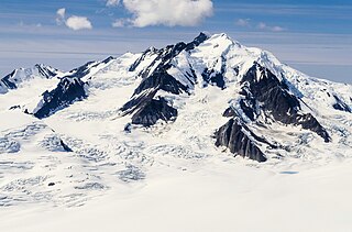
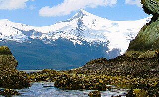
Mount Bertha is a 10,204-foot (3,110-meter) glaciated mountain summit located in the Fairweather Range of the Saint Elias Mountains, in southeast Alaska, United States.

Black Cap Mountain is a 3,321-foot (1,012-meter) mountain summit located in Glacier Bay National Park and Preserve, in the Alsek Ranges of the Saint Elias Mountains, in southeast Alaska. The mountain is situated immediately north of the entrance to Tidal Inlet, 80 mi (129 km) northwest of Juneau, and 3.5 mi (6 km) south of Mount Merriam, which is the nearest higher peak. Although modest in elevation, relief is significant as the mountain rises up from tidewater in less than two miles. The mountain's descriptive name was given by the U.S. Geological Survey in 1956 because the summit is composed of black limestone which contrasts with the color of the flanks of the mountain, making it visible for many miles. The mountain's name was officially adopted in 1960 by the U.S. Board on Geographic Names. Weather permitting, Black Cap Mountain can be seen from Glacier Bay, which is a popular destination for cruise ships. The months May through June offer the most favorable weather for viewing or climbing the peak.
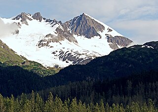
Phoenix Peak is a 5,187-foot (1,581 m) mountain summit located in the Kenai Mountains, on the Kenai Peninsula, in the U.S. state of Alaska. The peak is situated in Kenai Fjords National Park, 2 mi (3 km) southwest of Mount Benson, 1.1 mi (2 km) northwest of Marathon Mountain, and 3.5 mi (6 km) west of Seward, Alaska. Precipitation runoff from the mountain and meltwater from its glaciers drains into tributaries of the Resurrection River. The first ascent of the peak was made July 23, 1964, by Don Stockard of the Mountaineering Club of Alaska. The peak was named in 1965 by the Mountaineering Club of Alaska for the first ship ever built in Russian America, the Phoenix, which was constructed in 1794 by Russians in nearby Resurrection Bay. The mountain's toponym was officially adopted in 1966 by the United States Geological Survey.

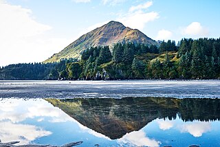
Cecil Rhode Mountain is a 4,400-foot (1,341 m) mountain summit located in the Kenai Mountains, on the Kenai Peninsula in the state of Alaska. The mountain is situated in Chugach National Forest, 50 mi (80 km) south of Anchorage, and 1.7 mi (3 km) south of Cooper Landing, Alaska. This peak is shown on maps as Cooper Benchmark, the northernmost peak on a ridge which includes Stetson Benchmark, and Peak 4593.

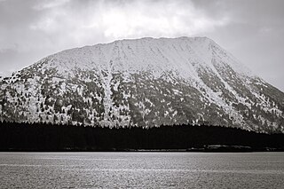
Mount Robert Barron is a 3,475-foot (1,059 m) elevation mountain summit located on Admiralty Island in the Alexander Archipelago, in the U.S. state of Alaska. It is the highest point on the island's Mansfield Peninsula, and is situated 16 mi (26 km) west-southwest of Juneau, on land managed by Tongass National Forest. Although modest in elevation, relief is significant since the peak rises up from tidewater at Funter Bay on Lynn Canal in less than two miles, and from Stephens Passage to the east in less than three miles.

Mount Raymond is a 10,241-foot elevation (3,121 m) mountain summit located in Salt Lake County, Utah, United States.
Mount Leeper is a 9,603-foot-elevation (2,927-meter) mountain summit in Alaska, United States.
Icy Peak is a 4,550-foot-elevation (1,390-meter) mountain summit in Alaska, United States.

Porter Peak is a 4,839-foot (1,475 m) mountain summit in Alaska.

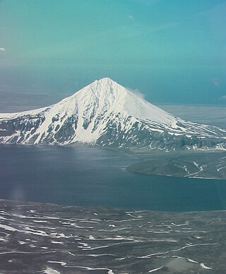
Mount Becharof is a 3,146-foot-elevation (959-meter) mountain summit in Alaska.

Cope Mountain is a 2,496-foot-elevation (761-meter) summit in Alaska.
Devils Prongs is a 2,175-foot-elevation (663-meter) mountain in Alaska.
Kupreanof Mountain is a 2,440-foot-elevation (744-meter) summit in Alaska.
Eickelberg Peak is a 3,648-foot-elevation (1,112-meter) summit in Alaska, United States.

West Saint Peak is a 3,337-foot-elevation (1,017-meter) summit in Alaska.

Mount Emmerich is a 6,877-foot-elevation (2,096-meter) mountain summit in Alaska.
Mount Sumdum is a 6,666-foot-elevation (2,032-meter) mountain summit in Alaska, United States.

Ptarmigan Peak is a 2,972-foot-elevation (906-meter) mountain summit in Alaska, United States.


