| Mount Sumbing | |
|---|---|
| Highest point | |
| Elevation | 2,507 m (8,225 ft) [1] |
| Coordinates | 2°24′50″S101°43′41″E / 2.414°S 101.728°E |
| Geography | |
| Location | Sumatra, Indonesia |
| Geology | |
| Mountain type | Stratovolcano |
| Last eruption | May to June 1921 |
Mount Sumbing is a stratovolcano in the central region of Sumatra, Indonesia. The volcano has a complicated summit region with several craters and a 180 m long crater lake.
Only two known historical eruptions have taken place, one in 1909 and another in 1921. Hot springs occurred in the south-west foot of the volcano. [1]

The Ring of Fire is a region around much of the rim of the Pacific Ocean where many volcanic eruptions and earthquakes occur. The Ring of Fire is a horseshoe-shaped belt about 40,000 km (25,000 mi) long and up to about 500 km (310 mi) wide.

The Indonesian island of Java is almost entirely of volcanic origin, and contains numerous volcanoes, 45 of which are considered active volcanoes. As is the case for many other Indonesian islands, volcanoes have played a vital role in the geological and human history of Java. Indeed, land is created on Java as a result of lava flows, ash deposits, and mud flows (lahars). Volcanoes are a major contributor to the immense fertility of Java, as natural erosion transports volcanic material as alluvium to the island's plains, forming thick layers of fertile sediment. The benefit is not just in the immediate vicinity of the volcano, with fine ash emitted from eruptions being dispersed over wide areas.

Mount Bromo is an active somma volcano and part of the Tengger mountains, in East Java, Indonesia. At 2,329 meters it is not the highest peak of the massif, but the most famous. The area is one of the most visited tourist destinations in East Java, and the volcano is included in the Bromo Tengger Semeru National Park. The name Bromo comes from the Javanese pronunciation of Brahma, the Hindu god of creation. Mount Bromo is located in the middle of a plain called "Sea of Sand", a nature reserve that has been protected since 1919.

Tangkuban Parahu is a stratovolcano 30 km north of the city of Bandung, the provincial capital of West Java, Indonesia. It erupted in 1826, 1829, 1842, 1846, 1896, 1910, 1926, 1929, 1952, 1957, 1961, 1965, 1967, 1969, 1983, 2013 and 2019. It is a popular tourist attraction where tourists hike or ride to the edge of the crater to view the hot water springs and boiling mud up close, and buy eggs cooked on the hot surface. Together with Mount Burangrang and Bukit Tunggul, it is a remnant of the ancient Mount Sunda after the plinian eruption caused the Caldera to collapse.

Mount Agung is an active volcano in Bali, Indonesia, southeast of Mount Batur volcano, also in Bali. It is the highest point on Bali, and dominates the surrounding area, influencing the climate, especially rainfall patterns. From a distance, the mountain appears to be perfectly conical. From the peak of the mountain, it is possible to see the peak of Mount Rinjani on the nearby island of Lombok, to the east, although both mountains are frequently covered in clouds. Agung is a stratovolcano, with a large and deep crater. Its most recent eruptions occurred from 2017–2019.
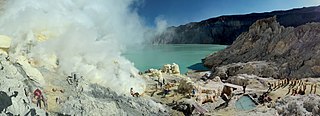
The Ijen volcano complex is a group of composite volcanoes located on the border between Banyuwangi Regency and Bondowoso Regency of East Java, Indonesia. It is known for its blue fire, acidic crater lake, and labour-intensive sulfur mining.
Kaba, a twin volcano with Mount Hitam in Bengkulu Province of Indonesia, has an elongated summit crater complex dominated by three large historically active craters trending ENE from the summit to the upper NE flank. The SW-most crater of Gunung Kaba, Kawah Lama, is the largest. Most historical eruptions have affected only the summit region of the volcano. They mostly originated from the central summit craters, although the upper-NE flank crater Kawah Vogelsang also produced explosions during the 19th and 20th centuries. In 1833 an eruption ejected water from the crater lake, forming lahars that produced damage and fatalities at Talang, Klingi, and Bliti villages.

Kelud is an active stratovolcano located in Kediri, East Java, Indonesia. Like many Indonesian volcanoes and others on the Pacific Ring of Fire, Kelud is known for large explosive eruptions throughout its history. More than 30 eruptions have occurred since 1000 AD. In 2007, an effusive explosion filled the crater with a lava dome. It last erupted on February 13, 2014, destroying the lava dome and ejecting boulders, stones and ashes up to West Java about 500 kilometers from Mount Kelud. The crater filled with water during the rainy season.

A volcanogenic lake is a lake formed as a result of volcanic activity. They are generally a body of water inside an inactive volcanic crater but can also be large volumes of molten lava within an active volcanic crater and waterbodies constrained by lava flows, pyroclastic flows or lahars in valley systems. The term volcanic lake is also used to describe volcanogenic lakes, although it is more commonly assigned to those inside volcanic craters.

Kelimutu is a volcano, close to the small town of Moni in central Flores island in Indonesia. It is around 50 km (31 mi) to the east of Ende, Indonesia, the capital of Ende regency in East Nusa Tenggara province. It has three volcanic crater lakes that differ in color.

Mount Sumbing or Gunung Sumbing is an active stratovolcano in Central Java, Indonesia that is symmetrical like its neighbour, Mount Sindoro. The only report of historical eruptions is from 1730. It has created a small phreatic crater at the summit.

Mount Papandayan is a complex stratovolcano, located in Garut Regency, to the southeast of the city of Bandung in West Java, Indonesia. It is about 15 km to the southwest of the town of Garut. At the summit, there are four large craters which contain active fumarole fields. An eruption in 1772 caused the northeast flank to collapse producing a catastrophic debris avalanche that destroyed 40 villages and killed nearly 3,000 people. The eruption truncated the volcano into a broad shape with two peaks and a flat area 1.1 km wide with Alun-Alun crater in the middle, making the mountain appear as a twin volcano; one of the peaks is called Papandayan and the other Mount Puntang.

Kamojang, popularly known as Kawah Kamojang or, is a geothermal field and tourist spot in West Java, Indonesia. The crater is located in sub-district (kecamatan) Ibun in the Bandung Regency, approximately 45 km to the southeast of Bandung through the towns of Majalaya and Ibun. The crater can also be reached from the opposite direction through the town of Garut, in Garut Regency.

Dieng Volcanic Complex is on the Dieng Plateau in the Central Java, Indonesia, a complex of volcanoes. The volcanic complex consists of two or more of stratovolcanoes, more than 20 small craters and Pleistocene-to-Holocene age volcanic cones. It covers over 6 × 14 km area. The Prahu stratovolcano was truncated by a large Pleistocene caldera and then filled by parasitic cones, lava domes and craters which is 120 Celsius. Some of them are turned into lakes. Toxic volcanic gas has caused fatalities and is a hazard at several craters. On 20 February 1979 149 people died of gas poisoning in Pekisaran village on the plateau near the Sinila crater. The area is also home to a major geothermal project.
Mount Patah is the highest mountain in the Indonesian province of Bengkulu, it is a heavily forested quaternary age volcano southeast of Mount Dempo on Sumatra island, Indonesia. On 1 May 1989, a fumarole activity was observed by a pilot near the summit. The exact location of the crater, the date of its formation and its geologic relationship is uncertain.

Temanggung Regency is a regency in the Central Java Province of Indonesia. It covers a land area of 870.65 km2 and had a population of 708,546 at the 2010 Census and 790,174 at the 2020 Census. Its capital is the town of Temanggung.

Borobudur Temple Compounds is the World Heritage designation of the area of three Buddhist temples in Central Java, Indonesia. It comprises Borobudur, Mendut, and Pawon. The temples were built during the Shailendra dynasty around the 8th and 9th centuries CE, and fall on a straight line.
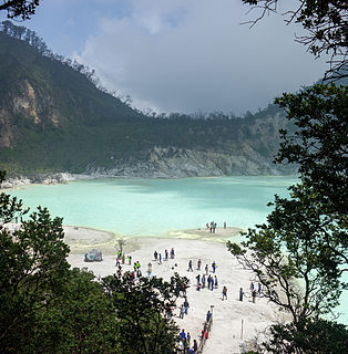
Kawah Putih is a crater lake and tourist spot in a volcanic crater about 50 kilometres (31 mi) south of Bandung in West Java in Indonesia.

Moung Andong is a shield type mountain in Magelang Regency, Central Java in Indonesia. This mountain has never had an erupting activity. Andong mountain is located between Ngablak and Tlogorjo, Grabag and has an altitude of around 1,463 meters. Andong Mountain is one of several mountains that encircle Magelang, adjacent to Mount Telomoyo. The mountain is on the border of the Salatiga, Semarang and Magelang regions.
| | This Jambi location article is a stub. You can help Wikipedia by expanding it. |