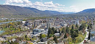
Kamloops is a city in south-central British Columbia, Canada, at the confluence of the North and South Thompson Rivers, which join to become the Thompson River in Kamloops, and east of Kamloops Lake. It is located in the Thompson-Nicola Regional District, whose district offices are based here. The surrounding region is sometimes referred to as the Thompson Country.

Mount Garibaldi is a dormant stratovolcano in the Garibaldi Ranges of the Pacific Ranges in southwestern British Columbia, Canada. It has a maximum elevation of 2,678 metres and rises above the surrounding landscape on the east side of the Cheakamus River in New Westminster Land District. In addition to the main peak, Mount Garibaldi has two named sub-peaks. Atwell Peak is a sharp, conical peak slightly higher than the more rounded peak of Dalton Dome. Both were volcanically active at different times throughout Mount Garibaldi's eruptive history. The northern and eastern flanks of Mount Garibaldi are obscured by the Garibaldi Névé, a large snowfield containing several radiating glaciers. Flowing from the steep western face of Mount Garibaldi is the Cheekye River, a tributary of the Cheakamus River. Opal Cone on the southeastern flank is a small volcanic cone from which a lengthy lava flow descends. The western face is a landslide feature that formed in a series of collapses between 12,800 and 11,500 years ago. These collapses resulted in the formation of a large debris flow deposit that fans out into the Squamish Valley.

The following is an alphabetical list of articles related to the Canadian province of British Columbia.

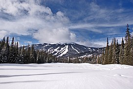
Sun Peaks Resort is an alpine ski resort located in Sun Peaks, British Columbia, Canada, 56 km (35 mi) northeast of Kamloops.

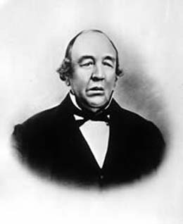
John Work was a Chief Factor of the Hudson's Bay Company and head of one of the original founding families in Victoria, British Columbia. Work joined the Hudson's Bay Company in 1814 and served in many capacities until his death in 1861, ultimately becoming a member of the company's Board of Management for its Western Department. He also served on Vancouver Island's Legislative Council. At the time of his death, Work was the largest private land owner of Vancouver Island. Work left an important legacy in the form of sixteen journals which chronicle his trading expeditions from 1823 to 1851. His journals provide a detailed record of Pacific Northwest land features, native peoples, and the Hudson's Bay Company's fur trading business in the early 19th century.
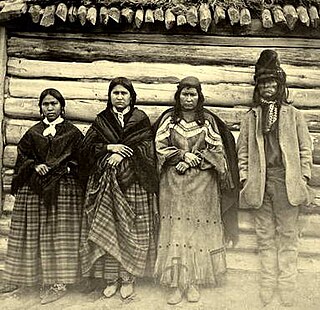
Tkʼemlúps te Secwépemc, abbreviated TteS and previously known as the Kamloops Indian Band, is a First Nations government within the Shuswap Nation Tribal Council, which represents ten of the seventeen Secwepemc band governments, all in the southern Central Interior region, spanning the Thompson and Shuswap districts. It is one of the largest of the 17 groups into which the Secwepemc (Shuswap) nation was divided when the Colony of British Columbia established an Indian reserve system in the 1860s.

Chase is a village located in the Interior of British Columbia, Canada. It has a population of 2,399, and its main industries are forestry and tourism. It is located at the outlet of Little Shuswap Lake, which is the source of the South Thompson River. Chase Creek, which drops over three small waterfalls before flowing through the town, enters the South Thompson just below the lake's outlet.

The North Shore Mountains are a mountain range overlooking Vancouver in British Columbia, Canada. Their southernmost peaks are visible from most areas in Vancouver and form a distinctive backdrop for the city.
The Bonaparte Plateau, in British Columbia, Canada, is a sub-plateau of the Thompson Plateau which extends to the Quesnel River and lies between the Cariboo Mountains on the east and the Fraser River on the west. The Thompson Plateau is itself a sub-plateau of the larger Fraser Plateau.

Paul Lake Provincial Park is a provincial park in British Columbia, Canada, located southwest of Heffley Lake and to the northeast of the city of Kamloops.
Nicola, also Nkwala or N'kwala, was an important First Nations political figure in the fur trade era of the British Columbia Interior as well as into the colonial period (1858–1871). He was grand chief of the Okanagan people and chief of the Nicola Valley peoples, an alliance of Nlaka'pamux and Okanagans and the surviving Nicola Athapaskans, and also of the Kamloops Band of the Shuswap people.

Canim Lake is a lake in British Columbia, Canada. Its west end is 36 km (22.4 mi) northeast of 100 Mile House. "Canim" means a type of large canoe in the Chinook Jargon. Canim Lake is 26.5 km (16.5 mi) long. It is also part of the territory of the Shuswap First Nation where the ancestors are part of the Lake Division of the Shuswap nation of the Interior Nations of British Columbia. The Reilly Commission states that the 2,029 hectares region around Canim Lake are set aside for the Shuswap First Nation. In the summer of 1995, there was an archaeological evidence of an ancient civilization and evidence of carbon dated as 4,300 old.
The Fitzsimmons Range is a small mountain range on the northwestern edge of the Garibaldi Ranges in southwestern British Columbia, Canada, located between the valleys of Cheakamus Lake (SW) and Fitzsimmons Creek (NE). Its most famous summit is Whistler Mountain, which overlooks the resort town of Whistler and is one of the two mountains forming the Whistler Blackcomb ski resort. Most of the range is within Garibaldi Provincial Park, while its northeastern extremity is part of the resort municipality, and of the lands associated with the ski resort operation. Other summits in the range include Oboe Summit, Piccolo Summit and Flute Summit, which are hillocks along the ridge running southeast from Whistler Mountain and were named in association with the renaming of Whistler. Beyond them is Singing Pass and Mount Fitzsimmons 2603 m (8540 ft) which is at the opposite end of the range from Whistler Mountain and the location of Fitzsimmons Glacier, which is the source of Fitzsimmons Creek.
The Simpcw First Nation, formerly known as the North Thompson Indian Band, is a First Nations band government based in the Thompson Country of British Columbia, Canada. It is a member of the Shuswap Nation Tribal Council. It is a First Nations government of the Secwepemc (Shuswap) Nation, located in the Central Interior region of the Canadian province of British Columbia. The band's main community is at Chu Chua, British Columbia. Four of the five First Nation Reserves in Simpcw territory were designated on July 5, 1877 and the fifth was designated on February 24, 1916. The Shuswap language name for North Thompson Band's community and reserve is 'Simpcw'.

Jean Baptiste Lolo also known as St. Paul or Chief St. Paul, or Chief Lolo, was an employee and interpreter with the Hudson's Bay Company in pre-Confederation British Columbia, Canada. Son of Chief Michael Okanese 'Little Bone' Cardinal. First serving in the region at Fort Fraser in the New Caledonia fur district, he acquired the nickname there of St. Paul because of his affection for that saint. He was the right-hand man of John Tod and followed him to Fort Kamloops, where Tod was Chief Trader from 1841 to 1843, and remained in that region for the rest of his life. He acquired such great respect among the local Secwepemc (Shuswap) people as to become regarded as a chief.
"His face was a very fine one, although sickness and pain had worn it away terribly. His eyes were black, piercing and restless; his cheekbones high, and the lips, naturally thin and close, had that white, compressed look which tells so surely of constant suffering."
When Mayne remarked that Lolo, in his decayed health, must find it hard to rule over his people,
"... he heard me with a grim smile, and for answer turned back his pillow, where a loaded gun and a naked sword lay ready to his hand."
The invalid Lolo showed, in fact, unexpected reserves of strength. Rising from his bed, he mounted his horse, and accompanied Mayne on a ride to see the view from the top of a neighbouring mountain, which was forthwith named Mt. St. Paul in honour of the old chief. Moreover, Lolo insisted on accompanying Mayne on the next lap of his journey, that from Kamloops to Pavilion."
Mount Lolo, 1748m (5735'), prominence 818m, is a summit 20 km northeast of Kamloops, British Columbia, Canada, between Paul and Heffley Lakes. The summit is part of a small portion of the Interior Plateau which lies within the angle of the confluence of the South and North Thompson Rivers, to the east of which is an upland area known as the Shuswap Highland.
Mount Lolo, 218m is a summit in Sayward Land District on the west side of Quadra Island, British Columbia, Canada, overlooking Seymour Narrows.

Dunn Peak is a group of peaks in the central Interior of British Columbia, Canada. Its most prominent summit, Matterhorn Peak, rises to 2,636 metres (8,648 ft), making it the highest point in the Shuswap Highland. The peak and its surroundings are contained in Dunn Peak Provincial Park.
Barrière River is a tributary of the North Thompson River, one of the main tributaries of the Fraser River, in the Canadian province of British Columbia. It flows through the Shuswap Highland region north of Kamloops. Its name in Secwepemctsín is St́yelltsecwétkwe.


