Mulwaree Parish

Last updated
Mulwaree is center of picture. Lake george nsw.jpg
Mulwaree is center of picture.

The Parish of Mulwaree is a parish of Argyle County [1] and former village and local government area. It is located on the western shore of Lake Bathurst, New South Wales. [2] [3]

Argyle County Cadastral in New South Wales, Australia

Argyle County was one of the original Nineteen Counties in New South Wales and is now one of the 141 Cadastral divisions of New South Wales. It includes the area around Goulburn. It is bounded by Lake George in the south-west, the Shoalhaven River in the east, and the Wollondilly River in the north-east.

Village Small clustered human settlement smaller than a town

A village is a clustered human settlement or community, larger than a hamlet but smaller than a town, with a population ranging from a few hundred to a few thousand. Though villages are often located in rural areas, the term urban village is also applied to certain urban neighborhoods. Villages are normally permanent, with fixed dwellings; however, transient villages can occur. Further, the dwellings of a village are fairly close to one another, not scattered broadly over the landscape, as a dispersed settlement.

West one of the four cardinal directions

West is one of the four cardinal directions or points of the compass. It is the opposite direction from east.

Contents

History

The area was traditional lands of the Ngunnawal people, but was also traversed by other tribes going to the coast or the Monaro during the Bogong moth season. Stone artefacts dating back 20,000 years have been found at nearby Lake George.

Ngunnawal indigenous Australian group

The Ngunawal are an indigenous Australian people of southern New South Wales.

Monaro (New South Wales) Region in New South Wales, Australia

Monaro, once frequently spelled "Manaro", or in early years of settlement "Maneroo" is a region in the south of New South Wales, Australia. A small area of Victoria near Snowy River National Park is geographically part of the Monaro. While the Australian Capital Territory is not considered part of the region, some towns in the Monaro have close links with Canberra.

Bogong moth species of insect

The bogong moth is a temperate species of night-flying moth, notable for its biannual long-distance seasonal migrations towards and from the Australian Alps, similar to the diurnal monarch butterfly. During the autumn and winter it is found in southern Queensland, western New South Wales, western Victoria, and also in South and Western Australia. Adult bogong moths breed and larvae hatch during this period, consuming winter pasture plants during their growth. During the spring, the moths migrate south or east and reside in mountains such as Mount Bogong, where they gregariously aestivate over the summer until their return towards breeding grounds again in the autumn.

The Lake Bathurst was discovered in April 1818 by an exploration commissioned by Governor Lachlan Macquarie to find a route from the inland to the settlement on the south coast at Jervis Bay that was headed by Surveyor General James Meehan. A village of Mulwaree was gazetted in the 19th century on the southern shore of Lake Bathurst, but failed to grow, moving 1½km to the west at the site of Tarago, on the main trainline.

Lachlan Macquarie Scottish British army officer and New South Wales colonial administrator

Major General Lachlan Macquarie, CB was a British Army officer and colonial administrator from Scotland. Macquarie served as the fifth and last autocratic Governor of New South Wales from 1810 to 1821, and had a leading role in the social, economic and architectural development of the colony. He is considered by historians to have had a crucial influence on the transition of New South Wales from a penal colony to a free settlement and therefore to have played a major role in the shaping of Australian society in the early nineteenth century. In 1816 Macquarie gave orders that led to the Appin Massacre of Gundungurra and Dharawal people.

Jervis Bay bay in New South Wales, Australia

Jervis Bay is a 102-square-kilometre (39 sq mi) oceanic bay and village on the south coast of New South Wales, Australia, said to possess the whitest sand in the world.

The Surveyor General is an official responsible for government surveying in a specific country or territory. Historically this would often have been a military appointment, but it is now more likely to be a civilian post.

Geography

Significant features in the parish include:

The Mulwaree River, a perennial river that is part of the Hawkesbury-Nepean catchment, is located in the Southern Tablelands region of New South Wales, Australia.

A perennial stream or perennial river is a stream or river (channel) that has continuous flow in parts of its stream bed all year round during years of normal rainfall. "Perennial" streams are contrasted with "intermittent" streams which normally cease flowing for weeks or months each year, and with "ephemeral" channels that flow only for hours or days following rainfall. During unusually dry years, a normally perennial stream may cease flowing, becoming intermittent for days, weeks, or months depending on severity of the drought. The boundaries between perennial, intermittent, and ephemeral channels are not defined, and subject to a variety of identification methods adopted by local governments, academics, and others with a need to classify stream-flow permanence.

Hawkesbury River river in New South Wales, Australia

The Hawkesbury River, is a semi–mature tide dominated drowned valley estuary located to the west and north of Sydney, New South Wales, Australia. The Hawkesbury River and its associated main tributary, the Nepean River, virtually encircle the metropolitan region of Sydney.

Ecology

The lake is an important site for Australasian shovellers. Anas-rhynchotis-variegata.jpg
The lake is an important site for Australasian shovellers.

The area has been identified by BirdLife International as an Important Bird Area (IBA) because it regularly supports significant numbers of

BirdLife International is a global partnership of conservation organisations that strives to conserve birds, their habitats, and global biodiversity, working with people towards sustainability in the use of natural resources. It is the world's largest partnership of conservation organisations, with over 120 partner organisations.

Important Bird Area area recognized as being globally important habitat for the conservation of birds populations

An Important Bird and Biodiversity Area (IBA) is an area identified using an internationally agreed set of criteria as being globally important for the conservation of bird populations.

Blue-billed duck species of bird

The blue-billed duck is a small Australian stiff-tailed duck, with both the male and female growing to a length of 40 cm (16 in). The male has a slate-blue bill which changes to bright-blue during the breeding season, hence the duck’s common name. The male has deep chestnut plumage during breeding season, reverting to a dark grey. The female retains black plumage with brown tips all year round. The duck is endemic to Australia's temperate regions, inhabiting natural inland wetlands and also artificial wetlands, such as sewage ponds, in large numbers. It can be difficult to observe due to its cryptic nature during its breeding season through autumn and winter. The male duck exhibits a complex mating ritual. The blue-billed duck is omnivorous, with a preference for small aquatic invertebrates. BirdLife International has classified this species as Near Threatened. Major threats include drainage of deep permanent wetlands, or their degradation as a result of introduced fish, peripheral cattle grazing, salinization, and lowering of ground water.

Freckled duck species of bird

The freckled duck is a waterfowl species endemic to Australia. The freckled duck has also been referred to as the monkey duck or the oatmeal duck. These birds are usually present in mainland Australia, but disperse to coastal and subcostal wetlands in the dry period. During such times it is common for the freckled duck population to congregate in flocks in the same area, giving the impression that they are more common than they really are.

Black swan species of bird

The black swan is a large waterbird, a species of swan which breeds mainly in the southeast and southwest regions of Australia. Within Australia they are nomadic, with erratic migration patterns dependent upon climatic conditions. Black swans are large birds with mostly black plumage and red bills. They are monogamous breeders, and are unusual in that one-quarter of all pairings are homosexual, mostly between males. Both partners share incubation and cygnet rearing duties.

See also

Economy

The Parish is predominantly Agricultureal in its economic base, however, the economic base has diversified in recent years with:

The parish has begun to be used as commuter zone for the nearby city of Canberra.

Related Research Articles

King Island (Tasmania) island between Australia and Tasmania

King Island is an island in the Bass Strait, belonging to the Australian state of Tasmania. It is the largest of three islands known as the New Year Group, and the second-largest island in Bass Strait. The island's population at the 2016 census was 1,585 people, up from 1,566 in 2011. The local government area of the island is the King Island Council.

Division of Hume Australian federal electoral division

The Division of Hume is an Australian electoral division in the state of New South Wales. The division was proclaimed in 1900, and was one of the original 65 divisions to be contested at the first federal election. The division was named after Hamilton Hume, one of the first Europeans to travel through the area.

Tarago, New South Wales Town in New South Wales, Australia

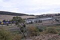
Tarago is a town in the Southern Tablelands of New South Wales, Australia in Goulburn Mulwaree Council. Part of the defined locality, which includes a large area of grazing country, is on the eastern shore of Lake George in the area of the Queanbeyan–Palerang Regional Council. The town is situated 39 kilometres south of the city of Goulburn and 69 kilometres northeast of Canberra, the capital city of Australia. It is located on the Goulburn-Braidwood road. The town is notable for recent renewable energy projects in the surrounding districts.

Bungendore Town in New South Wales, Australia

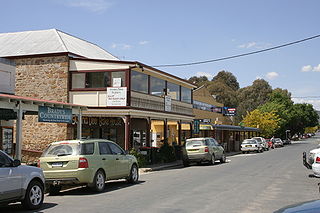
Bungendore is a town in the Queanbeyan Region of New South Wales, Australia, in Queanbeyan-Palerang Regional Council. It is on the Kings Highway near Lake George, the Molonglo River Valley and the Australian Capital Territory border. It has become a major tourist centre in recent years, popular with visitors from Canberra and some of it has heritage protection. It has expanded rapidly in recent years as a dormitory town of Canberra.

Bawley Point New South Wales, Australia

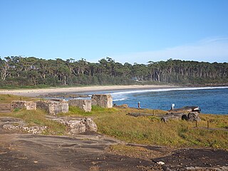
Bawley Point is a small coastal hamlet in New South Wales, Australia, in the Shoalhaven with a population of 698 people at the 2016 census. It is located 30 minutes south of Ulladulla, New South Wales, and 30 minutes north of Batemans Bay on the South Coast of NSW. The town's name is believed to be derived from an Aboriginal word meaning "Brown snake".

Electoral district of Goulburn state electoral district of New South Wales, Australia

Goulburn is an electoral district of the Legislative Assembly in the Australian state of New South Wales. It is represented by Wendy Tuckerman of the Liberal Party.

Thomas Robert "Tom" Frame is an Australian Anglican bishop, historian, academic, author and social commentator.

Lake Bathurst (New South Wales) Town in New South Wales, Australia

Lake Bathurst is a shallow lake located 27 kilometres (17 mi) south-east of Goulburn, New South Wales in Australia. It is also the name of a nearby locality in the Goulburn Mulwaree Council.

Parish of Tarago Cadastral in New South Wales, Australia

The Parish of Tarago is a parish of Argyle County. It does not actually contain the town of Tarago, which is located further to the south-east in the Parish of Mulwaree.

The Capital Wind Farm near Bungendore is the largest wind farm in New South Wales. It is part of the 6,000-hectare (15,000-acre) Capital Renewable Energy Precinct, along with nearby Woodlawn Wind Farm and the Capital East Solar Demonstration Plant.

Menindee Lakes

The Menindee Lakes is a chain of shallow ephemeral freshwater lakes connected to the Darling River to form a storage system. The lakes lie in the far west region of New South Wales, Australia, near the town of Menindee.

Narran Wetlands Protected area in New South Wales, Australia

The Narran Wetlands, also known as the Narran Lakes, contained within the Narran Lakes Nature Reserve, comprise a series of protected ephemeral lakes and swamps fed by the Narran River in the north-west of New South Wales, Australia. The 26,480-hectare (65,400-acre) reserve is located approximately 50 kilometres (31 mi) east of Brewarrina.

The Woodlawn Wind Farm is a wind farm located near Bungendore, New South Wales. It is part of the Capital Renewable Energy Precinct, along with nearby Capital Wind Farm and the Woodlawn Bioreactor.

Goulburn Mulwaree Council Local government area in New South Wales, Australia

Goulburn Mulwaree Council is a local government area located in the Southern Tablelands region of New South Wales, Australia. The area is located adjacent to the Hume Highway and the Southern Highlands railway line. The estimated resident population of the area stood at 29,609 on 2016 census.

Currawang Cadastral in New South Wales, Australia

Currawang is a locality in the Queanbeyan–Palerang Regional Council, on the edges of Upper Lachlan Shire and Goulburn-Mulwaree Council, in New South Wales, Australia. It is located to the north of Lake George. It shares its name with the Currawang Parish of Argyle County, in which it is located. This was formerly known as the parish of Currowang. Both names derive from an Aboriginal word for the spearwood tree.

Tarago railway station railway station in New South Wales, Australia

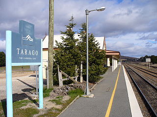
Tarago railway station is a heritate-listed railway station located on the Bombala line in New South Wales, Australia. It serves the town of Tarago. It was built in 1884 by G. & C. Horn. It was added to the New South Wales State Heritage Register on 2 April 1999.

Lower Boro Town in New South Wales, Australia

Lower Boro is a locality in the Goulburn Mulwaree Council area, New South Wales, Australia. It is located about 16 km southeast of Tarago. The link from Tarago to Windellama, which is part of a link from Canberra to Nerriga and Nowra, passes through the northern part of the locality. At the 2016 census, Lower Boro had a population of 176.

Parish of Merigan

Merigan, New South Wales is a civil parish of Murray County, New South Wales.

References

  1. Robert McLean, The New atlas of Australia : the complete work containing over one hundred maps and full descriptive geography of New South Wales, Victoria, Queensland, South Australia and Western Australia, together with numerous illustrations and copious indices (Sydney :J. Sands, [1886) Map 11.
  2. McDonald, J. Kay. (1985). Exploring the ACT and Southeast New South Wales. Kangaroo Press: Sydney.
  3. "European History of Lake Bathurst". argylecounty.com.au.
  4. "Lake Bathurst Birdata". birdata.com.au.