
Coastal Andhra or Kosta Andhra is a geographic region in the Indian state of Andhra Pradesh. Visakhapatnam is the largest city in this region. The region share borders with Rayalaseema region of the state and Telangana. It was a part of Madras State before 1953 and Andhra State from 1953 to 1956. According to the 2011 census, it has an area of 91,915 square kilometres (35,489 sq mi) which is 57.99% of the total state area and a population of 34,193,868 which is 69.20% of Andhra Pradesh state population. This area includes the coastal districts of Andhra Pradesh on the Circar Coast between the Eastern Ghats and the Bay of Bengal, from the northern border with Odisha to Rayalaseema in the south.

Rajahmundry, officially Rajamahendravaram, is a city in the Indian state of Andhra Pradesh and district headquarters of East Godavari district. It is the seventh most populated city in the state. During British rule, the district of Rajahmundry was created in the Madras Presidency in 1823. It was reorganised in 1859 and bifurcated into the Godavari and Krishna districts. Rajahmundry was the headquarters of Godavari district, which was further bifurcated into East Godavari and West Godavari districts in 1925. It is administered under Rajahmundry revenue division of the East Godavari district. The city is known for its floriculture, history, culture, agriculture, economy, tourism, and its heritage. It is known as the "Cultural Capital of Andhra Pradesh".

Bhimavaram is a city and headquarters of West Godavari district of the Andhra Pradesh state of India. It is the administrative headquarters of Bhimavaram mandal in Bhimavaram revenue division. It is a part of Eluru Urban Development Authority. As of 2011 census, it is the most populous urban area in the district with a population of 163,875. It is one of the major pilgrimage centers in the state, which is home to Somaramam, one of the five great Pancharama Kshetras.

Palakollu is a city and the administrative headquarters of Palakollu Mandal in Narasapuram revenue division in West Godavari district of the Indian state of Andhra Pradesh. Palakollu is situated in Coastal Andhra region of the state. It occupies 4.685 square kilometres (1.809 sq mi). As of 2011 census, it had a population of about 61,284 and a Metro population of about 81,199. Palakollu Municipality merged five Grama panchayats of Seven village's on 7 January 2020. The Seven Villages' had a population of 42,932 as of 2011 Census. It around occupies 20.08 square kilometres (7.75 sq mi) and after merged palakollu municipality, It around occupies 24.68 square kilometres (9.53 sq mi) with 35 election wards it is total population of 1,04,216 and making it the third most populous urban area in West Godavari District in Andhra Pradesh. It is a part of Eluru Urban Development Authority.

Tanuku is a Town in West Godavari district of the Indian state of Andhra Pradesh. It is the mandal headquarters of Tanuku mandal. Tanuku is 4th largest town in the West Godavari District after Bhimavaram,Tadepalligudem and Palakollu in terms of population. Tanuku is the Textile Hub of both West Godavari district and East Godavari district. There are a Significant number of Large scale and Small scale Spinning Mills

Tadepalligudem is a city in West Godavari district of the Indian state of Andhra Pradesh. It is a Selection Grade municipality and the mandal headquarters of Tadepalligudem mandal and Tadepalligudem Revenue Division. Tadepalligudem is one of the biggest City in West Godavari district
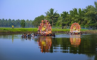
Konaseema is a group of islands between the tributaries of the Godavari River and Bay of Bengal located in Dr. B. R. Ambedkar Konaseema district of Andhra Pradesh in southern India. It is nicknamed "God's own creation" due to similarities with the Kerala backwaters.

Amalapuram is a town in the Indian state of Andhra Pradesh. It is the district headquarters and the third largest town of Dr. B. R. Ambedkar Konaseema district. It is the mandal and divisional headquarters of Amalapuram mandal and Amalapuram revenue division respectively. The town is situated in the delta of konaseema.
Ganti Mohana Chandra Balayogi was an Indian lawyer and politician.
Ramachandrapuram is a town in Dr. B.R. Ambedkar Konaseema district of the Indian state of Andhra Pradesh. The town is a Municipality which serves as the headquarters of Ramachandrapuram mandal and Ramachandrapuram revenue division.

Ravulapalem is a village in Ravulapalem Mandal, Dr. B.R. Ambedkar Konaseema district of Andhra Pradesh. Ravulapalem is the entry point for the lushy green Konaseema Delta region, often called the Kerala of Andhra. Ravulapalem is well known for its Banana Market, diverse cuisine, hospitality of its people & numerous trucking services that caters to PAN India.
Kothapeta is a village in Kothapeta mandal of Dr. B. R. Ambedkar Konaseema of the Indian state of Andhra Pradesh.
Malikipuram is a town of Dr. B.R. Ambedkar Konaseema district in Andhra Pradesh, India. It is located in the Amalapuram revenue division.
Kotipalli railway station, located in the Indian state of Andhra Pradesh, serves Kotipalli in East Godavari district.
Rameswaram is a village in the Kakinada district of Andhra Pradesh, India. The village is situated 5 kilometres west to the district headquarters Kakinada.
Pinipe Viswarup, is an Indian politician from Andhra Pradesh. He worked as a Minister in the cabinets of three chief ministers, YS Rajasekhara Reddy, Rosaiah and Kiran Kumar Reddy. He is an active member of YSR Congress Party and was a supporter of Samaikyandhra movement.
National Highway 216 is a National Highway in the Indian state of Andhra Pradesh. The former highways of NH 214 and 214A were merged and renumbered as NH 216. It starts from NH 16 junction at Kattipudi and passes through Kakinada, Amalapuram, Digamarru (Palakollu), Narasapuram, Machilipatnam, Repalle, Cherukupalle, Bapatla, Chirala before it junctions NH 16 again at Ongole. Visakhapatnam–Kakinada Petro Chemical Corridor, is a proposed project along the highway.

Konaseema district, is one of the 26 districts in the Indian state of Andhra Pradesh. It is situated between the tributaries of the Godavari River in the Konaseema region of Coastal Andhra. It was carved out of East Godavari district on 4 April 2022 by the Government of Andhra Pradesh. Amalapuram is the district headquarters and the largest city in this district. The district shares boundaries with West Godavari, East Godavari and Kakinada districts.
Amalapuram railway station is a railway station currently under construction located in Amalapuram, Dr. B.R. Ambedkar Konaseema district, Andhra Pradesh, India. It will serve as a vital link connecting the cities and villages between Narasapuram and Kakinada once completed and it is owned by Indian Railways.
Ganti Harish Madhur Balayogi commonly known as Ganti Harish Madhur is member of the 18th Lok Sabha. He is the son of Ganti Mohana Chandra Balayogi who served as the speaker of the 12th Lok Sabha when he died in a helicopter crash. His father and mother both served as members of Parliament representing Amalapuram Lok Sabha constituency.

